Record Heat: Longmont Weather Report — March 12 to March 19, 2026
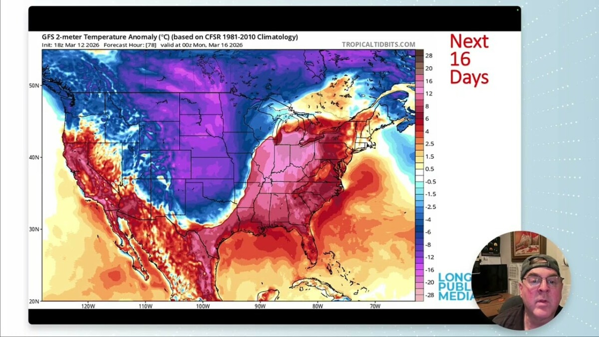
Table of Contents
- Quick summary
- What’s happening now: sun, smoke and daylight
- Drought and the sad state of the snowpack
- Short-term outlook: this weekend through early next week
- The big picture: a massive high pressure ridge and record warm potential
- Humidity and precipitation signals
- Expected precipitation and snow totals (next 5–10 days)
- Daily read on temperatures (forecast highlights)
- Practical takeaways
- FAQ
- Final note
Quick summary
Spring is arriving with a bitter dose of dry and hot. Snowpack remains far below normal, fire danger is elevated, and a massive high pressure ridge off the California coast is setting the stage for a rapid warm-up next week. Expect a brief cool, windy interval Sunday into Monday, then a sharp climb to well above normal temperatures by midweek — possibly into the 80s or 90s in parts of Colorado.
What’s happening now: sun, smoke and daylight
The moon is new and solar activity is quiet. There are a few small sunspots that could nudge geomagnetic activity a little, but nothing major to report. On the daylight front, we’ve gained roughly 19 minutes of sunlight over the last week thanks to the seasonal shift.

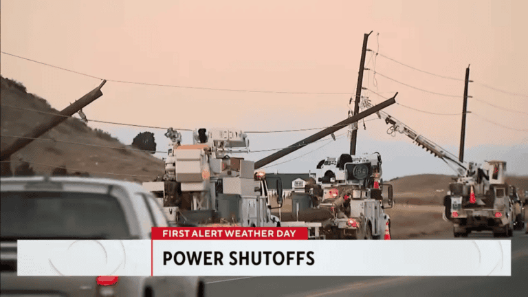
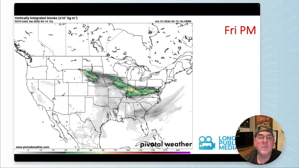
Smoke from fires in Nebraska and Wyoming made an unexpected appearance locally when low-level easterly winds funneled it into Fort Collins and Loveland. Afternoon winds later cleared the layer for much of the Denver–Longmont area, but the episode underscores how far and fast smoke can travel when flow and stability align.
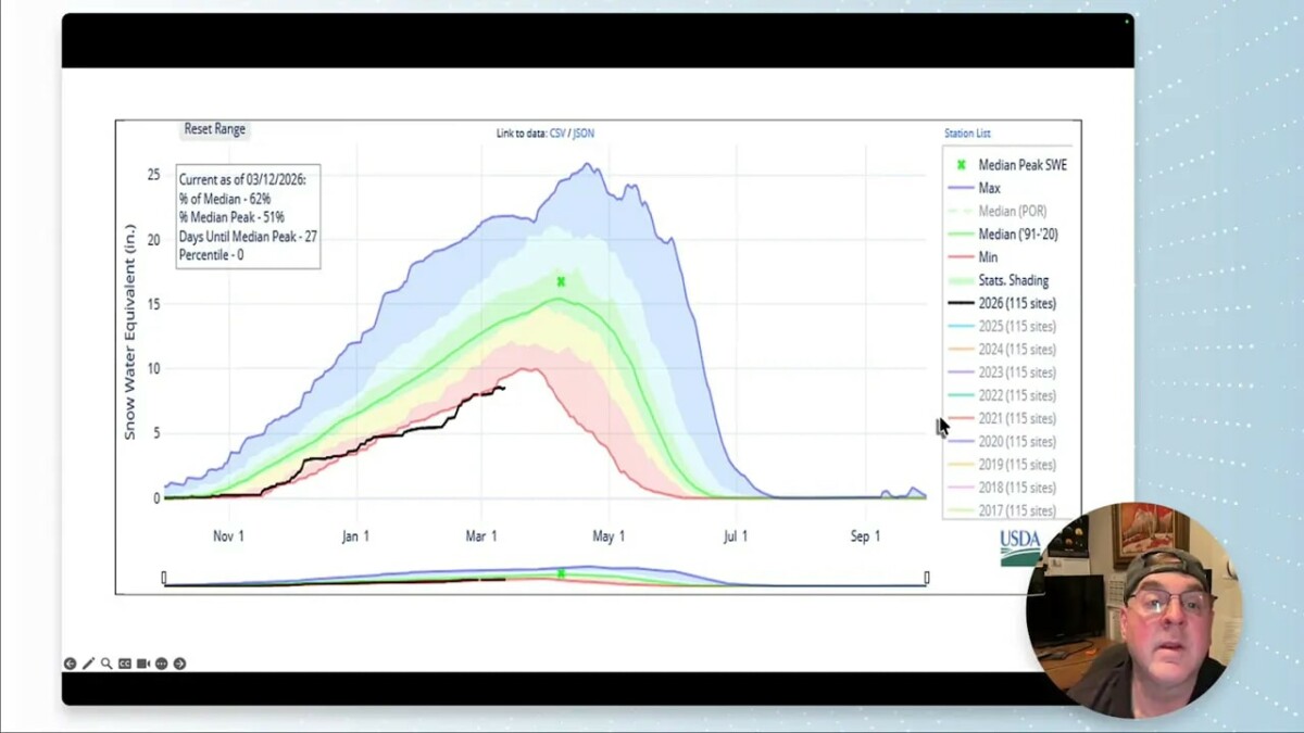
Drought and the sad state of the snowpack
The snowpack is well below normal. Basin-wide numbers sit near 62% of median and only 51% of the median peak. Peak accumulation time is nearly here, which means melting will soon outpace any remaining snowfall. Short-term light precipitation has fallen in a few locations (a few tenths of an inch liquid equivalent), but it is not enough to meaningfully recover the deficit. Overall moisture indicators remain in the red.
Short-term outlook: this weekend through early next week
The next 48 hours are mostly dry. A weak system brushes through late Saturday into Sunday, bringing a windy, cool spell with a rain-snow mix in places Sunday into Monday morning. This cold snap will be brief — roughly 48 hours — before clearing out.
- Friday — Dry; highs climbing into the mid 50s to low 80s depending on timing of the ridge influence.
- Saturday — Chance of late-night showers; highs generally in the 70s for some areas.
- Sunday–Monday — Windy, cooler; rain-snow mix possible in the mountains and foothills; temps dip sharply for ~48 hours.
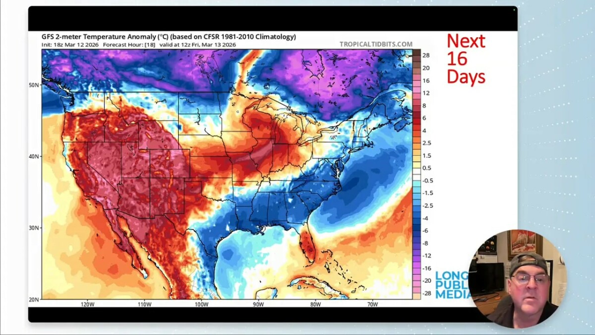
The big picture: a massive high pressure ridge and record warm potential
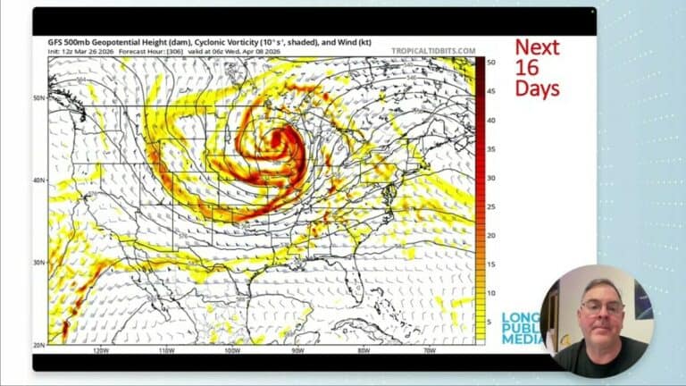
Satellite and model fields show a giant high pressure area off the California coast. This ridge is unusually strong for the season and is forecast to sit and even amplify over the southwest before nudging toward the region next weekend. A persistent ridge like this suppresses cloudiness and precipitation and allows temperatures to soar well above normal.

Temperature anomaly maps indicate regions of Colorado could run 20–30°F above normal during the ridge peak. That raises the realistic possibility of setting March heat records, with some model guidance hinting at highs into the 80s and even 90s by next Thursday or Friday for portions of the state.
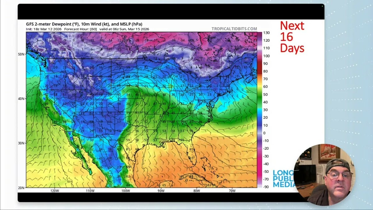
Humidity and precipitation signals
Moisture fields are extremely dry: precipitable water values are low, dew points are often negative, and only a thin ribbon of moisture is expected to sneak through briefly on Sunday. That means any precipitation will be short-lived and limited in area.
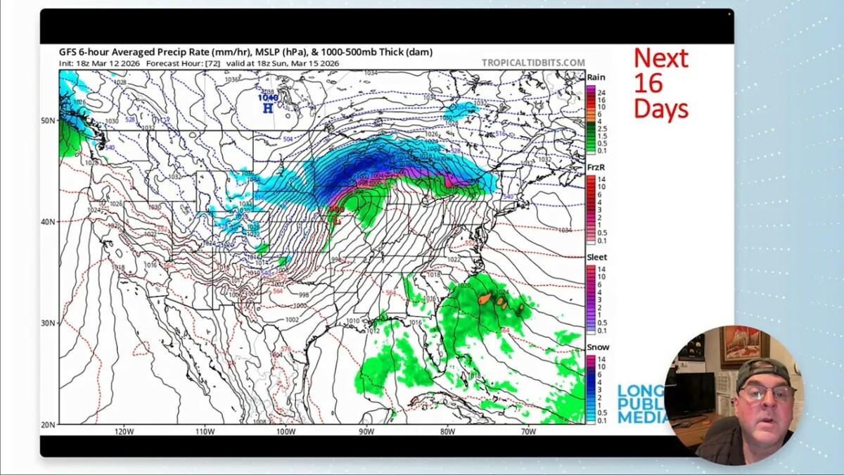
Expected precipitation and snow totals (next 5–10 days)
- Longmont: roughly 0.1 inch liquid over the next five days (very light totals).
- Nearby mountains: small pockets may see over an inch liquid; higher elevations could pick up 8–10 inches of snow in isolated areas.
- Foothills and urban corridor: trace to a few tenths of an inch of snowfall (a tenth to a half inch in spots).
- Overall: the driest pattern dominates once the ridge builds.
Daily read on temperatures (forecast highlights)
The forecast is variable short-term, then climbs rapidly:
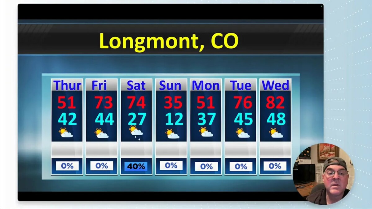
- Thursday: 51°F
- Friday: low to mid 70s in many spots
- Saturday: still in the 70s for some areas
- Sunday: cool down to around 35°F with wind and mixed precipitation
- Monday: rebound to around 51°F
- Tuesday: sharp jump to 76°F
- Wednesday: near 82°F
- Thursday (next week): potential for ~90°F in parts of the region
Practical takeaways
- Be fire-aware. Low humidity and dry fuels plus gusty winds increase the risk of new fires and rapid smoke transport.
- Short, sharp cool period Sunday–Monday. Expect windy conditions and a rain-snow mix in the mountains, then rapid warming.
- Prepare for rapid warming next week. The ridge could produce extreme early-season warmth; watch for heat impacts and stress on water resources.
- Snowpack remains a concern. Below-average snowpack all but guarantees a challenging water year unless significant late-season precipitation arrives.
FAQ
Will we set March temperature records next week?
It is possible. Model guidance shows a strong ridge producing temperatures 20–30°F above normal in parts of Colorado. Some guidance indicates highs could reach the 80s or even 90s next Thursday–Friday. Whether records fall depends on the exact track and strength of the ridge, but the potential for record-breaking warmth is real.
How much precipitation can Longmont expect in the next week?
Very little. Expect roughly 0.1 inch of liquid over the next five days, with perhaps a few tenths of an inch of snow equivalent. The greater threat is continued dryness rather than beneficial precipitation.
Should I be worried about fire danger?
Yes. Low humidity, warm temperatures, and dry fuels elevate fire risk. Even distant fires can cause local smoke problems when winds favor transport, so maintain caution with any outdoor burning and follow local fire advisories.
Will the brief Sunday–Monday storm help the snowpack?
Only marginally. The incoming system is weak and localized; mountain totals may increase in isolated spots, but basin-wide recovery is unlikely from this short event.
Final note
The pattern ahead leans dry and warm, and water resource managers and residents should plan accordingly. Keep an eye on local forecasts for day-to-day changes, especially if you have outdoor plans or concerns about smoke or fire danger. Keep looking up.