Longmont Weather Report: March 26, 2026 to April 2, 2026 and What Comes Next
Here is the week ahead for Longmont and the surrounding Front Range, starting Thursday, March 26, 2026. It is a mix of early warmth, drought pressure, smoke concerns, and a key question hanging over the forecast: will the mountains finally get the moisture the Plains have been missing?
Video
Quick memory hook: a full moon on April 1st. It is one of those dates that makes the whole period easier to keep straight.
Table of Contents
- Sunrise, sunset, and the “big picture” pattern
- Drought is worsening, and the snowpack numbers are the headline
- Smoke and reduced visibility: what to expect
- Temperatures: a cold front Tuesday-Thursday contrast, then warming
- Severe weather season is approaching (and heat plus moisture is the key)
- Precipitation chances: spotty at first, more promising for the mountains
- Long-range watch: a potential stronger storm later in the period
- Snowfall potential: minimal at day 5, more interesting by day 10
- Warming back toward normal, but do not ignore the heat dome
- Week-at-a-glance: Longmont essentials
- FAQ
- Final takeaway
Sunrise, sunset, and the “big picture” pattern
As the calendar turns, the daylight is clearly ramping up. Sunrise is now around 6:50 a.m., and sunset is about 7:45 p.m. This is roughly 19 minutes more light than a week ago.
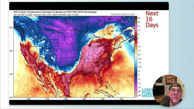
Behind the scenes, the overall pattern is dominated by a strong ridge. That ridge has been helping keep conditions warmer than they should be, and it is also contributing to the bigger-scale dryness across much of the country.
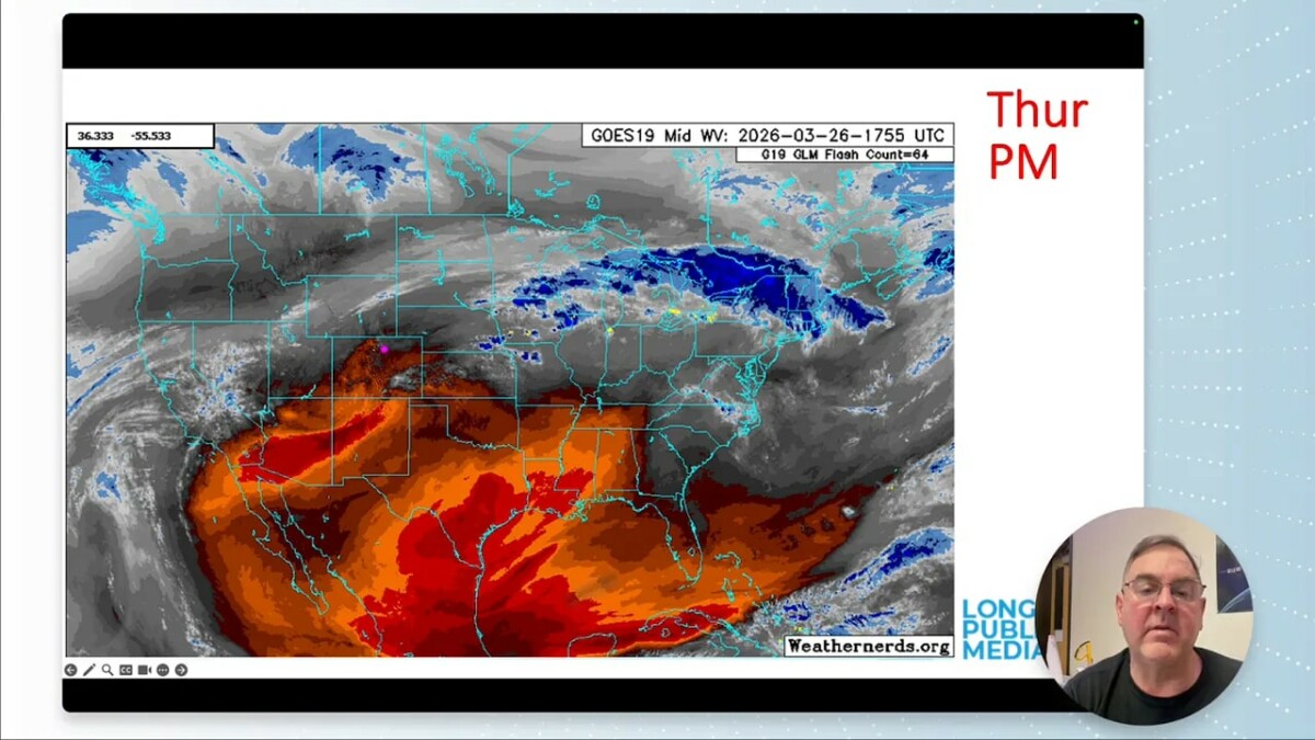
On the water vapor view, you can see super-dry air and the ridge centered over the southern Plains region, with occasional disturbances trying to push moisture in.
Drought is worsening, and the snowpack numbers are the headline
If there is one “real bad news” item in this forecast, it is the snowpack. The snowpack water equivalent is around 34% of median.
And the problem is not just where it stands now. The pattern has offered no meaningful new precipitation while temperatures have been high enough to keep stress on the system. When temperatures climb into the upper 80s and even near 90 degrees on the Plains, that is especially tough on what is left in the snowpack.
Local conditions can still feel “okay” on the Plains compared to what is happening regionally, but drought impacts are expanding nationally, from the West toward Texas and down into parts of Florida.
Smoke and reduced visibility: what to expect
There are local fires and smoke in the region. By Friday, smoke might not directly move into Longmont every time, but it is not far away.
The key operational detail: smoke can shift with the wind. That means some days could bring smoky smells or periods of reduced visibility, even if the heavy smoke plume does not “arrive” like a movie scene.
Temperatures: a cold front Tuesday-Thursday contrast, then warming
In the short term, Thursday starts warm, then a cold front brings a drop into the 50s. But the temperature trend does not stay cool.
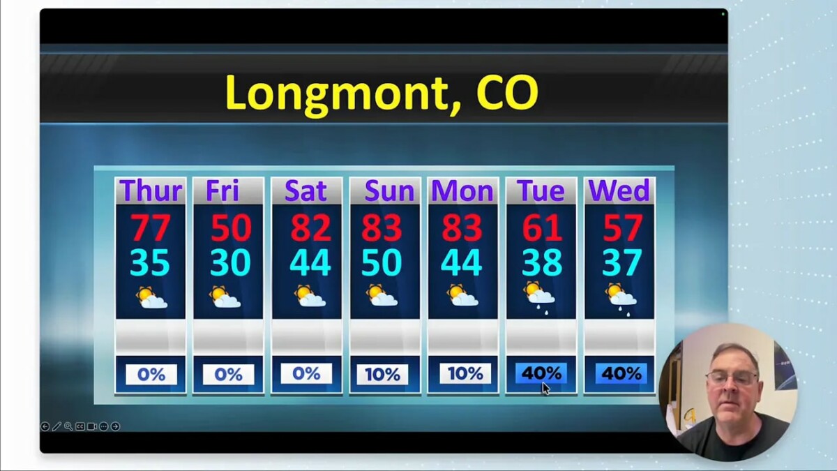
- Thursday: near 77 degrees, then cooling as a front moves through.
- Friday through the weekend: rapid warm-up, with highs climbing back into the 80s.
- Longer look: conditions settle closer to normal after early-month precipitation, but normals themselves are rising as the season advances.
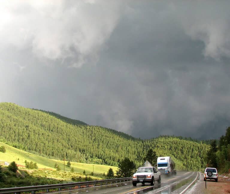
Severe weather season is approaching (and heat plus moisture is the key)
By the last week of March, the severe weather setup becomes a real consideration. The forecast notes severe weather climatology is entering the region with an elevated chance of severe weather, even if it is not quite “touching Colorado” in a direct way.
The meteorological logic is straightforward: heat is already in place, and if the system can bring moisture plus a good trough, thunderstorms can become more impactful sooner than many people expect in late March.
Thunderstorm timing
- Thursday: a chance of convection tied to a front drifting through.
- Friday: more general thunderstorms as the front sags south.
- Saturday: the front is farther south, with thunderstorm potential more focused toward southern areas.
Precipitation chances: spotty at first, more promising for the mountains
Over the next several days, precipitation looks spotty. Plains precipitation is not expected to be widespread, but the mountains are where the forecast starts to look more encouraging.
There are also measurable signals in the models, including a very small amount of measurable water around Wednesday (on the order of 0.2 to 0.25 inch).
What changes near April 1
The period around March 31 and April 1 is important. That is when the forecast suggests:
- Western slope rains, then
- eventual rains in the northeast Plains.
Into April 2, another low may offer a bit of a push, including some mountain rain and at most spotty Plains coverage.
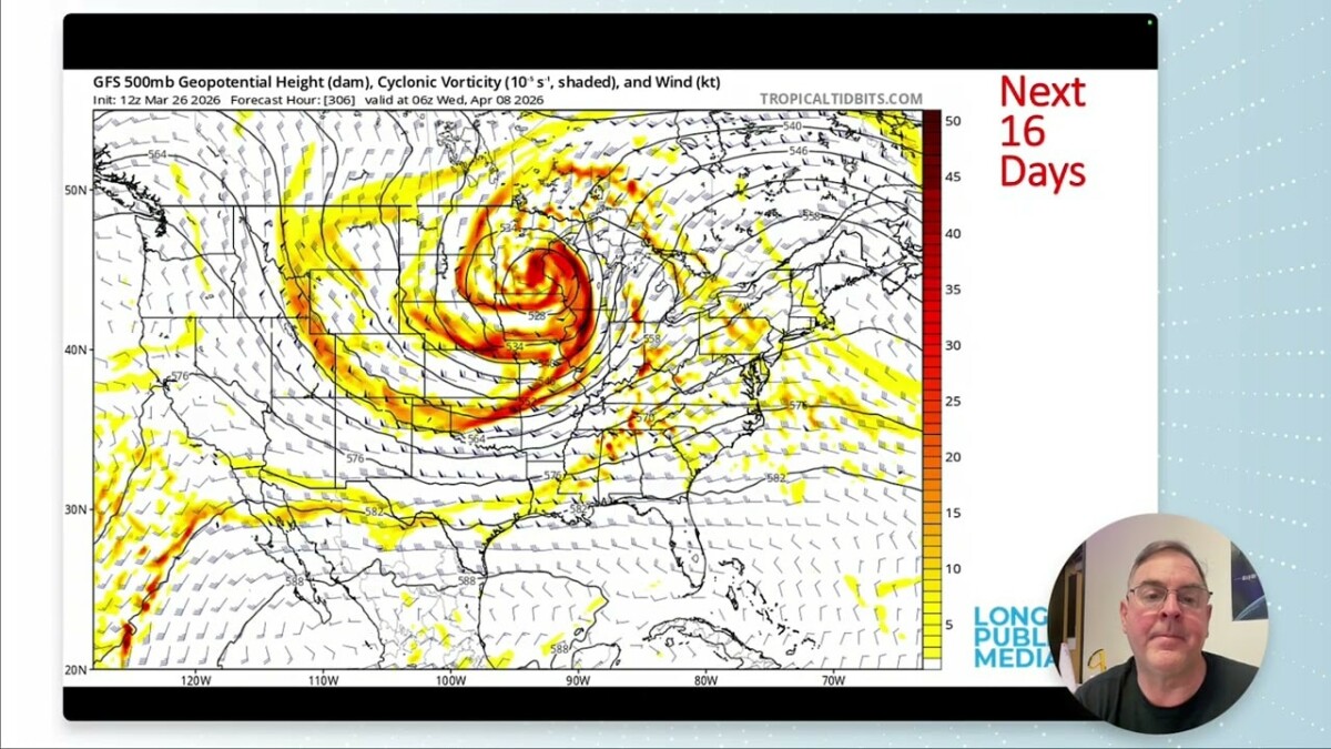
Long-range watch: a potential stronger storm later in the period
There are recurring trough patterns in the forecast timing. The overall story is that ridges keep returning, but troughs still keep showing up, including a more significant-looking setup around April 7 and another area of interest around the April 11 timeframe.
One key phrase in the forecast: for the possibility of rain on the 7th, you need moisture to “sit on” the region. If that happens, that window could deliver more meaningful precipitation. The 11th also trends toward a more robust storm signal, though it is still well out in time (roughly 16 days), so uncertainty remains high.
Snowfall potential: minimal at day 5, more interesting by day 10
Here is where the mountains start to steal the show. The forecast indicates:
- Day 5: snowfall potential looks very minimal.
- Day 10: snowfall totals could be remarkable in parts of the mountains, potentially on the order of a foot of snow in places.
- Snow depth timing: model-based snow depth appears spotty early, increases by around day 5, then melts out by around day 10.
Even with those promising signals, it is worth remembering that model guidance is not perfect. Still, if precipitation amounts verify, it stands to reason that snow depth would improve compared with what is currently out there.
Warming back toward normal, but do not ignore the heat dome
The forecast storyline beyond the middle of the period is a “cooler in bursts, warm underneath” situation. Early month cloud and precipitation signals briefly nudge temperatures, but the larger ridge pattern keeps the region under a heat dome for much of the time.
As a broader national note, wetter trends are suggested over portions of the country, especially in the Southeast, where precipitation is listed as above normal to normal. That is not directly a Longmont solution, but it helps explain why the national drought situation is uneven right now.
Week-at-a-glance: Longmont essentials
- Thursday (Mar 26): around 77°F, then cooling into the 50s with the cold front.
- Friday through weekend: rapidly warming, reaching the 80s.
- Tuesday-Wednesday storm window: about a 40% chance of rain.
- After early April precipitation: temperatures trend nearer to normal for a bit, while normals continue to rise.
- Mountains: far better moisture potential, including a stronger snowfall signal by about day 10.
FAQ
Will Longmont see much rain this week?
Rain chances look spotty over the Plains. The better odds for meaningful precipitation appear more reliable in the mountains, especially into the later part of the forecast window.
How bad is the snowpack right now?
The snowpack water equivalent is around 34% of median, and the pattern has offered no significant new precipitation along with warmer-than-ideal temperatures.
Is smoke going to be a problem for Longmont?
Smoke is present from local fires. It may not always move directly into Longmont, but by Friday it is close enough that wind shifts could bring smoky smells or reduced visibility.
When is the best chance of thunderstorms?
Thunderstorm potential is highest around the early part of the period: Thursday (convection chance tied to a front) and Friday (general thunderstorms as the front sags south).
Should people plan for severe weather?
The severe weather signal is described as elevated but not clearly “touching Colorado.” With heat already in place, severe storms remain possible if moisture and a stronger trough line up.
Final takeaway
This week starts with warm temperatures and quickly transitions into a front-driven pattern. The big story is not just the day-to-day weather, though. The region is dealing with worsening drought and a snowpack that is far below median, while smoke adds an extra layer of “watch the skies” responsibility.
For Longmont residents, the best mindset is practical: anticipate spotty Plains precipitation, keep an eye on smoke with wind shifts, and watch the mountains closely for whether moisture finally shows up in a way that can matter.