Longmont Weather Report – January 29 – February 5, 2026, Snowpack & Drought
Almost February and spring is gently announcing itself: sunrise is now at 7:08 a.m. and sunset at 5:20 p.m., which added about 16 minutes of daylight over the past week. The first of February brings a big, bright full moon—an extra dose of late-winter beauty even as the overall pattern stays stubbornly warm and dry across the West.
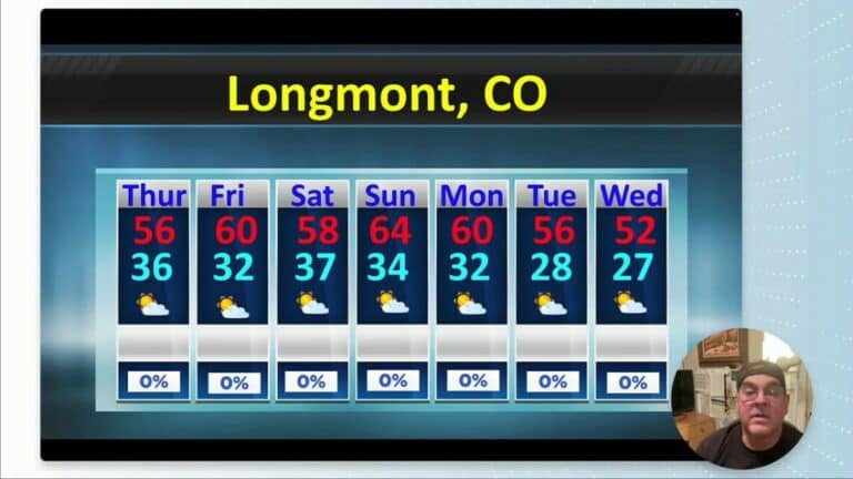
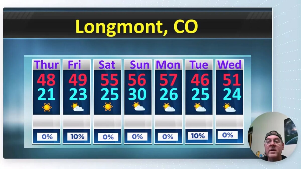
At a glance: what to expect this week
- Temperatures: Mostly above normal. Expect highs in the mid-40s Thursday and Friday, lows in the mid-to-upper teens, then a warm-up into the 50s over the weekend and early next week.
- Precipitation: Very limited. A small trough brings a slight chance of precipitation Tuesday night into early Wednesday (about a 10% to 30% chance depending on the model), but most runs are moisture-starved.
- Winds: No major wind events forecast; Saturday may be a bit breezier.
- Snow: A few light mountain snow events Tuesday, but nothing substantial for the plains.
Snowpack and drought — the numbers to watch
The snowpack picture remains concerning. Current statewide snow water equivalent sits near 58% of median, and precipitation running at roughly 83% of normal. That combination puts most of the state below normal for water resources and shows why a few big, water-filled storms are still needed.
Locally, recent very cold weather produced roughly 1.5 inches of light, low-water snow in Longmont — pretty to look at but not a huge contribution to the water supply.
Why are we so dry? The atmospheric setup
The main reason is a persistent western ridge and a jet-stream boundary that keeps the cold and stormiest air displaced to the east. That ridge over the Intermountain West funnels warmer, drier air into Colorado and prevents Pacific storms from tapping moisture for the Front Range.
When a trough slips through it tends to be moisture-starved — just enough energy for clouds and a sprinkle here and there, but not the big snowmakers we need for the snowpack.
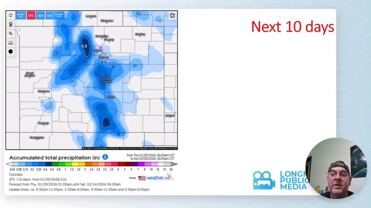
Short-term mountain outlook and 10-day view
Tuesday brings the best, albeit small, chance for mountain snow — mainly light accumulations and short-lived. The Palmer Divide and central mountains might see very minor ripples of snow, but nothing long-lasting.
Ten-day model runs continue to show limited precipitation and a trend toward warmer-than-average temperatures across the West. Even the mountain snowpack can look diminished in those projections if the warm, dry pattern persists.
Air quality and smoke
Air quality is generally good locally. There are a few isolated smoke plumes around the country, but Colorado remains mostly smoke-free for now. The usual pockets in California and the Southeast are the only notable areas of smoke on the maps.
Practical tips for residents
- Water conservation: With snowpack and precipitation below median, reduce outdoor water use where possible and be mindful of winter watering needs for established plants.
- Travel: Light, isolated snow Tuesday in the mountains could mean slippery spots on higher passes. Check mountain road conditions if you plan to travel.
- Enjoy the full moon: February 1 brings a notably large full moon—great for a late-night walk or photos.
- Prepare for quick melts: Warmer days followed by cooler nights can cause freeze-thaw cycles that affect sidewalks and roads. Keep an eye on early morning surfaces.
Records and notable numbers
- Recent forecast highs are running about 10–12 degrees above normal for many days this week.
- Historic extremes to keep in mind: historical record highs and lows for early February show how variable late-winter can be, but the current trend is toward warmth.
Two-week outlook
Looking out two weeks, the signal remains the same: above-normal temperatures and below-normal precipitation. The western ridge wants to reestablish itself after any short-lived troughs, so any relief for the snowpack will likely require a stronger, moisture-rich pattern shift.
FAQ: Will we get significant snow this week?
Not likely. Expect isolated light mountain snow Tuesday and brief flurries at times, but nothing that will dramatically change the snowpack numbers for the region.
FAQ: How low is the snowpack right now?
The statewide snow water equivalent is around 58% of median, with precipitation totals near 83% of normal. Those are low enough to be concerning for spring runoff and water supply without a change in pattern.
FAQ: Should I be worried about drought?
Parts of the state, particularly the northwest, are seeing worsening drought conditions. Widespread drought covers more than half the state. It is sensible to conserve water and pay attention to local drought advisories.
FAQ: When will temperatures return to normal?
Short-term signals point to temperatures staying above normal for the next two weeks. A longer-term return to typical conditions would require sustained changes in the jet stream that bring Pacific storms inland.
Stay prepared, keep an eye on conditions in the mountains if you travel, and enjoy the longer daylight and the full moon at the start of February.