Longmont Weather Report: April 23, 2026 to April 30, 2026
Spring is moving fast across Longmont.
We have gained about 20 minutes of daylight, with sunrise now around 6:08 a.m. and sunset near 7:48 p.m., and it is finally getting noticeable. The sun is already well up on the morning commute, and evenings are stretching out enough that it still feels bright after late meetings.
That seasonal shift is showing up everywhere in this forecast. Temperatures are climbing, severe weather season is beginning to wake up, drought conditions are still worsening, and at the same time there is finally a more active weather pattern trying to move moisture back into Colorado.
That is the big story this week: we need water, and there are real chances to get some.
Table of Contents
- Clear skies, a full moon, and a few things to look up for
- Drought is worsening, but there is at least some hope
- Severe weather season is beginning to ramp up
- The weekly setup: fronts, clouds, mountain snow, and plains storms
- When Longmont has the best chances for rain and thunderstorms
- Why the pattern is changing, and why that matters
- Temperature swings: warm Friday, cooler weekend, then another rebound
- Moisture is returning from the southwest and southeast
- How much precipitation could fall?
- The seven-day outlook for Longmont
- Early May outlook
- What matters most this week
- FAQ
Clear skies, a full moon, and a few things to look up for
Before getting into the forecast itself, there are a few sky notes worth mentioning.
Friday, May 1 brings a full moon, which is easy to remember and easy to spot if skies cooperate.
The sun is active too. Sunspots are rotating into view, and there is an even larger area just around the limb becoming visible in other wavelengths. Some of the visible active regions are already producing X-class solar flares, so the sun is definitely not quiet right now.
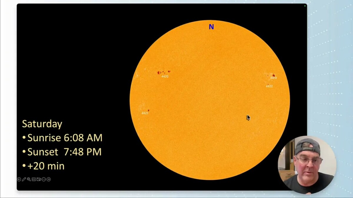
There was also a neat sight from the SOHO solar observatory: Comet PANSTARRS passing between Earth and the sun in coronagraph imagery. In those images, the bright white circle marks the hidden position of the sun, while the surrounding wisps are solar wind. The comet appears close to the sun and may make a brief appearance low in the evening sky over the next few days. If conditions are just right, a hilltop after sunset might give a chance to pick it out near the horizon.
Drought is worsening, but there is at least some hope
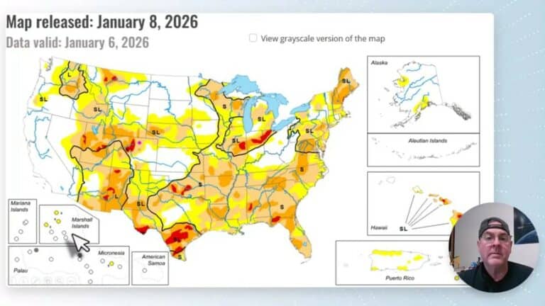
The drought picture is not good.
Conditions have worsened across the eastern plains, with some areas jumping into D2 drought. Nationally, there is a broad axis of worsening dryness stretching from Idaho down toward Louisiana. Colorado is very much part of the problem area, and the simple truth is this: we need water.
There is at least one bit of good news on the fire front. There are fires in Georgia, but nothing significant in the western United States right now, which is a blessing.
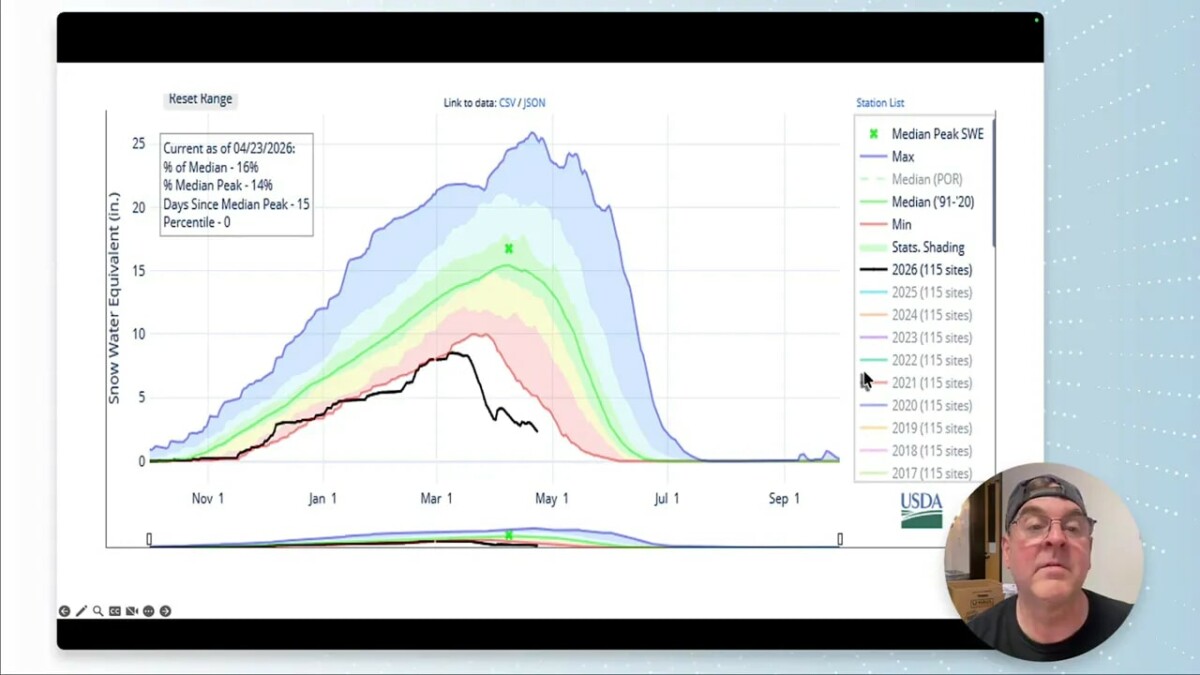
Snowpack remains in rough shape
The snowpack story is still pretty sad. Snow water equivalent has fallen to around 16% of median, which is deep into the ugly part of the chart.
But it is not completely hopeless. The upcoming pattern has enough moisture in it that Colorado could pick up meaningful precipitation, and if that happens, even a struggling snowpack can get a temporary boost before the seasonal melt continues. At lower elevations, there is at least a possibility of up to an inch of precipitation over the next stretch, which would be welcome almost no matter how it arrives.
Recent precipitation has been modest. The northern mountains picked up a little water, and the plains had a touch of snow, but it disappeared quickly.
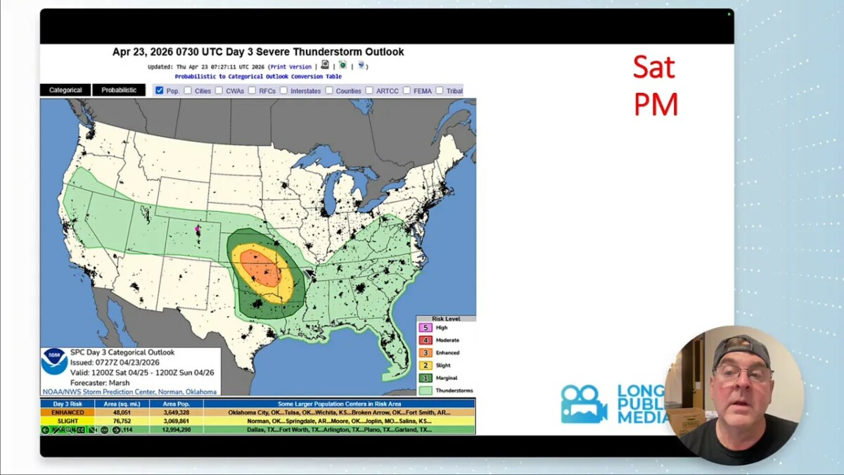
Severe weather season is beginning to ramp up
Late April is when severe weather climatology starts to become more relevant for Colorado, and this week fits that pattern.
Historically, the last week of April brings a slightly elevated risk for severe weather. Along the Front Range, the biggest concern is often hail. Tornado frequency rises much more sharply east of Interstate 25, and the drop-off near that corridor is striking.
This week’s broader severe weather setup places the more active risk areas:
- Thursday: from Oklahoma City up to Minneapolis and even into Canada
- Friday: shifted a bit farther southeast
- Saturday: expanded back toward the northwest
For Colorado, there are also some convective chances closer to home:
- Friday: some storm chances begin
- Saturday: convection possible across much of the state
- Later in the period: marginal severe risk edges back toward northeast Colorado, potentially including areas near Greeley
That lines up pretty well with the seasonal tendency. We are entering the part of spring where the atmosphere starts testing things more often.
The weekly setup: fronts, clouds, mountain snow, and plains storms
The overall pattern is becoming more dynamic.
There is critical fire weather south and east of Colorado, snow north of the mountains, severe weather out on the plains, and a cold front helping to shake things up. Friday looks like a relative break, but by Saturday rain showers return to the northeast, mountain snow picks up again, and the plains remain active.
Normal highs are climbing quickly now, from about 64 to 67 degrees through this stretch, while normal lows rise from 35 to 38 degrees.
It is the time of year when people start thinking about sprinklers, but caution still makes sense. Nights are getting milder, though not reliably warm enough to completely rule out a late freeze. The safe play is still to hold off a bit, especially if the coming rain actually materializes.
Some of the standing records are impressive reminders of how far back the climate archive goes. Record highs near 90 degrees show up around April 30 and May 2, while a record low of 12 degrees reaches all the way back to 1877.
When Longmont has the best chances for rain and thunderstorms
The forecast carries multiple precipitation chances, but a few periods stand out more than others.
The best windows look to be:
- Sunday into Monday
- Wednesday into Thursday
Those periods also come with more cloud cover. Thursday starts quite cloudy, and Sunday and Monday also look cloudier than average as moisture returns.
For individual event totals, the forecast suggests:
- Monday: around a tenth to a quarter inch possible
- Thursday: around a quarter inch, with some areas possibly pushing closer to three tenths
Winds do not appear to be the dominant part of the story. The bigger issue is whether the large-scale pattern can keep feeding enough moisture into the region for showers and thunderstorms to keep developing.
Why the pattern is changing, and why that matters
The atmosphere is finally trying something different.
A trough is taking shape in the western United States, and that matters because Colorado usually needs that kind of setup to improve precipitation chances. The old ridge pattern has been trying to hold on, especially over the eastern U.S. and Great Plains, but a large upper-level swirl digging south into the West is beginning to break that dominance.
The sequence looks roughly like this:
- A western trough digs in through Sunday and Monday
- A reinforcing trough follows into Wednesday
- Northern and southern branches of the flow begin interacting
- Additional ripples ride through the flow into next weekend and beyond
That does not guarantee a soaking rain every day, but it does mean Colorado is no longer sitting under a simple, stubborn dry ridge with no help in sight. Even into early May, the pattern continues to show troughs trying to move through, with the ridge displaced more to the east.
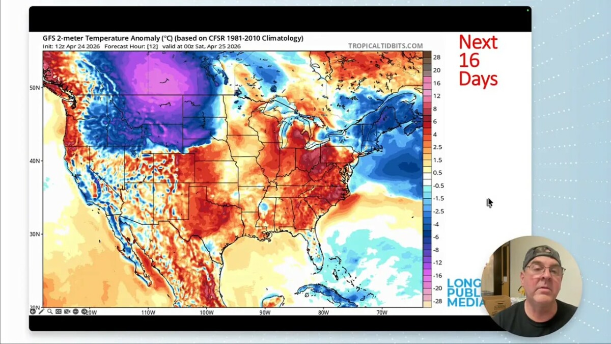
Temperature swings: warm Friday, cooler weekend, then another rebound
Temperature-wise, the setup is classic spring volatility.
A chilly upper low to the north sends some cool air into the region, taking the edge off the warmth and keeping the weekend on the cool side for late April. Cool air lingers into Monday, and much of the West trends below average for a time as the front pushes farther southeast.
Then the pattern tries to rebound. The ridge noses back in around the start of May, bringing warmer temperatures again.
One useful thing to remember this time of year is that thunderstorms can actually show up in temperature guidance. Afternoon storms cool the air beneath them, so when little cool pockets appear in the forecast, that can be a hint that convective development is expected.
By the second week of May, another weak cool front is possible, followed by a reinforcing shot of cooler air. So even as the season advances, spring is not done with its back-and-forth routine.
Moisture is returning from the southwest and southeast
This is one of the more encouraging parts of the forecast.
The atmosphere starts dry, but there is meaningful moisture to the southwest and moisture feeding northward from the Gulf. As the upper low wraps that moisture around, Colorado gets a much better chance of seeing showers and thunderstorms.
The pattern shows:
- Weekend: a healthy push of moisture back into the region
- Tuesday: somewhat drier air briefly returns
- Wednesday onward: moisture climbs again and fills in quickly from both the southwest and southeast
That is exactly the kind of setup that can support repeated rounds of precipitation, especially when upper-level ripples keep moving through.
Dew points are starting to look healthier
At the surface, dew points improve as the week goes on. Around here, once dew points move into the greener shades on the maps, that is good moisture by local standards. It may not seem impressive compared to the central plains, but for the Front Range it is a noticeable improvement.
There is still a bit of a tug-of-war between moist and dry air, and the Front Range can hold onto a narrow strip of drier air for a while. But eventually, the moisture spreads in more fully, and conditions turn fairly humid by local standards.
You may actually start to smell it in the air. And frankly, humidity is better than dust.
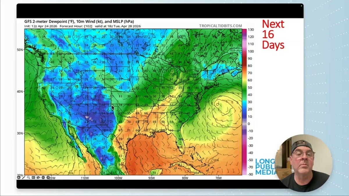
By early May, the moisture does not just flash in and disappear. It tends to linger, with even deeper moisture pooling near the Kansas border at times.
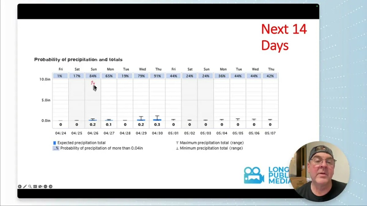
How much precipitation could fall?
The precipitation forecast is active enough to be interesting, though it still comes with the usual spring caution.
The first low throws some precipitation back into the area, then Sunday looks fairly productive on the northwest side of that system. Another batch of scattered showers comes through on Monday, followed by a Tuesday break. By Wednesday, showers return again, with somewhat better coverage farther south.
Looking farther out, the pattern continues to generate additional rounds of mountain showers, afternoon thunderstorms, and new low pressure areas that can toss more moisture back into Colorado around May 9 and May 10.
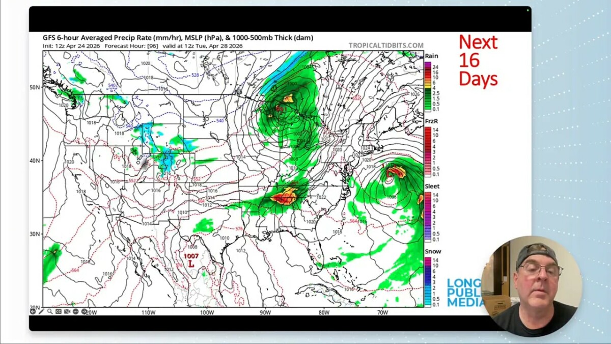
Short-range totals
Over the next five days, the projected totals could add up to something meaningful around Longmont. A third of an inch here, a couple tenths there, and a couple quarter-inch events can accumulate surprisingly well.
That is the kind of week where a dry landscape can at least begin to respond.
Longer-range totals
The 10-day precipitation forecast gets ambitious, showing something like 2 to 2.5 inches around Longmont.
That may be overdone. It may even be outright fiction. But it does speak to how much wetter the modeled pattern is compared to what we have been dealing with. Even if reality only produces a fraction of that, it would still be beneficial.
Mountain snowfall
The mountains could do very well in this pattern. Forecast guidance suggests:
- More than a foot of snow in some mountain areas over the shorter range
- Estes Park: a couple inches on Thursday, perhaps 3 to 4 inches
- Allenspark: perhaps 5 to 6 inches
Extended guidance gets even more aggressive, hinting at 24 to 28 inches in some mountain zones over 10 days. That may be too much, but if even part of it verifies, it would be a welcome late-season boost to snowpack.
The catch is that snow depth guidance also shows much of that snow melting away again within 10 days. That is spring in Colorado. The hope would be to pile some snow back into the high country and then hold onto cooler temperatures long enough for it to linger.
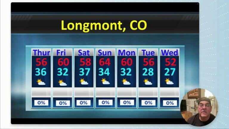
The seven-day outlook for Longmont
Here is the practical day-to-day picture for the week ahead:
- Thursday: 60s to near 70, fairly cloudy
- Friday: warmest day of the stretch, near 80
- Saturday: cooler behind the first cold front
- Sunday: reinforcing cold front, higher chance of thunderstorms
- Monday: continued shower and thunderstorm chances, around 60% range
- Tuesday: daytime break with only a lower chance of late-day showers
- Wednesday: precipitation chances ramp back up
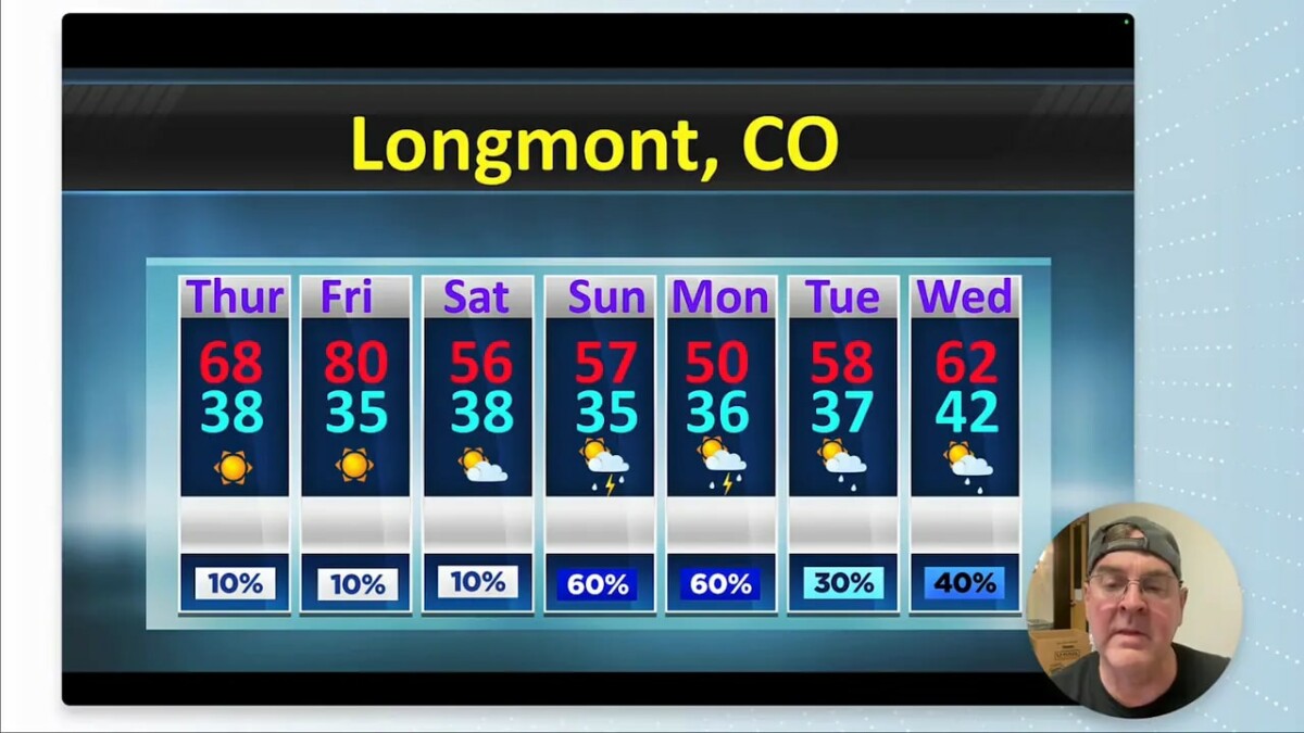
One of the clearest signals in the forecast is the likely pattern of afternoon thunderstorm development, especially Sunday. The probability shading strongly favors storms firing with maximum daytime heating. After that, Tuesday still carries some rain chances, but they look lower, generally around 15 to 20 percent, before the wetter signal grows again from Wednesday into Friday.
Whether those higher-end rain chances hold together remains to be seen. Forecasts like this sometimes look wetter several days out and then shrink back as the event approaches. In drought, forecasters have a saying: when in drought, leave it out. That is a reminder not to count every modeled raindrop before it falls.
Still, even more modest outcomes such as two-thirds of an inch, three-quarters of an inch, or several separate fifth-inch to quarter-inch events over a weekend would be extremely helpful.
Early May outlook
Looking out about two weeks into May, the broader outlook keeps temperatures near normal to slightly cooler than normal.
The April outlook had favored warmer-than-normal conditions with below-normal precipitation overall. That background dryness is still the larger context, but this forecast period at least opens the door to a wetter interlude.
What matters most this week
If there is one headline for Longmont and the Front Range, it is this:
The pattern is finally trying to deliver spring moisture.
Not every storm chance will pay off. Not every precipitation total will verify. Some of the longer-range numbers are probably too generous. But after a worsening drought, a collapsing snowpack, and too much dust, a stretch with repeated chances for rain, mountain snow, and afternoon thunderstorms is exactly what this region needs.
Keep an eye on Sunday, Monday, and the middle to latter part of next week. Those are the windows with the best potential to make a dent.
FAQ
Will Longmont get meaningful rain this week?
There is a decent chance of meaningful precipitation, especially Sunday into Monday and again Wednesday into Thursday. Individual events may only bring a tenth to a quarter inch, but multiple rounds could add up.
Is the drought improving in Longmont and eastern Colorado?
Not yet. Drought conditions have worsened, including expansion of D2 drought on the eastern plains. This forecast offers hope for some short-term relief, but one wet week would not erase the larger deficit.
How bad is the Colorado snowpack right now?
Snow water equivalent has dropped to about 16% of median, which is very poor. Late-season mountain snow this week could help somewhat, but the snowpack remains in rough shape overall.
Is severe weather a concern near Longmont?
Yes, at least to a limited extent. Late April naturally brings a higher risk of severe weather, and northeast Colorado may see marginal severe chances during this pattern. Hail is usually the main concern closer to the Front Range, while tornado risk increases more dramatically east of I-25.
What will temperatures be like in Longmont through April 30?
The warmest day looks like Friday, near 80 degrees. Cooler air arrives over the weekend, with 60s and lower temperatures more common as fronts move through and thunderstorm chances increase.
Should sprinkler systems be turned on yet?
Probably not just yet if you want to play it safe. Nights are getting milder, but a cautious approach still makes sense, especially with possible rain on the way and the lingering chance of a late cold snap.