Deepening Drought – Longmont Weather Report – March 5, 2026 to March 12, 2026
Spring is nudging in with bigger swings: a late-week cold front brings mountain snow and a brief cooldown, then a rapid rebound into warm, dry conditions. Expect light precipitation around Longmont, an uptick in fire-weather risk next week, and a pattern that favors the Midwest for relief while the West stays strained. Below is a clear, practical rundown of what to expect and when to plan for it.
Table of Contents
- Quick snapshot: what to watch this week
- Solar activity and early spring indicators
- Drought, snowpack, and recent precipitation
- This week’s storm: timing, amounts, and impacts
- Severe weather to the south and the dry line threat
- Temperatures and records
- Longer-range pattern and implications
- Practical takeaways
- Frequently asked questions
Quick snapshot: what to watch this week
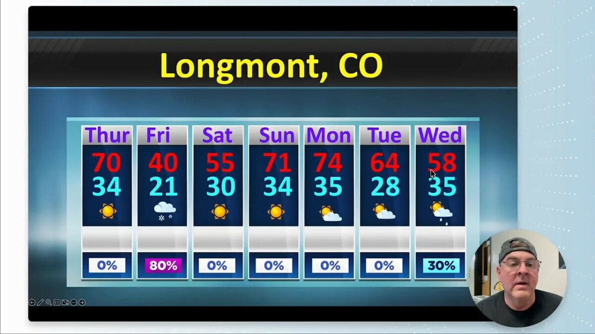
- Short-lived storm Thursday into Friday—mountain snow and light lowland precipitation, roughly a quarter to a half inch in places.
- Cold front timing moves through Thursday (mountains) with the main impact Friday; clearing by Saturday.
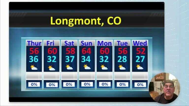
- Temperature swings from 70s (Thursday) down to 30s–40s during the cold surge, then back into the 50s and 70s by the following week.
- Longer-term pattern favors warming and drying over the West after mid-March, raising fire danger and keeping drought concerns in place.
Solar activity and early spring indicators
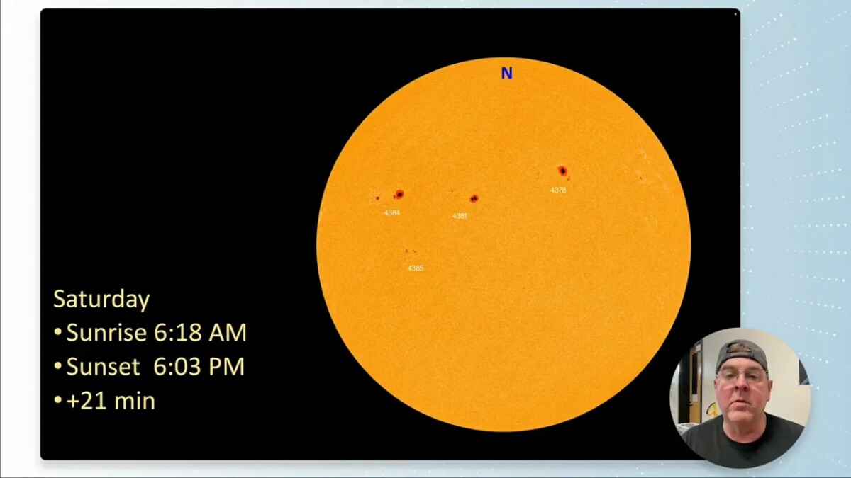
There are three prominent sunspots visible, with one growing that could enhance northern lights activity if conditions align. Also worth noting: we gained about 21 minutes of daylight compared with last week—classic early-March progress toward longer days.
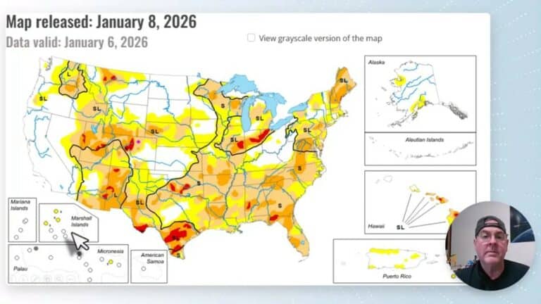
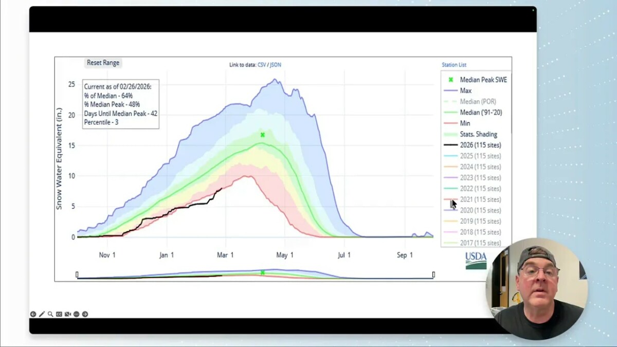
Drought, snowpack, and recent precipitation
Regional drought has worsened. Areas just south of Longmont are now in extreme drought, and drought coverage has expanded across the mountains and the upper Midwest. February outlooks expected relief for the Midwest and Great Lakes; that relief is happening there, but the western drought remains stubborn.
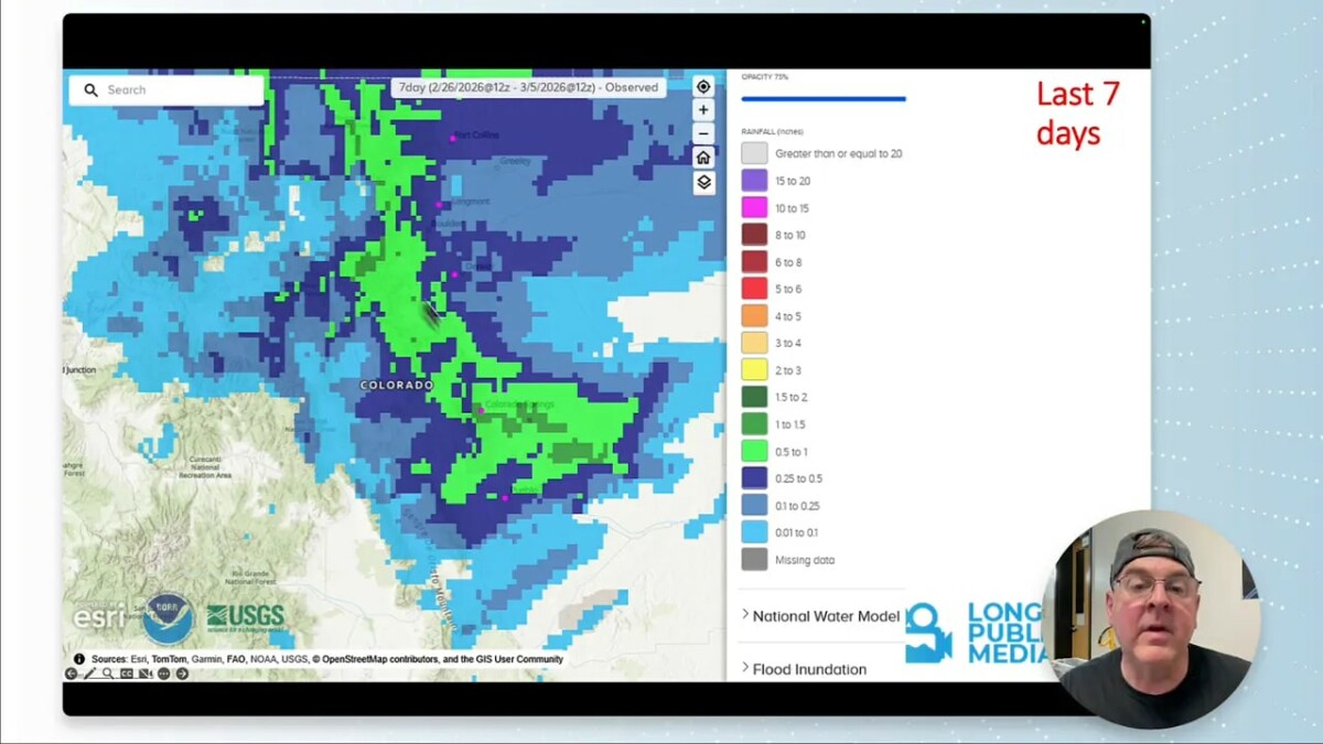
Recent precipitation was light. Friday’s lowland totals were generally around a quarter inch, with pockets up to a half inch and some mountain locations seeing higher amounts. Current water metrics:
- Reservoir/stream water content roughly 81% of normal.
- Snowpack water content near 61% of normal.
This week’s storm: timing, amounts, and impacts
A trough and cold front swing down out of Wyoming Thursday, producing mountain snow ahead of the front. The lowland precipitation on Friday is light and may switch to rain in the afternoon, which will limit accumulation on roads. Expect heavier pockets of snow in the high country and mostly light precipitation across the plains.
Model guidance (GEM and others) suggests the next 48 hours will deliver about 0.25–0.33 inches liquid equivalent around Longmont and the surrounding foothills, with higher totals on the western slopes. After Friday the system moves away and the region returns to drier conditions.
Severe weather to the south and the dry line threat
Severe storms will be focused in the southern Plains—Tornado Alley and the Texas/Oklahoma panhandle—where a strong dry line sets up and moisture wraps into the storms. For our area, the main concern is just distant: thunder south of Longmont on Friday is possible, but severe weather is expected well to the south and east.
Temperatures and records
Normal daytime highs for this period are climbing from the low 50s into the mid 50s. Expect:
- Thursday: highs near 70°F before the front drops temperatures.
- Friday into Saturday: highs tumble into the 30s–40s depending on snow intensity.
- Early next week: a quick rebound to the 50s–mid 70s by Monday, then another small cooldown midweek.
Historical notes: record highs around 79°F occurred on March 10–11 and March 15 in past years, while a sharp cold in March 1880 reached about -10°F on the 13th and 14th. This week’s swings are significant but not record-breaking.
Longer-range pattern and implications
After this brief trough and frontal passage, the jet stream flattens into a zonal flow and then re-establishes a western ridge. The ridge-era pattern typically brings:
- Warming and drying across the West.
- Reduced chances for large, sustained precipitation events.
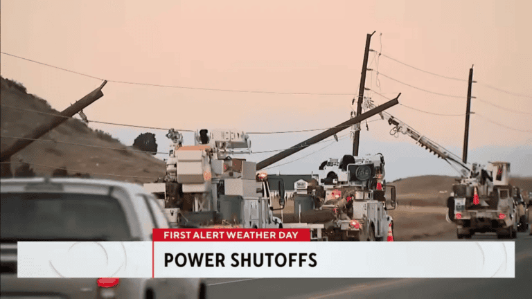
- Increased fire-weather risk if winds pick up and vegetation remains dry.
Two-week guidance leans warmer than normal for the region, with roughly equal chances for significant moisture—meaning uncertainty remains, but the bias favors dryness.
Practical takeaways
- Plan for light travel impacts in the mountains Friday; lowland roads should remain mostly fine unless localized heavier snow develops.
- Keep an eye on wind forecasts mid to late next week—fire danger could rise.
- Water resource outlook remains a concern. Any significant pattern change bringing sustained moisture would be beneficial.
Frequently asked questions
Will Longmont see significant snow this week?
Not likely. Mountains will see the bulk of the snow Thursday into Friday. Lowland Longmont and the plains should see light precipitation—generally a quarter inch and in places up to a half inch—possibly switching to rain Friday afternoon.
Is severe weather expected locally?
Severe weather is expected mainly in the southern Plains along the dry line. Locally, a few thunderstorms south of Longmont on Friday are possible, but widespread severe storms are not anticipated here.
How is the drought and snowpack looking?
Drought has deepened, with extreme drought just south of Longmont and expanded coverage across mountain and upper-Midwest areas. Snowpack water equivalent is below normal (around 61%), and short-term precipitation this week provides only modest relief.
Should I worry about fire danger next week?
Yes, monitor conditions. After a brief cool-down the pattern favors warming and drying, and winds are expected to pick up mid to late next week, which could elevate fire risk.
Any notable astronomical events?
The third quarter moon is in the morning sky on March 3, and growing sunspot activity could enhance auroral chances if geomagnetic activity increases.