Longmont Weather Report – December 11, 2025 to December 27, 2025
Will there be snow in Longmont for Chrimstmas? Possibly. Here’s a two‑week outlook for Longmont and the northern Colorado mountains and a drought, precipitation, and snowpack analysis.


Expect a mostly quiet stretch through mid December with unusually mild temperatures early in the period, followed by a growing chance for colder air and a significant storm arriving around Christmas. Confidence is low for details beyond about seven to ten days, but the pattern signals a real winter flip between December 22 and the last week of the month.
Table of Contents
- Quick snapshot: what’s happening now
- Snowpack and precipitation summary
- Short‑term outlook: next 5–10 days
- Two‑week model pattern: what to watch
- Christmas period: a real shot at winter weather
- Key points to keep in mind
- Frequently asked questions
Quick snapshot: what’s happening now
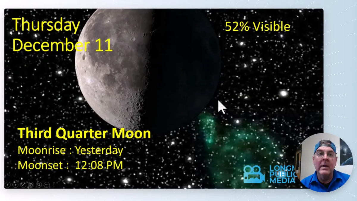
The moon phase is third quarter in the morning sky and daylight is closing in on its seasonal minimum.
Sunset is near 4:36 p.m., and daylight minutes are still decreasing by several minutes per week.
A large set of sunspots passed by without producing any notable geomagnetic activity.
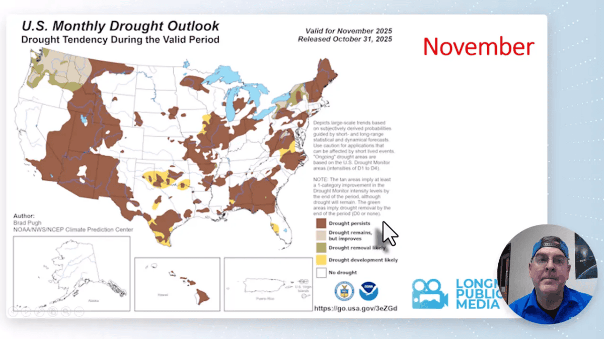
Drought conditions remain largely unchanged statewide, with only modest relief in the higher terrain after recent mountain snowfall.
Out west, an atmospheric river is set to slam into the Pacific Northwest, producing heavy rain, deep mountain snow, flooding, and elevated avalanche danger there. That influx of moisture will mostly spare Colorado in the short term but will remove drought from parts of Washington and Oregon.
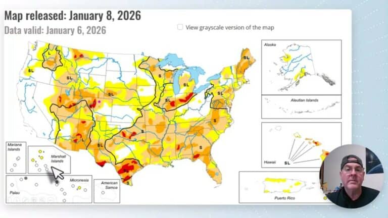
Snowpack and precipitation summary
Mountain snowpack has improved but remains below typical levels for this time of year—about 72% of normal in the broader snapshot shown here. Precipitation totals averaged across the region are running at roughly 105% of normal in places that did receive recent storms. The bulk of measurable precipitation has fallen in the northern mountain zones rather than the front range or plains.
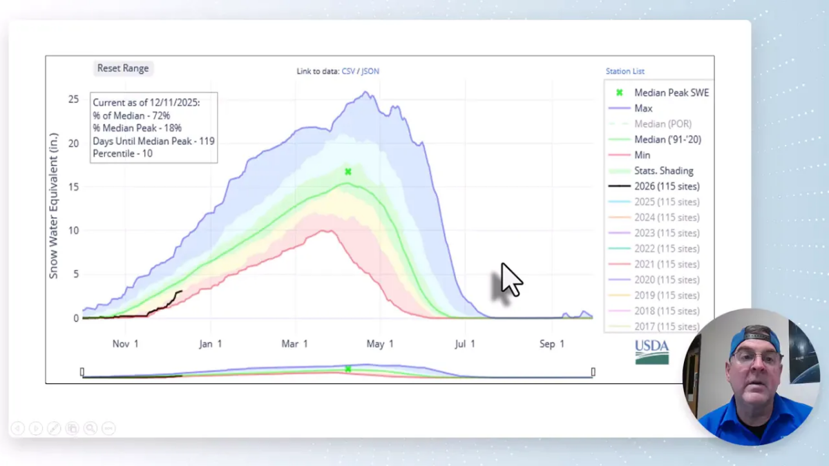
Recent mountain additions were enough to bump totals, but melting and limited accumulations at lower elevations mean the drought picture only nudged toward improvement. When thinking about water content, remember the maps are often showing liquid equivalent; high mountain totals translate to several feet of snowfall in the highest terrain, but less in the valleys.
Short‑term outlook: next 5–10 days
The immediate forecast is dominated by a northwest to southeast river of moisture across the northern tier, keeping the Pacific Northwest active while Colorado sits on the warm, dry side of a boundary. Expect mostly sunny days with a few thin cloud bands. Precipitation chances for the plains are near zero for the next five days and remain very low through much of the following week.
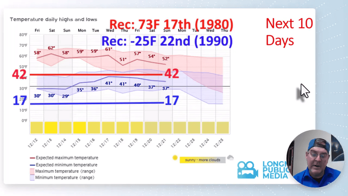
Typical highs this time of year run near 42°F and lows near 17°F. Temperatures in the next week will generally run above those normals, with a few days pushing well into the 50s and even near 60°F across lower elevations. Record extremes for the period: a modern record high near 73°F and a recent record low down around -25°F.
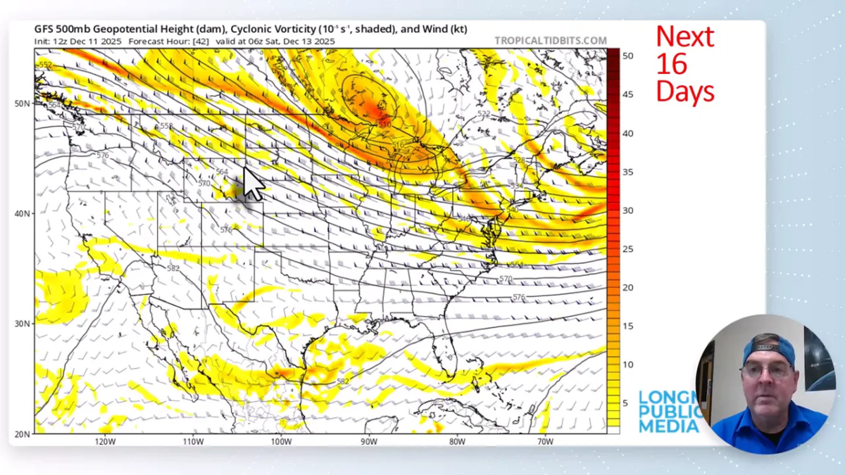
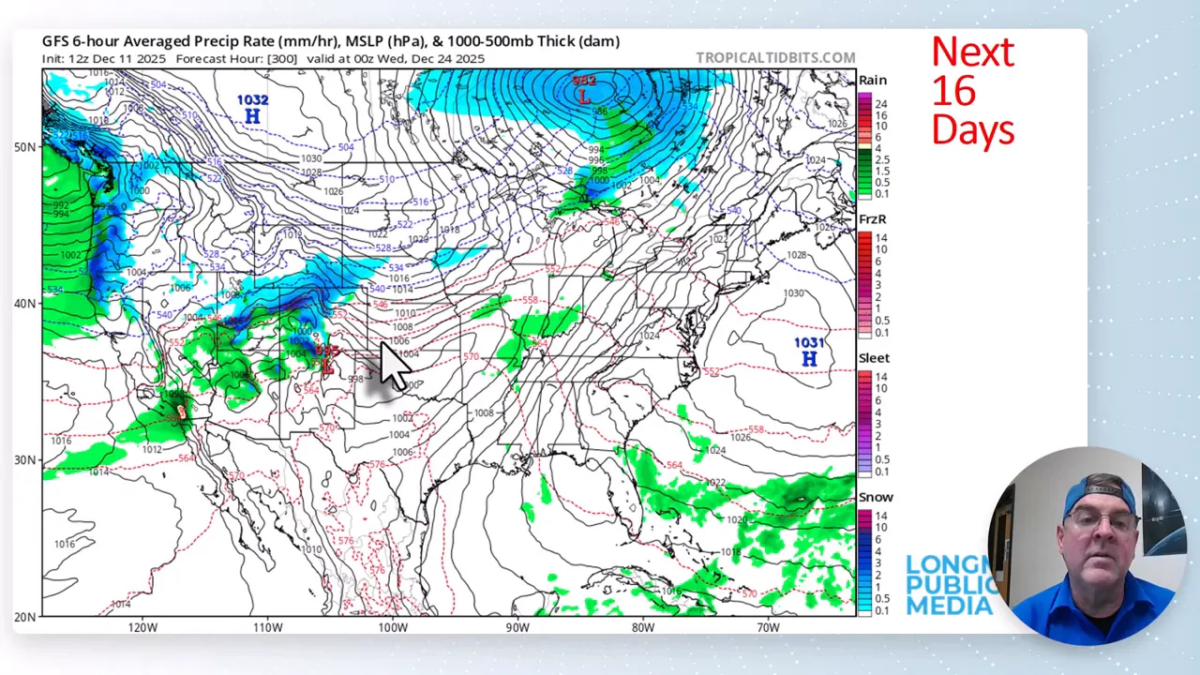
Two‑week model pattern: what to watch
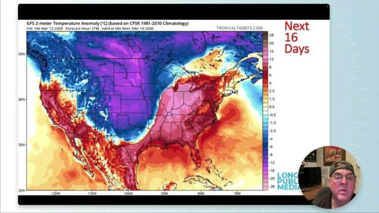
Long‑range model output shows a strong ridge rebuilding over the western U.S. through mid December, which boosts temperatures substantially above normal for several days. That ridge keeps Colorado relatively quiet until a deeper trough is progged to dig into the West around December 22.
When that trough pushes east it can drive a cold front and produce upslope snow for the Front Range foothills and adjacent plains. After the initial push there is another, even deeper trough hinted at arriving between Christmas and New Year, which would bring a more prolonged period of colder air across the western United States.
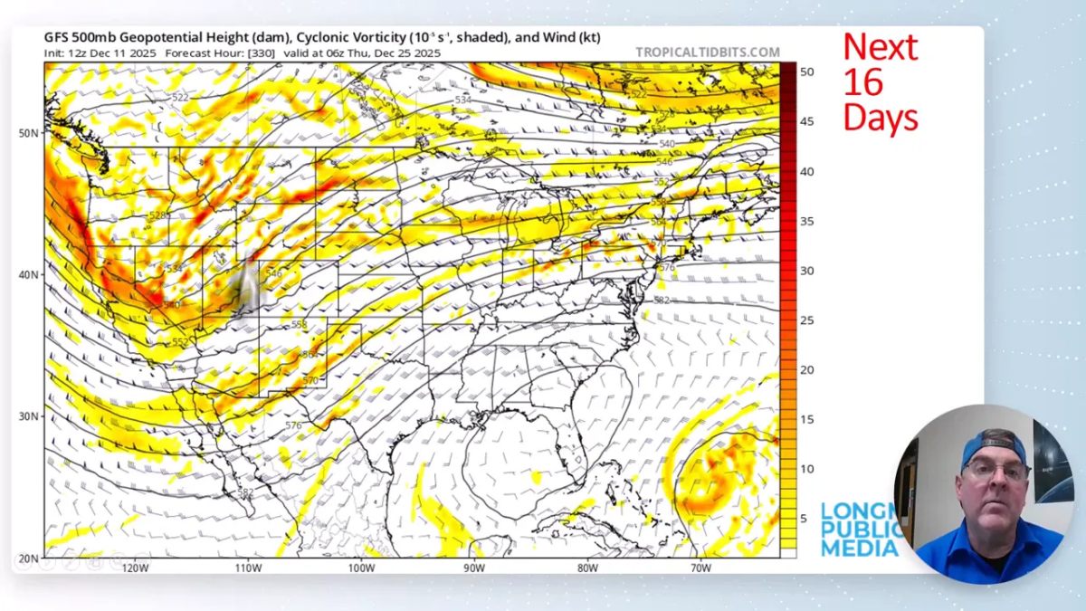
Confidence in exact timing and amounts remains limited this far out. Models oscillate between a storm on the 23rd, 24th, 25th, or 26th, so expect the target window to shift by a day or two as we approach the event.
Christmas period: a real shot at winter weather
The most notable takeaway from the two‑week projection is the growing chance for a meaningful winter event in the Christmas to New Year’s window. Model runs repeatedly show large precipitation totals on the western slopes that would spill eastward and clip northern Colorado at times.
Current guidance indicates a liquid precipitation signal near 0.8 inches for parts of northern Colorado if the system verifies—roughly translating to 6 to 8 inches of snow in areas that get cold enough for efficient snow ratios. Right now that translates to about a 60% chance of measurable snow across the region on or around Christmas Eve and Christmas Day, but the exact timing could slide several days earlier or later.
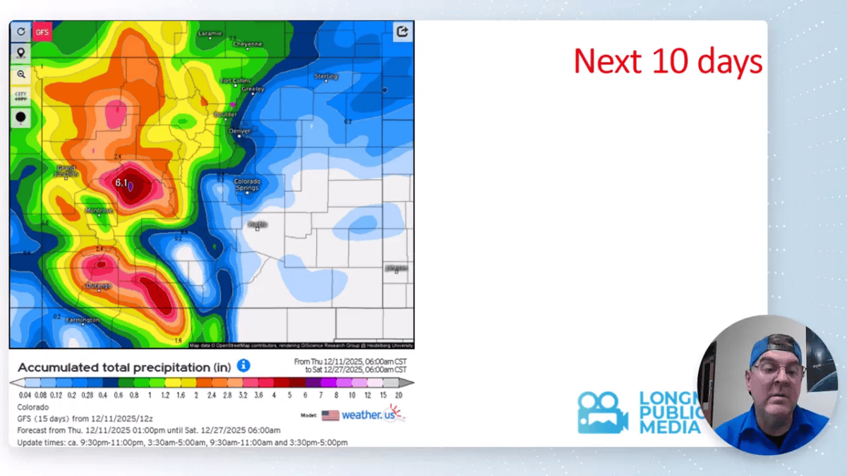
If the trough digs deeper than currently modeled, colder air will follow and the event could become more wintry across lower elevations. If the system trends faster or weaker, precipitation may miss to the north or stay focused on the high western slopes.
Key points to keep in mind
- Short term: Mostly dry and well above normal temperatures for the next week.
- Snowpack: Improved in the mountains but still below typical for this date overall.
- Pacific Northwest: Facing significant atmospheric river impacts; expect flooding, heavy snow in high terrain, and avalanche concerns there.
- Late December: Increasing potential for a real winter storm and colder air between December 22 and the week after Christmas. Details will change as models update.
Frequently asked questions
Will we get snow for Christmas?
There is a reasonable chance of snow around Christmas Eve through the 26th. Current model ensembles put the probability near 60 percent for measurable snow, with timing that could shift by a day or two. Expect more certainty in the 3–7 day window before the event.
How much snow could fall if the storm verifies?
If the model signal holds, liquid equivalent near 0.8 inches translates to roughly 6 to 8 inches of snow in places that remain cold. Mountain locations could see significantly higher totals; valley and plains totals will depend on how quickly colder air arrives.
Are there any severe weather threats?
No widespread severe thunderstorm threats are expected locally over the next week. The main severe concerns are Pacific Northwest impacts from the atmospheric river, including flooding and mountain avalanche risk.
How confident are these long‑range model forecasts?
Confidence is moderate for the overall pattern: a warm, dry stretch through mid December followed by a trough that could bring colder air and precipitation late in the month. Confidence in exact timing and snowfall amounts is low beyond 7–10 days; expect updates as ensembles and operational runs converge.
What should I prepare for now?
Enjoy the mild and dry spell while it lasts, but monitor forecasts closely from December 20 onward in case the late‑month storm sharpens up. Vehicle winter checks, stocking basic snow supplies, and being ready for changing travel conditions are sensible steps.
As one meteorologist put it, enjoy the weather—it’s the only weather you have. Keep an eye on updated guidance through the next two weeks and plan for adjustments as the pattern evolves.