Record Heat, Expanding Drought: Longmont Weather Report (March 19 to March 26, 2026)
Here is the big takeaway for Longmont and the Front Range as we head through March 19 to March 26, 2026: the pattern is locked in. A powerful ridge of high pressure dominates the West, pushing temperatures well above normal, while precipitation stays scarce. The forecast is not just “dry.” It is the kind of dry that keeps stacking the deck for drought.
If you feel like “drought” is showing up everywhere lately, you are not imagining it. And if you think that word should come with a warning label, you are also not alone.
Table of Contents
- High Pressure Wins: Why the Week Turns Hot and Dry
- Drought Outlook: Progress Stalls, and the Hot Pattern Adds Fuel
- Rain Chances: Single Digits Through the Stretch
- Temperature Timeline: Record Heat Likely in This Window
- Wind and Fire Weather: Elevated, Ongoing Concern
- Mountains and Snow: Little Signal for Meaningful Accumulation
- What About Storms Away From Us?
- Extra Note: Aurora Watch With Space Weather
- Practical Takeaways for Longmont (This Week)
- FAQ
- Bottom Line
High Pressure Wins: Why the Week Turns Hot and Dry
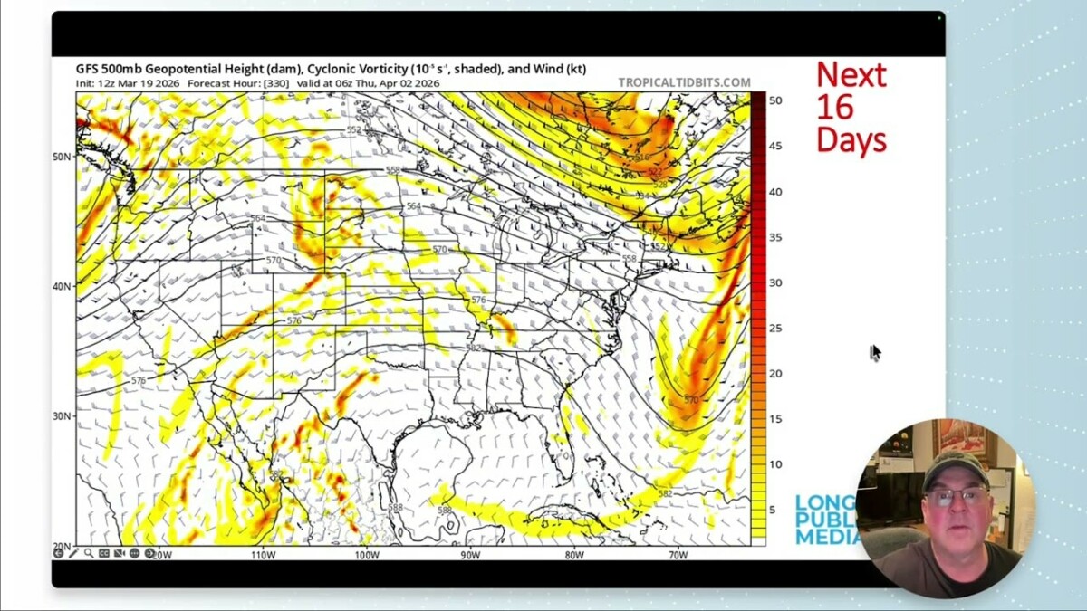
The weather driver is a record-breaking, powerful high parked over the region. On satellite and model guidance, you can see the ridge sitting there like a lid. Even when shortwaves try to nudge the pattern, the high never fully backs out.
One small cool down briefly shows up around Sunday into Monday as a cool front slides through, but it does not have the strength to deliver real rain or a sustained weather reset. After the weekend, the ridge reasserts itself and temperatures climb again.
In practical terms for Longmont, expect a cycle of:
- Friday and Saturday building toward the hottest stretch
- Sunday into Monday a short, modest cooldown
- Midweek and beyond back into the 90s
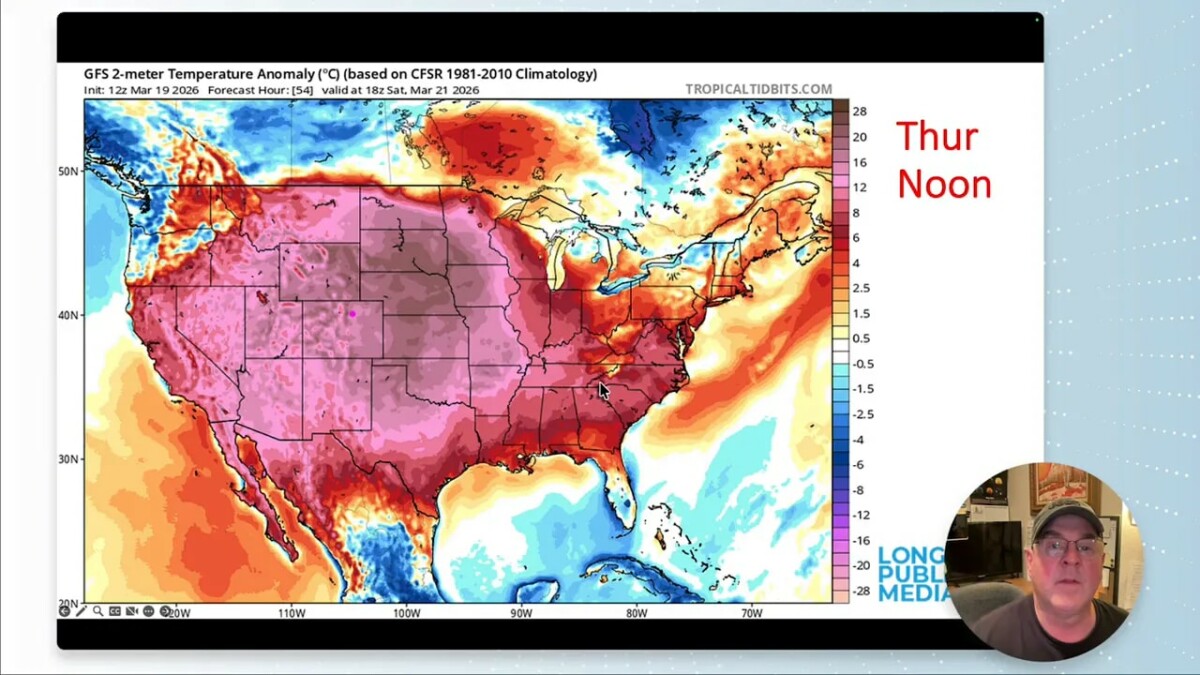
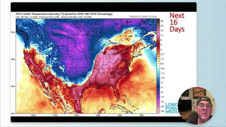
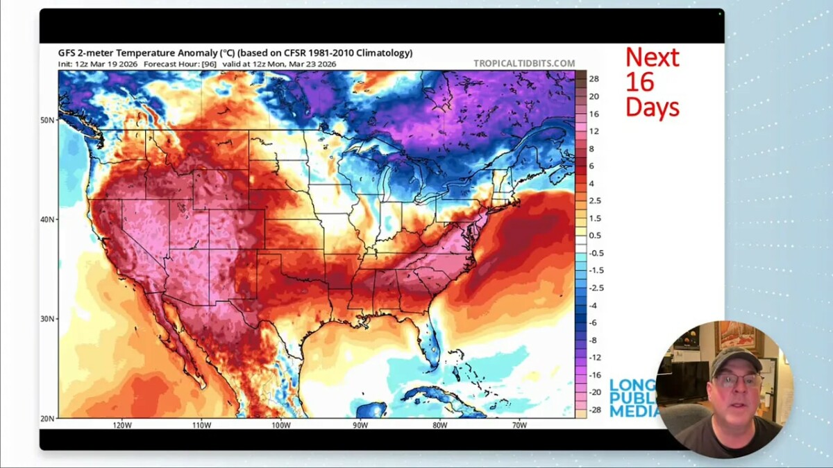
Model temperature departures from normal are described as extreme, with values around 35 degrees above normal at points. That is part of why this feels less like “late March weather” and more like a pattern you usually associate with deeper summer.
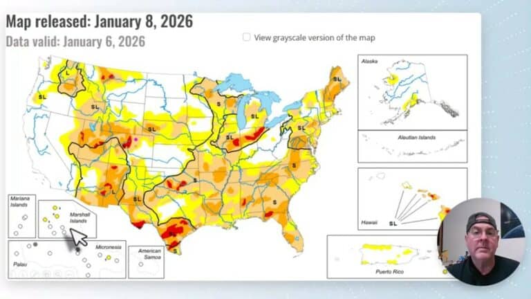
Drought Outlook: Progress Stalls, and the Hot Pattern Adds Fuel
Nationally, drought signals are expanding in places that are already stressed. The forecast discussion highlights increasing drought risk in:
- Arizona
- Interior Mountain West
- Great Basin
- Other nearby western dry zones
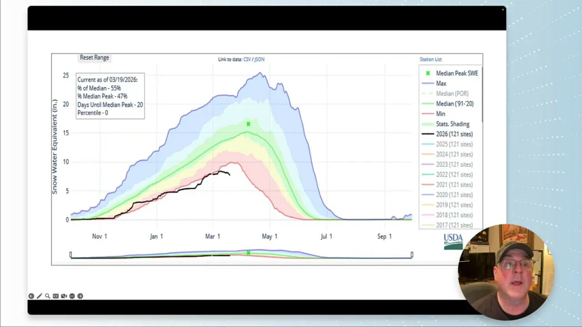
For Colorado specifically, the pattern is more uneven. Northern Colorado did not get noticeably drier, but southern Colorado mountains and plains did. That matters because it is the mountain snow and downstream moisture supply that often helps buffer the whole state later.
According to the drought indicators cited in the forecast update:
- Peak median percent around 55% (not good)
- Snowpack water equivalent in record low territory
- Precipitation hovering around 80% of the median (back “in the red”)
What little precipitation we had did not last
There was some moisture in the prior week, including a very cold day and a light snow signal near Longmont (about half an inch mentioned), plus a few inches reported in South Denver. But it is described as gone now, which is a common theme when the air mass turns dry and warm.
Rain Chances: Single Digits Through the Stretch
When a ridge dominates, it can suppress storm formation. That is exactly what is expected here. The forecast calls for percent chances of rain in single digits at least out through the coming 10 days.
For many locations, that means dry days with minimal cloud cover, and only brief attempts at weather systems that do not bring measurable benefit.
Even where there are fronts draped near the Canadian border with some snow in northern areas, the cool air does not have the moisture and momentum to produce the kind of precipitation Colorado needs.
Temperature Timeline: Record Heat Likely in This Window
The forecast is confident about hot highs, with a very clear expectation for the hottest values on Friday and Saturday.
- Thursday into Friday: warming quickly
- Friday: around 88, with the possibility of 90+
- Saturday: definitely breaking 90
- Sunday into Monday: a brief dip into the 60s and 70s
- Midweek after that: temperatures climbing again back into the 90s
There are also specific record anchors mentioned for the period:
- 84 on March 26, 1971 as a monthly record high
- -11°F on March 28, 1886 as a monthly record low
So yes, this is a week where both ends of the spectrum show up in historical context. The atmosphere will likely behave more like the record high side.
Wind and Fire Weather: Elevated, Ongoing Concern
Heat is not the only issue. The forecast also flags wind and fire danger as elevated.
In general terms, stronger winds and dry fuels can raise risk even without lightning or widespread rainfall. The forecast notes:
- Elevated fire danger every day in the window
- Periods of stronger winds, especially when the pattern tightens behind boundaries
In the larger-scale pattern, jet stream and high pressure dynamics are described as steering energy north and over the region, with closed high circulation centered to the southwest. That kind of setup frequently supports dry air and windy stretches on the margins of systems.
Mountains and Snow: Little Signal for Meaningful Accumulation
One of the most important questions for drought in Colorado is whether we can rebuild mountain snowpack. The forecast outlook offers very limited snow potential in the mountains during this period.
The discussion includes:
- New snowfall only in small zones near the Wyoming border for about the next five days
- Only “little spots” of mountain precipitation farther out
- By around day 10, the snow signal diminishes
There is also an important note about uncertainty: the snow depth product mentioned is only seen from one model output location, and accuracy is not guaranteed. Still, the broad message aligns with what the ridge pattern usually does: it suppresses storms capable of reliable snowfall.
What About Storms Away From Us?
Thunderstorms are possible somewhere in the country, but the pattern is not centered on Colorado.
The forecast notes:
- Thursday: no major thunder mentioned for Colorado
- Friday: a marginal or moderate risk in the Ohio Valley area
- Great Lakes and South: thunder possibilities appear farther away
Meanwhile, the broader front structure stays mostly draped near the Canadian border, and the ridge underneath continues to dominate what happens in Colorado.
Extra Note: Aurora Watch With Space Weather
Because the atmosphere has multiple layers of “stuff” happening at once, there was also mention of solar activity. The sun is described as mostly quiet except for a spot producing coronal mass ejections.
That raises the possibility of aurora, especially on Thursday, Friday, and Saturday nights. For updates, the suggestion is to check:
spaceweather.com
Practical Takeaways for Longmont (This Week)
- Expect dry conditions and plan around very low rain chances.
- Prepare for rapid warming and potentially record-breaking heat Friday and Saturday.
- Take fire danger seriously, particularly during windy periods.
- Remember drought impacts are cumulative, not just one storm at a time.
- For mountain moisture hopes, the signal is limited in this timeframe.
FAQ
Will Longmont get rain during March 19 to March 26?
The forecast emphasizes single-digit chances of rain through at least 10 days, with 0% precipitation mentioned through much of the stretch after midweek temperature climb.
How hot is it expected to get?
Temperatures are expected to reach the upper 80s to around 90+ on Friday and definitely break 90 on Saturday, then dip briefly into the 60s and 70s Sunday and Monday before warming again into the 90s.
Is drought worsening in Colorado?
Drought indicators are described as problematic, with southern Colorado mountains and plains getting drier, while northern Colorado was less affected during the latest changes. Overall, the hot and dry pattern supports worsening conditions.
What is the main weather pattern driving this forecast?
A stationary, record-strength ridge of high pressure over the West keeps suppressing storms. Even when fronts briefly cool things down, the ridge largely returns and strengthens again.
Is there any meaningful snowfall in the mountains?
Only small or localized mountain signals are mentioned, with the snow forecast described as limited and diminishing by about day 10. There is also uncertainty noted in the snow depth product, but the overall pattern does not favor significant accumulation.
Could we see auroras?
Solar activity is described as producing coronal mass ejections, making auroras possible, especially on Thursday, Friday, and Saturday nights. Check spaceweather.com for updates.
Bottom Line
If moisture is what you are hoping for, this week is not the one that delivers it. The ridge is strong, the rain chances are low, and temperatures are primed for a warm to hot stretch with record potential. In the meantime, the drought story continues to build, and the best you can do is plan for dry conditions while keeping an eye on any front that might finally break the pattern.
Keep looking up. And if you find moisture someplace, let it count.