Why Does Colorado Get Hurricane Force Winds in the Winter?
In mid December 2025, Hurricane-strength gusts battered Colorado’s front range, Boulder County, and parts of the high country. Warm, dry conditions coupled with an intense airflow over the mountains created a perfect setup for wildly variable, powerful winds — winds strong enough to trigger power shutoffs, close highways, delay flights, and dramatically raise fire danger.
Here’s What the News Looked Like in December 2025
Key impacts to know:
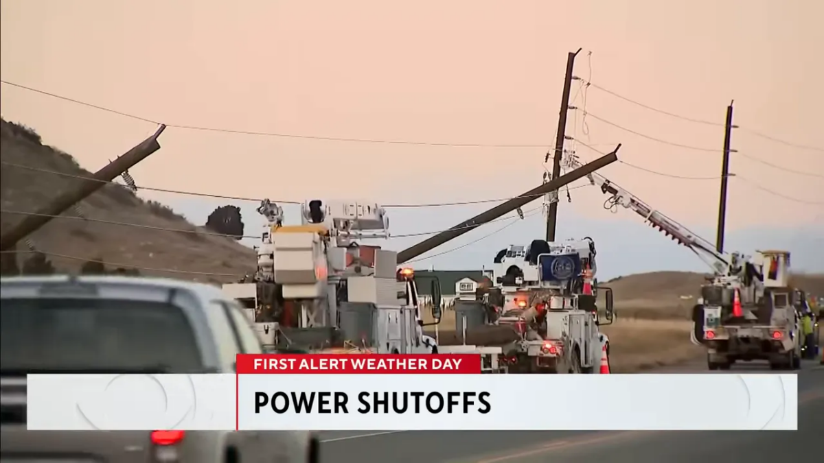
- Tens of thousands of customers are without power after utilities initiated planned shutoffs and unplanned outages.
- XL Energy ordered targeted power shutoffs to reduce wildfire risk; some areas may be without power for days.
- Road closures include Highway 93 between Golden and Boulder and US 287 between Ted’s Place and the Wyoming border.
- Denver International Airport issued a ground delay because of the high winds.
- High fire danger across the region due to warm, dry air and strong winds.


What causes these extreme gusts in Colorado’s Front Range?
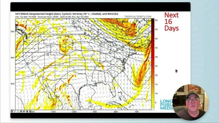
Here’s the scenario: A tight, strong flow in the upper atmosphere is moving over the Rocky Mountains. Where that fast-moving air crosses the topography, it generates a phenomenon called a mountain wave.
Imagine a blob of air riding that wave: on the downstream side of the range it can suddenly be forced downward and compressed, accelerating to very high speeds when it reaches lower elevations.
There’s also a pronounced jet max overhead — a localized pocket of especially fast winds aloft. When this is happening, you can actually see it in the clouds racing due east. When that jet max lines up with the terrain, it amplifies the mountain-wave effect and produces very sudden, sporadic gusts at the surface.
Why the gusts are so unpredictable
Mountain-wave-driven winds are inherently patchy. A neighborhood can be calm one minute and experience a damaging gust the next. Stability changes with height, so an air parcel that’s stable over a ridge can become unstable as it descends, producing a sudden, powerful burst of wind in a concentrated area. That explains reports of dramatic, localized impacts — broken windows, downed poles, and abrupt power loss — even when nearby locations seem relatively quiet.
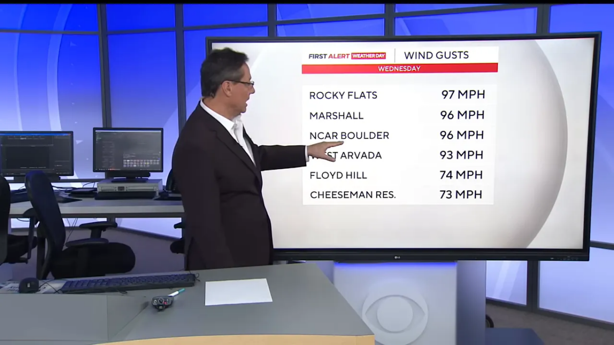
How strong do the Boulder area winds get?
Observed peak gusts have been startling:
- Rocky Flats: 97 mph
- Marshall area: 96 mph
- MESA Lab (Boulder): 96 mph
- West Arvada: 93 mph
- Floyd Hill: 74 mph
- Cheesman Reservoir: 73 mph
Winds at or above 74 mph are considered hurricane strength. Forecasts showed gusts continuing to ramp up across foothill communities, with the potential for additional 70–90+ mph bursts in exposed locations as the strong flow persists.
Five Reasons for Hurricane Force Winds in Colorado Decembers
1. Strong Pressure Gradients After Winter Storms
In winter, powerful cold fronts frequently sweep across the central U.S.
- High pressure builds rapidly over Wyoming and the northern Rockies behind these fronts.
- Lower pressure remains to the south and east (eastern Colorado and the Plains).
- Air accelerates from high to low pressure, producing sustained high winds.
Because Colorado sits immediately east of major mountain barriers, these pressure gradients can be unusually steep, allowing winds to reach 75–100+ mph in exposed areas.
2. Chinook Winds (Downslope Warming and Acceleration)
One of the most important contributors is the Chinook wind, a type of downslope wind.
- Westerly winds cross the Rockies.
- As air descends the eastern slopes, it compresses, warms, and accelerates.
- This process can dramatically increase wind speed near the foothills and adjacent plains.
These winds are strongest in winter when upper-level winds are faster and more persistent.


3. Mountain Wave Amplification
Under the right conditions, air flowing over the Rockies forms mountain waves, similar to waves in water.
- Strong winds aloft + stable air = large atmospheric waves.
- These waves can break near the surface, transferring high-altitude momentum downward.
- When this occurs, surface winds can suddenly spike to hurricane force.
This is why gusts often appear suddenly and locally, even on otherwise clear days.
4. Jet Stream Positioning
During winter, the polar jet stream often passes directly over or near Colorado.
- Jet stream winds can exceed 120–150 mph at altitude.
- If atmospheric conditions allow vertical mixing, some of that momentum reaches the ground.
- This is most common east of the mountains, where terrain funnels airflow downward.
5. Topographic Funnel Effects
Colorado’s terrain further intensifies winds:
- Mountain passes, valleys, and gaps act as natural wind tunnels.
- Areas such as Boulder, Golden, Colorado Springs, and the Palmer Divide are especially vulnerable.
- The High Plains east of the Front Range offer little surface friction to slow winds once they descend.
Why It Happens Mostly in Winter
Winter provides the ideal combination of:
- Stronger jet stream winds
- Larger temperature contrasts
- More intense pressure systems
- More stable air masses that support mountain wave formation
Summer storms may produce brief gusts, but winter conditions allow long-lasting, widespread wind events.
Why this raises the fire danger
Warm, dry air plus strong winds is the worst combination for fire spread. Even a small ignition can become large quickly when gusts are erratic and strong. Utilities may preemptively shut off power to reduce the chance of equipment starting a wildfire — a disruptive but effective strategy to lower immediate risk.
Colorado’s hurricane-force winter winds are not caused by tropical systems. They are a product of mountain meteorology, pressure gradients, and atmospheric dynamics unique to the Rockies and the High Plains. Several mechanisms often act together.
In Summary
Colorado experiences hurricane-force winter winds because it sits at the intersection of:
- Powerful winter pressure systems
- The Rocky Mountains’ downslope dynamics
- Jet stream energy
- Terrain that amplifies airflow
The result is some of the strongest non-tropical winds regularly observed anywhere in the United States.
Practical Safety Steps
- Prepare for outages: Gather flashlights, batteries, a charged phone power bank, water, and nonperishable food. Keep refrigerators and freezers closed as much as possible.
- Secure outdoor items: Bring in patio furniture, trash cans, and any loose objects that can become projectiles in high winds.
- Avoid closed roads: Do not attempt to travel on highways that have been shut down. High-profile vehicles are at risk in sustained crosswinds.
- Stay away from downed lines: Assume any fallen power line is live. Report it to the utility and keep a safe distance.
- If you must drive: Slow down, keep both hands on the wheel, and be alert for sudden gusts and debris.
- Protect against fire risks: Avoid any outdoor burning, follow local burn restrictions, and obey utility and emergency agency instructions.
Bottom line
What can happen in the Boulder area in December is that strong upper-level winds interacting with Rocky Mountain terrain produce powerful, highly localized gusts along the front range and higher elevations. Those winds, combined with warm, dry conditions, increase wildfire risk and have led to power shutoffs, transportation impacts, and airport delays.