Why Has it Been So Warm? Longmont Weather Report – January 1, 2026 to January 8, 2026
The first week of January was unseasonably warm and mostly dry for Longmont, while the mountains got some snow. There was a bright full moon and a chance of aurora after a coronal mass ejection, but on the ground it is drought watch time: snowpack is flirting with record lows and overall precipitation is below normal.
Temperatures have been well above the January average with a persistent ridge of high pressure that was keeping things mild through much of the week.
Table of Contents
- Quick overview: what matters this week
- Moon, space weather and a chance of aurora
- Drought and snowpack: the story is worrisome
- Why it’s so warm: a persistent ridge
- Precipitation outlook: mountains get the most
- Temperatures, winds and short-term hazards
- Mountains vs plains: different winters nearby
- Longer-range signals and wild-card possibilities
- Actionable takeaways
- Frequently asked questions
- Final note
Quick overview
- Full moon and possible aurora Friday into Saturday following a coronal mass ejection from a sunspot cluster.
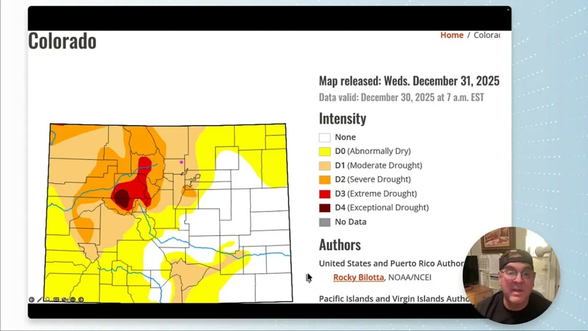
- Drought concerns deepen — snowpack is near historic minimums and statewide precipitation is about 88% of normal.
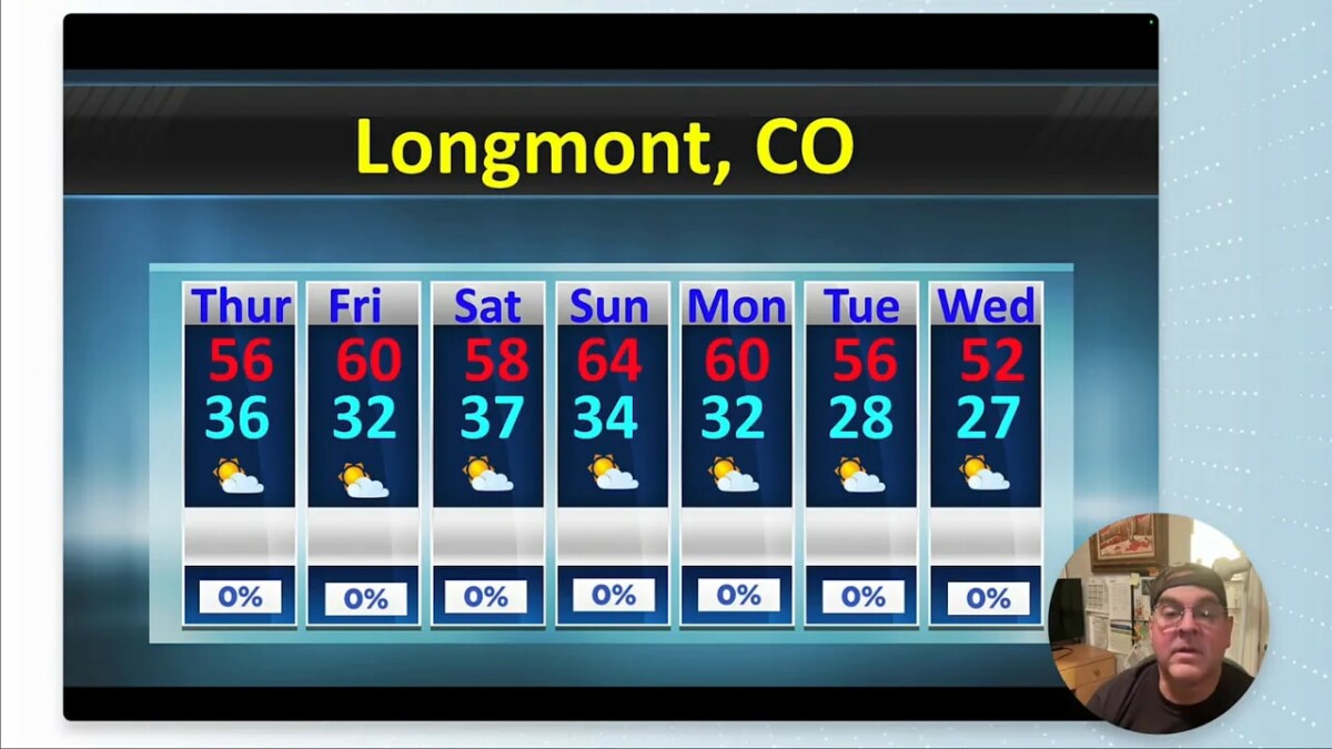
- Unusually warm with highs in the 50s and 60s for Longmont through midweek thanks to a strong ridge over the West.
- Precipitation mostly favors the mountains and western slopes; plains stay largely dry.
Moon, space weather and a chance of aurora
The moon is full Friday into Saturday and larger than usual in appearance. A sunspot cluster near the Sun’s equator produced a coronal mass ejection that is heading toward Earth. That means there is a reasonable chance to see aurora over the next day or two if geomagnetic activity ramps up.
Keep an eye on spaceweather.com or local space weather alerts for updates. A full moon will make faint aurora harder to see in areas with light pollution, but it is worth stepping outside if geomagnetic activity spikes.
Drought and snowpack: the story is worrisome
Snowpack across the region is in rough shape. As of January 1, reservoir- and mountain-based measurements show totals approaching the all-time observed minimum. Precipitation for the season is about 88% of normal, and much of what did fall came as rain rather than snow.
That rain-versus-snow split matters. Rain melts into immediate runoff or is less likely to recharge mountain snowpack that feeds rivers and reservoirs later in spring. Ski resorts and water managers are watching these numbers closely; reversing this trend will take consistent mountain snowfall.
Why it’s so warm: a persistent ridge
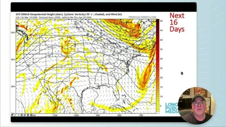
A broad ridge of high pressure is parked over the western U.S. and extending into the plains. That feature suppresses storms and keeps temperatures well above normal. Model imagery shows the ridge rebuilding repeatedly, which explains the prolonged warmth.
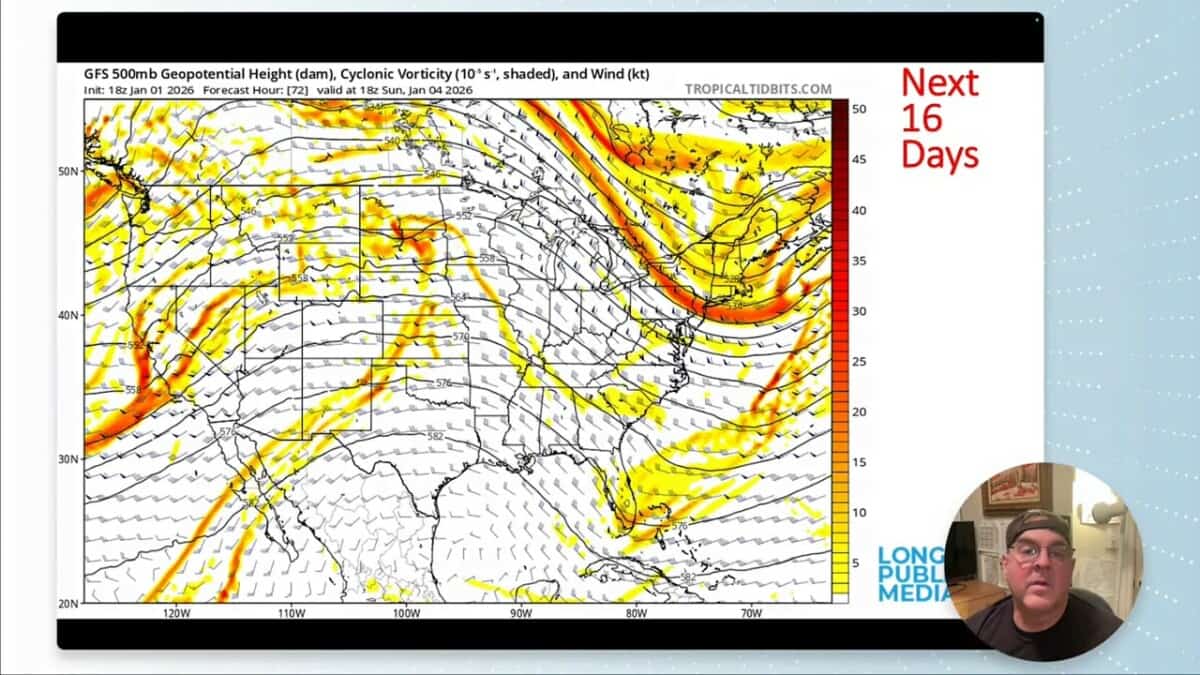
Temperature anomaly maps show many areas 6 to 16 degrees above normal, with localized spots nearly 20 degrees warmer than expected. For Longmont that translates into daytime highs comfortably above the seasonal average and mild nights compared to January norms.

Precipitation outlook: mountains get the most
Large-scale moisture is moving through the models, but there is little to lift it over the plains. That means precipitation will preferentially fall on the higher terrain where orographic lift helps squeeze moisture out of passing streams of air.
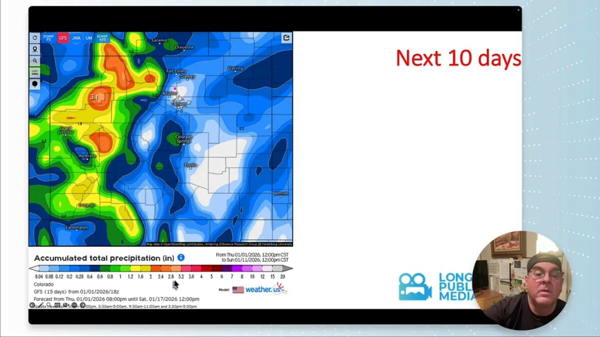
Expect western slope and mountain showers on and off this weekend and into early next week. Higher elevations could see a decent refill of snow, with some localized totals in the highest basins gaining several inches. The plains, including Longmont, remain on the dry side for the next 7 to 10 days.
Temperatures, winds and short-term hazards
Normal highs for early January are around the low 40s with lows in the mid to high teens. This week will be well above that. Longmont should see temperatures in the 50s and 60s through at least midweek. Winds pick up somewhat on Sunday, but otherwise conditions remain relatively calm.
On the bright side, mild conditions reduce the immediate risk of icy sidewalks. A personal note: after recent shoulder surgery, mild days are welcome — less worry about slipping on ice. For hydrology and winter recreation, however, these temperatures are not ideal.
Mountains vs plains: different winters nearby
Over the next five to ten days the mountains will collect the majority of precipitation. Model guidance shows 1 to 3 inches of water equivalent in many high-elevation basins, which helps snowpack and spring runoff prospects. Plains residents should not expect meaningful snow during this window.

Some localized mountain spots could show double-digit snow depths in short-term snapshots, while Longmont sits in a relative precipitation hole. Forecasts beyond 7 days carry greater uncertainty, and a shift in the pattern could change totals quickly.
Longer-range signals and wild-card possibilities
Most outlooks keep January warmer than average overall, but long-range models show potential for a pattern flip. One model suggested an extreme scenario — dozens of inches of snow for parts of northeast Colorado between now and mid-February. That outcome would require a sustained change to a stormy pattern, which is not the consensus at the moment.
Bottom line: a dramatic reversal is possible but not the most likely. Keep an eye on later-week model runs if you are planning around snow or water resources.
Actionable takeaways
- Look up Friday–Saturday if you want to try for aurora after the CME.
- Expect warm, mostly dry weather in Longmont for the coming week; pack lighter winter gear for daytime.
- Mountains should see the bulk of snow — travel and recreation plans for high country could improve, but check recent forecasts before heading out.
- Water managers and recreation industries should monitor snowpack closely; the current situation remains a drought concern.
Frequently asked questions
Will Longmont get measurable snow during the next week?
The forecast keeps Longmont largely dry for the next 7 to 10 days. Most precipitation is expected to fall in the mountains and on the western slopes. Plains snowfall is possible beyond the 7-day window, but confidence is low at this time.
Could the aurora be visible locally after the coronal mass ejection?
Yes. The coronal mass ejection increases the chance of aurora over the next day or two. Visibility depends on geomagnetic activity strength and local light pollution. A bright full moon will make faint displays harder to see.
How bad is the snowpack and what does that mean for water supply?
Snowpack is close to the observed minimum in some basins and statewide totals sit below normal. That reduces spring runoff and reservoir refill potential, which can stress water supplies if dry conditions persist through winter and spring.
Why are temperatures so much warmer than normal?
A strong ridge of high pressure over the West suppresses storm systems and allows milder air to persist. Repeated rebuilding of that ridge keeps temperatures several degrees above normal across the region.
Is severe weather a concern this week?
No significant severe weather threats are expected locally. Small pockets of convection could appear in isolated areas, and marginal risks exist for coastal California and the Central Valley for one of the incoming systems, but conditions are generally quiet for the plains.
Could the pattern flip and bring lots of snow?
A pattern flip is possible. Long-range models occasionally show a dramatic stormy phase that would deliver heavy snow, but current consensus favors a continued ridge with cooler, wetter spells mainly focused on higher elevations. Stay flexible and monitor forecasts closer to any potential event.
Final note
Warm days and dry conditions are welcome for convenience and safety, but the longer-term hydrologic impacts are a real concern. Keep an eye on mountain snow reports and space weather updates this weekend. And enjoy the full moon—if the geomagnetic conditions cooperate, the sky could put on an unexpected show.