Possible El Niño: Longmont Weather — February 19, 2026 to February 26, 2026
Week at a glance: a brief thaw, a Pacific system brushing the region with mountain snow, dry plains for a few days, and an encouraging long‑term shift toward El Niño that could help refill snowpack and ease drought concerns later in the year.
Table of Contents
- Quick highlights
- Where things stand now
- Short-term forecast: what to expect this week
- Precipitation and snowpack — mountains vs plains
- Temperature outlook
- Pattern change: El Niño on the horizon
- What this means for drought and water supply
- Practical takeaways
- Five‑ and ten‑day summary
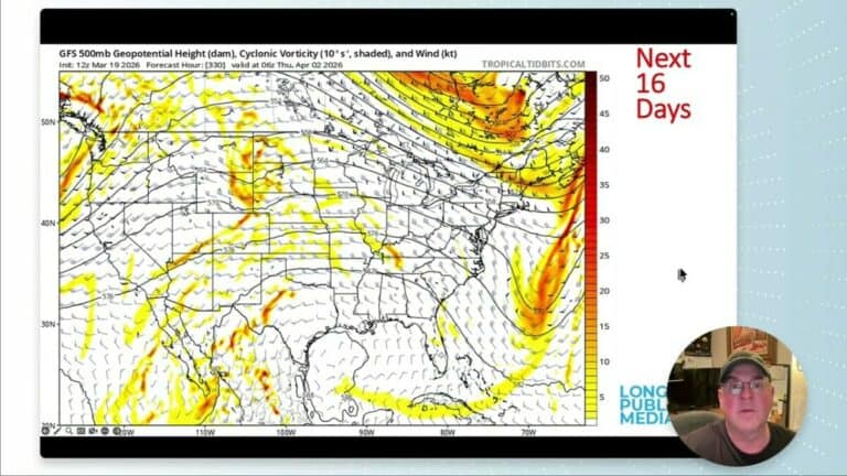
- Longer range
- Will the plains see significant snow this week?
- Final note
Quick highlights
- Evening sky: first quarter moon on Tuesday, February 24 — a pleasant evening to take a walk.
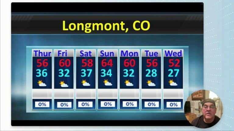
- Temperatures: steady warming trend; seasonal highs nudging from the upper 40s into the low 50s next week.
- Precipitation: mountains pick up most of the moisture; plains remain mostly dry though the next system brings light snow to higher terrain.
- Fire danger: warm and windy midweek next week will raise fire risk Wednesday through Friday.
- Big picture: models increasingly favor a transition from La Niña to El Niño — a potentially wetter pattern later in 2026.
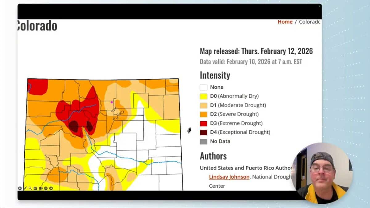
Where things stand now
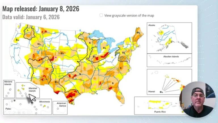
The state has slid back from the drought‑free conditions of mid‑2023. Some northeastern areas show extreme to exceptional drought, and the snow water content statewide recently dropped to historical minimums before a modest rebound.
Short-term forecast: what to expect this week
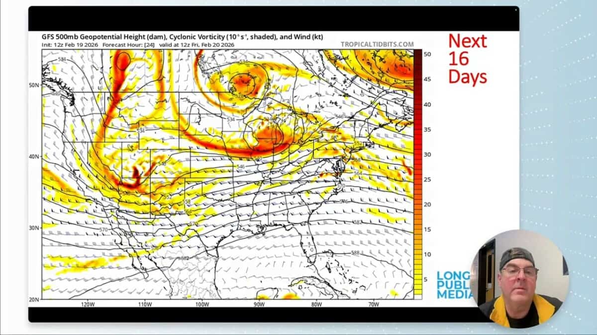
Thursday–Friday
A Pacific trough swings through, sending moisture across the mountains and a little into the plains. Expect:
- Mountain snow totals: meaningful accumulations, especially on western slopes and the highest peaks.
- Plains: mostly dry; any snow that falls will be light and spotty.
- Severe weather: notable convection is expected downstate and well to the east, with some risk in the Ohio Valley.
Saturday
Quiet and clearing behind a cold front to the north. Cooler, bright conditions over the weekend, though not unusually cold.
Next week
Fast swings in the pattern: a ridge returns briefly, leading to a warm, windy midweek and elevated fire danger. Then late in the week and into early March several troughs and cutoff lows could bring another round of cooler, wetter weather.
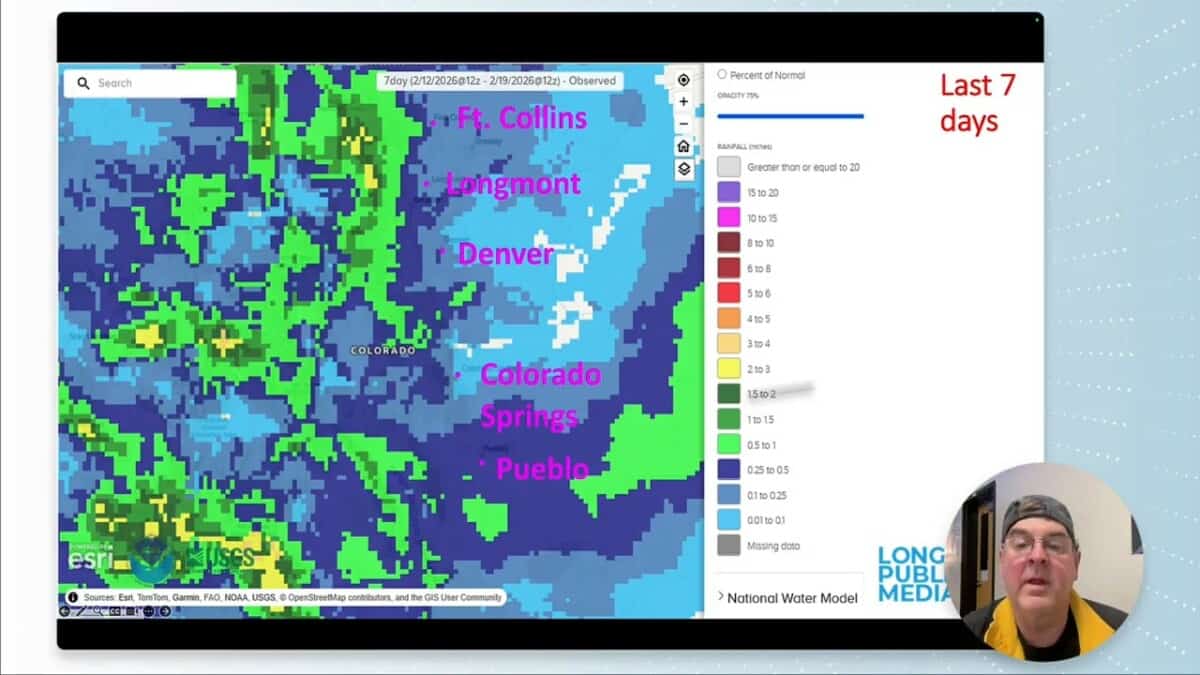
Precipitation and snowpack — mountains vs plains
The week’s moisture is primarily a mountain story. Models show:
- 5‑day mountain precipitation: up to about 1 inch liquid; with a typical 10:1 snow ratio that translates into roughly 10 inches of snow at higher elevations.
- 10‑day outlook: central and northern mountains could see 1.4 inches liquid — roughly 14 inches of snow in favorable locations.
- Plains: little accumulation expected; dry surface dew points will limit snowfall on the eastern plains through the upcoming Friday.
Temperature outlook
Normal highs are climbing from about 47 to 50°F, lows near the low 20s. Expect:
- Brief chilly days this weekend but mostly above freezing on the plains.
- A pronounced warm and windy spike midweek next week — temperatures could approach the high 60s to around 70°F in places.
- Cold shots arrive briefly at the end of February and early March, especially with troughs that dig farther west.
Pattern change: El Niño on the horizon
Forecasters and models are increasingly aligned on a transition from La Niña to El Niño later this year. The significance:
- La Niña had a drying influence across much of the country for the last 2–3 years. An El Niño can alter storm tracks and increase Pacific moisture supply.
- Model probabilities cluster around a ~60% chance of El Niño developing by mid‑to‑late 2026, with neutral and La Niña odds shrinking.
- For the region, El Niño often means near‑normal to enhanced precipitation and a shift in temperature patterns that can favor more consistent mountain snowfall through late winter and spring.

What this means for drought and water supply
A sustained El Niño would be welcome: it increases odds for a more continuous moisture supply into the mountains, helping snowpack and spring melt. That said, the timing and strength matter — a single season won’t erase multi‑year deficits, but it can make a meaningful contribution.
Practical takeaways
- If you live on the plains: expect dry conditions through the immediate weekend; plan for a warm, windy stretch midweek that increases fire danger.
- If you recreate in the mountains: anticipate several good windows of snowfall over the next 10 days, with western slopes and high peaks seeing the biggest totals.
- Outdoor plans: Tuesday evening (February 24) features a pleasant first quarter moon — a nice, mild night for a walk.

Five‑ and ten‑day summary
- 5‑day: Dry on the plains; mountains pick up to ~1 inch liquid (roughly 10 inches of snow at elevation).
- 10‑day: Central and northern mountains may see ~1.4 inches liquid (about 14 inches of snow in spots); models then trend warmer and show snow melting back in the lowlands.
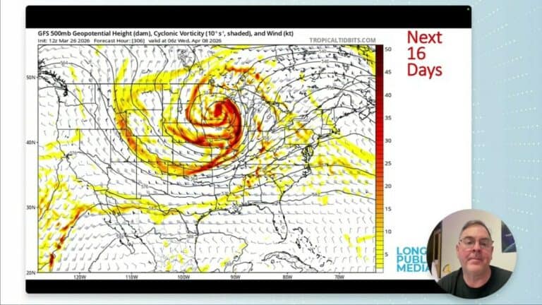
Longer range
The two‑week view is generally warmer and near average for precipitation. The bigger story is the likely El Niño later in 2026, which could mean a shift toward more consistent moisture and a better chance to rebuild snowpack and ease drought conditions.
Will the plains see significant snow this week?
Not likely. The next systems focus moisture on the mountains. Plains may see a light dusting or flurries in spots, but substantial accumulation is unlikely through Friday.
How much snow can the mountains expect?
Models suggest roughly 1.0 to 1.4 inches of liquid over the next 7–10 days for central and northern mountains. With typical ratios that converts to about 10–14 inches of snow in favored areas.
Is the drought improving?
There was a short recovery in 2023, but drought has returned in parts of the state. A stronger El Niño would improve the odds for wetter months, but recovery depends on sustained snowpack and spring melt.
When will fire danger be high?
Expect increased fire danger next week during the warm, windy midweek period — Wednesday through Friday — when gusts and low humidity combine to raise risk.
Final note
Weather will keep oscillating between quick warmups and pulsed storms. The encouraging long‑term signal toward El Niño offers a reason for cautious optimism about snowpack and moisture later in the year. Keep an eye on mountain forecasts if you plan winter recreation, and be mindful of the elevated fire risk during windy, warm stretches.
Keep looking up.