Longmont Weather Report: April 30, 2026 to May 6, 2026

Here comes May, and with it comes one of those classic Colorado forecast stretches where just about everything is on the table. We are gaining daylight fast, the drought picture is still concerning, the snowpack is running low, and yet the atmosphere is starting to show some signs that it may finally want to work with us for a few days next week.
The short version is this: dry and warmer through the weekend, then cooler and more unsettled Monday through Wednesday with a real shot at rain and possibly the first stronger thunderstorms of the season. Whether the atmosphere actually cashes that check is another matter, but the ingredients are at least trying to come together.
Table of Contents
- Seasonal markers: more daylight, a third quarter moon, and early May energy
- Drought is still the big story
- Snowpack and water supply: a little uptick, but still far behind
- Severe weather season is arriving
- What is normal for this time of year in Longmont?
- The large-scale pattern: ridge for the weekend, low pressure next week
- Temperature swings: warm weekend, brief cooldown, then warmth returns
- Moisture finally improves next week
- Rain chances: the best window is Monday through Wednesday
- Why the rain forecasts may be overdone
- Snowfall projections are shaky too
- The practical day-by-day setup for Longmont
- What the May outlook suggests
- Bottom line
- FAQ
See last week’s weather report: Longmont Weather Report: April 23, 2026 to April 30, 2026
Seasonal markers: more daylight, a third quarter moon, and early May energy
Friday, May 1 starts with a third quarter moon in the morning sky. Solar activity is fairly active, but nothing especially complex, and nothing has recently produced the kind of event that would lead to aurora excitement.
Meanwhile, the change most people will actually notice is the daylight. Sunrise is at 6:12 a.m. and sunset is at 7:27 p.m. That is close to another half hour of daylight gained over the course of the week, and it is becoming noticeable in everyday life. Mornings are no longer pitch dark during the early routine. The sky is already starting to glow.
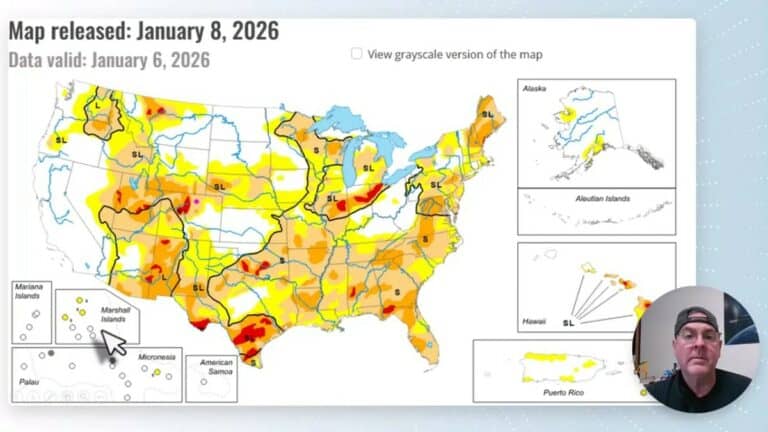
Drought is still the big story
The drought situation around Longmont has worsened a bit. Some of the area that had been classified as abnormally dry has slipped into moderate drought. There has been a little relief in the far northwest, but broadly speaking the national pattern has not changed much, aside from some worsening in the Southeast and a few expanding dry pockets in the Intermountain West.
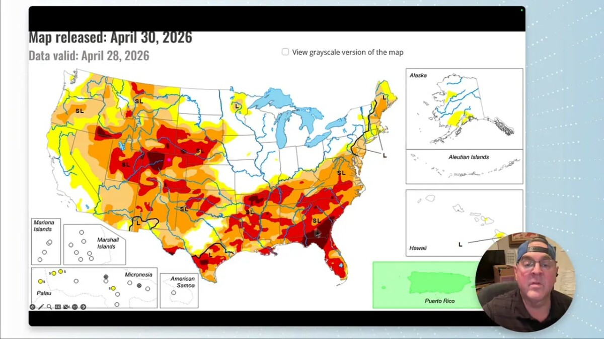
For Colorado, the signal for May is not especially comforting. Much of the rest of the state is expected to see drought development. That makes the next several weather systems more important than they might otherwise seem. Any meaningful moisture helps, especially this time of year when the landscape is trying to green up.
One genuinely positive note: smoke and fire activity are minimal to nonexistent right now. With drought concerns increasing, that is very good news.
Snowpack and water supply: a little uptick, but still far behind
The bad news with water continues to be the snowpack. As of April 30, the local snow water content was down to about 19%, though it had ticked up a little after some fresh snow coated the higher peaks. More late-season mountain snow is possible again this week, so there may be another small bump.
That said, this is still a very late-season situation. Even if the numbers improve modestly, the region remains deep in the red compared with where it should normally be.
Total water supply has also improved slightly, reaching about 75% of median. So the water is coming in some form, just not through the slow-release snowpack runoff that tends to be most helpful. That slow melt acts like a natural reservoir. Rain can help, but it does not replace a healthy snowpack.
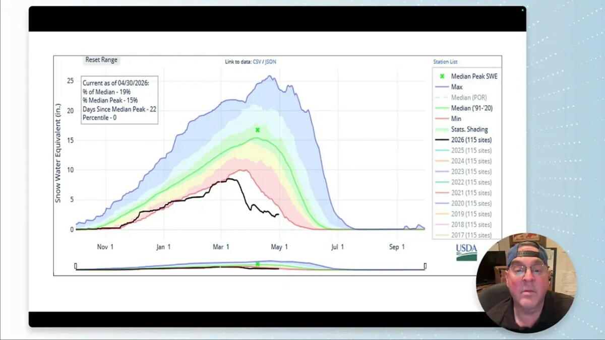
There was at least some precipitation over the past week, with many areas picking up something. The issue is consistency and scale. Small hits here and there are not the same thing as a sustained wet pattern.
Severe weather season is arriving
Climatologically, early May is when the severe weather signal begins climbing into Colorado. The first meaningful tier of increased probability has now pushed into the state, and that means it is time to start paying closer attention to thunderstorms.
The first stronger thunderstorms of the season may develop early next week. That does not automatically mean widespread severe weather in Longmont, but it does mean the environment is moving in that direction.
For the near term, general thunderstorm chances stay mostly to the southwest, into the mountains and Four Corners region. The pattern favors:
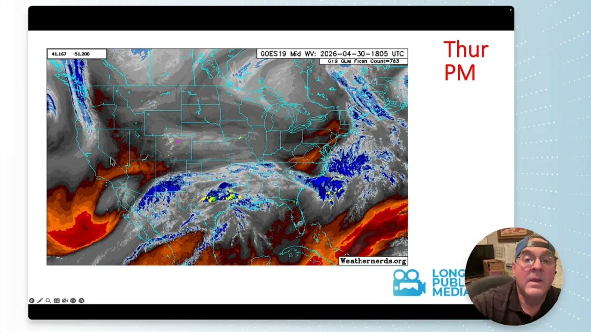
Thursday: a slight chance of showers and some mountain snow, including a few higher-elevation spots with heavier snow
Friday into Sunday: thunderstorm activity focused more toward the Four Corners and areas to the west and southwest
Monday through Wednesday: a better setup for northeastern Colorado, including Longmont, as moisture and instability increase
What is normal for this time of year in Longmont?
By the start of May, average high temperatures are around 58 to 60 degrees, and average lows have climbed to around 30 to 32 degrees.
Longmont’s early-May temperature extremes are a reminder of how wild spring can be here:
Record high: 84 degrees, reached on both May 1 and May 2 in adjacent years, 2011 and 2012
Record low: minus 2 degrees on May 2, set in 1975, which also stands as the monthly record low
That spread tells the whole Colorado spring story. Summer warmth can show up early, but winter still knows the address.
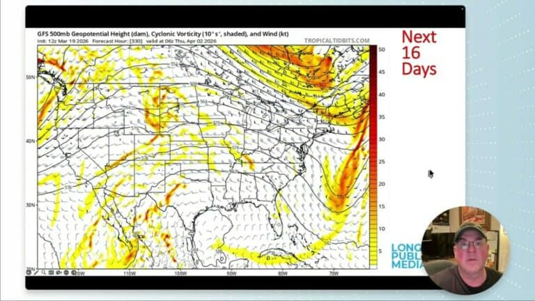
The large-scale pattern: ridge for the weekend, low pressure next week
The bigger atmospheric setup explains most of the forecast. A ridge is building over the western United States for the weekend, and that should give the Front Range a dry, warm, and generally pleasant stretch.
Then things begin to change. A low pressure system from the southern branch of the jet stream starts reconnecting and moving across the region through Wednesday. That opens the door for two things Longmont needs right now:
Instability, which helps thunderstorms develop
Moisture, which gives those storms something to work with
After that, the ridge tries to return later in the week and into next weekend, but it does not look especially strong. Another trough follows, and then the pattern shifts into northwest flow. In Colorado, northwest flow can be quiet if the air is dry, but if there is moisture around, even a small ripple in that flow can kick off thunderstorms.
Looking farther out toward the middle of the month, another stronger trough appears possible around the 13th or 14th. The details are highly uncertain at that range, but the pattern does not look locked into endless dryness just yet.
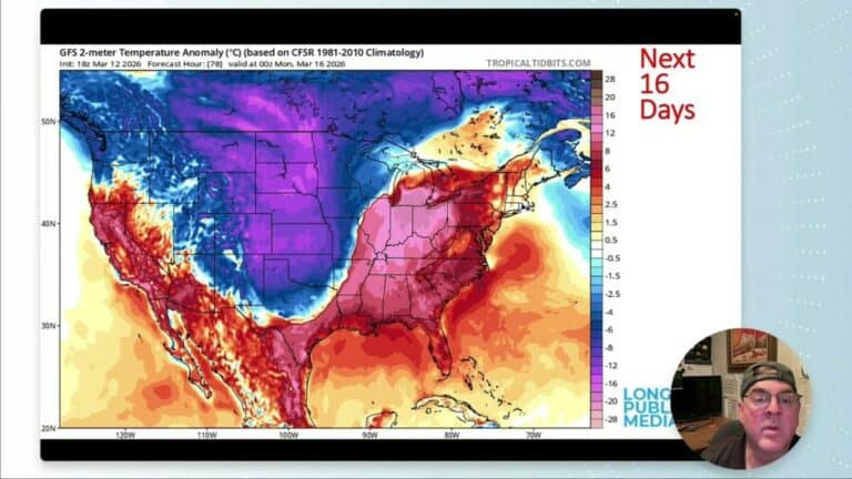
Temperature swings: warm weekend, brief cooldown, then warmth returns
This is one of those back-and-forth setups common east of the Rockies. Warm ridging builds in, then cooler air tries to push south along the plains side of the mountains.
Here is the broad temperature story:
Thursday: chilly, with a chance of showers
Friday through the weekend: warming quickly, with some plains locations possibly reaching the 80s
Monday through Wednesday: cooler as moisture and cloud cover increase
Late next week: warmth builds back in
Beyond that: another cool push may arrive the following Monday, almost like a one-week repeat of the same pattern
One interesting feature in the forecast is that some of the cool air tries to arrive from the southwest first, then gets reinforced by a stronger push from Canada. As usual, the mountains shape how that air can spread, keeping the east side of the Rockies in its own complicated spring battleground.
Moisture finally improves next week
Through the weekend, the atmosphere remains very dry. That means plenty of sunshine, quick warmups, and not much support for meaningful precipitation.
Then, starting Monday, moisture begins moving in from the southwest and rapidly deepens through Wednesday. That is visible both in the broader atmospheric moisture fields and at the surface.
Surface dew points climb into the upper 30s and around 40 degrees by Tuesday and Wednesday, which is exactly the kind of low-level moisture that can support beneficial rain in this area.
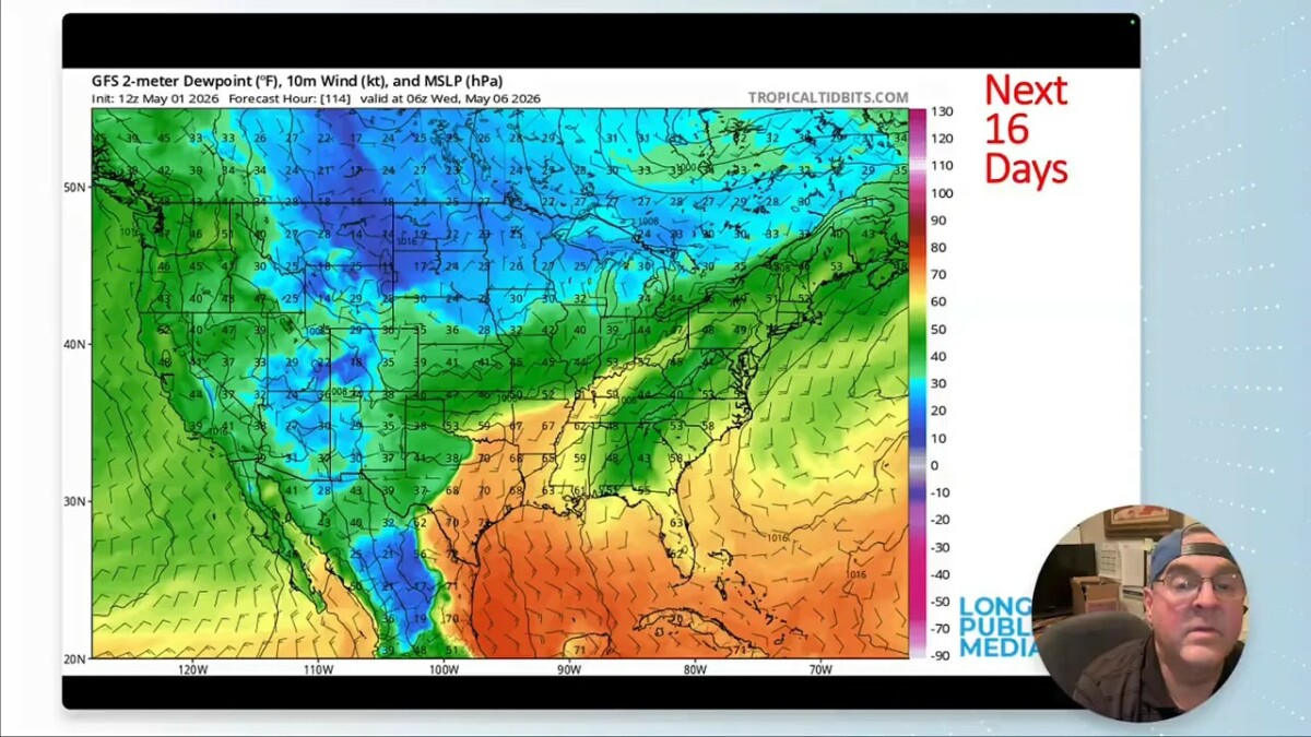
Even more encouraging, the moisture does not appear to get completely scoured out afterward. Deep moisture remains pooled over the Great Plains and tries to wrap back westward around low pressure, potentially sending another shot of humidity toward Colorado around the 10th.
In other words, the atmosphere is at least trying to set the table.
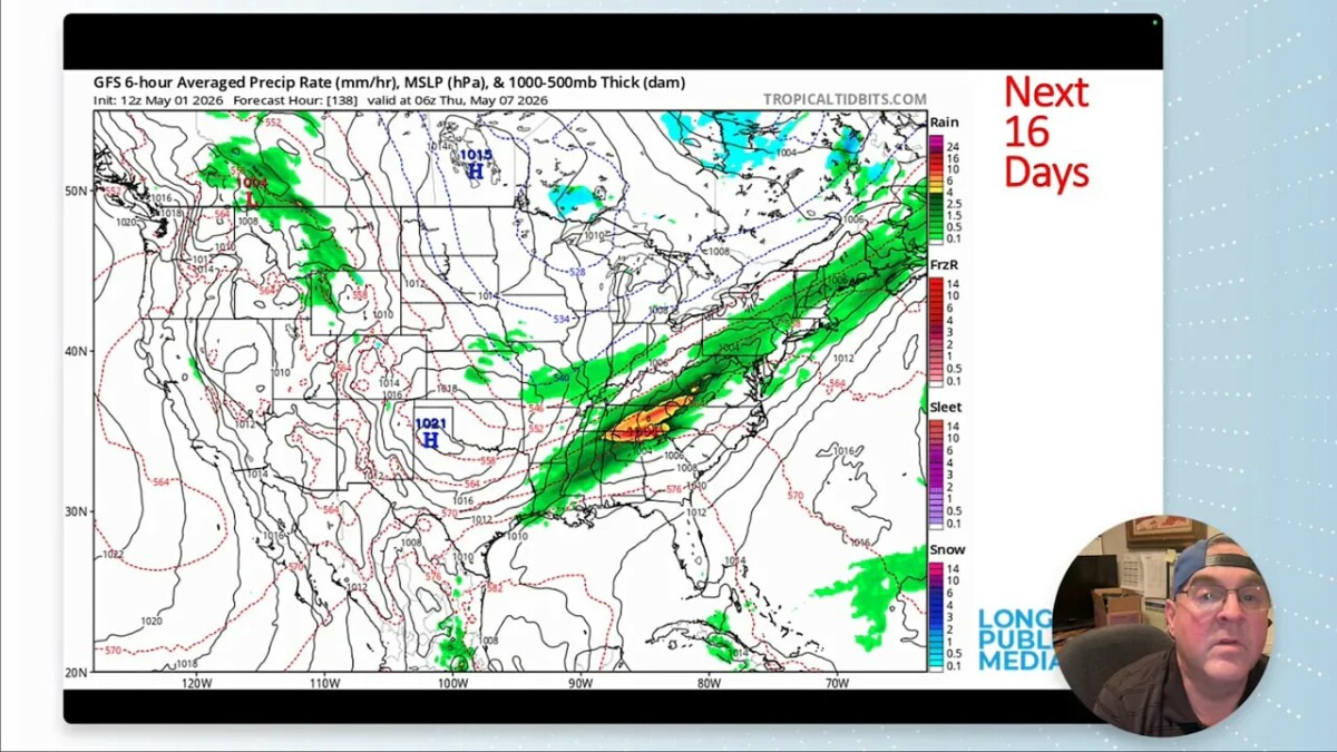
Rain chances: the best window is Monday through Wednesday
Saturday and Sunday look very dry across the West, while a large storm on the East Coast pulls away. Then on Monday, a low begins to form to the southeast of Colorado, and that allows a band of precipitation to push back into northeastern Colorado.
That is an important detail. When low pressure forms in the right place, it can pull moisture back westward into the Front Range and plains, rather than sweeping it away.
The precipitation setup next week includes:
Monday: showers and thunderstorms begin increasing
Tuesday: likely the wettest day of the stretch
Wednesday: lingering rain chances, with some snow mixing in over higher foothill elevations
After that, conditions dry out again for a bit late in the week. Next weekend could bring scattered showers, and then another broader shield of rain may try to arrive at the start of the following week.
Farther out, around the middle of the month, one modeled low looks more favorable for Wyoming and Nebraska than for Longmont, but at two weeks out there is plenty of room for that to change.
Why the rain forecasts may be overdone
There is a healthy dose of skepticism in this forecast, and for good reason. Some of the model output, especially from the GFS, is likely too aggressive with precipitation totals.
At various points the model suggests:
Up to 3 inches of rain over 10 days in parts of the region
Around 1 inch near Longmont
Heavy mountain snowfall totals that do not look especially realistic for this setup
That is probably too much. The reason is not just model bias. It is also the land itself.
When drought deepens, the landscape becomes a weaker moisture source. Dry soils and stressed vegetation reduce evapotranspiration, which is the process by which moisture moves from the ground and plants back into the lower atmosphere. From Colorado southward into Texas, if the land is dry, the low levels of the atmosphere miss out on some of that normal moisture contribution.
So even if a weather pattern looks promising on paper, it can underperform when the region feeding the air mass is parched.
That helps explain why recent forecasts showing big blobs of rain have fizzled. One recent setup had suggested nearly an inch of rain over a couple of days, and instead many places got little more than a sprinkle near I-25.
The important threshold to watch is whether storms can begin occurring often enough to green up vegetation and moisten the soil. Once that happens, the land can start helping the atmosphere again, and bigger rainfall forecasts become more believable.
Snowfall projections are shaky too
The same caution applies to snowfall numbers. Some forecast products are throwing out eye-catching totals such as 20 inches in five days or more than 23 inches over 10 days in the mountains. Those numbers do not appear especially trustworthy right now.
A more realistic experimental guidance set shows a simpler story:
a bit of fresh snow at higher elevations in the short term
some lingering snow depth several days out
then melting reducing that snowpack again by the 10-day mark
That fits the season much better. It is late enough now that even fresh mountain snow often comes with a short shelf life.
The practical day-by-day setup for Longmont
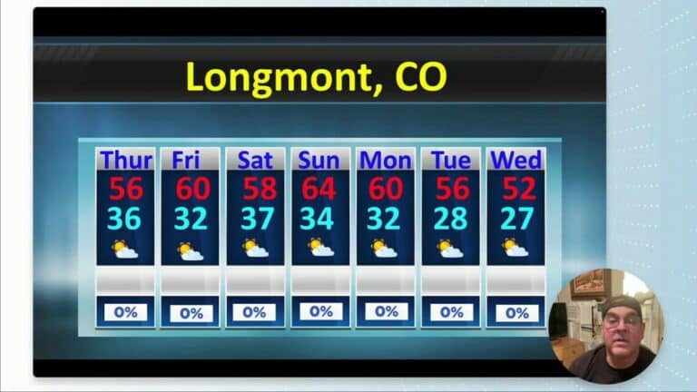
Thursday
Chilly with a chance of showers. Higher elevations can pick up some snow, with a few spots seeing heavier bursts.
Friday through Sunday
Warmer and drier. This looks like the nicest stretch of the forecast, with plenty of sunshine and a spring-to-early-summer feel. Some plains areas may flirt with the 80s.
Monday
Moisture starts increasing. Showers and thunderstorms become more likely, and this may be the beginning of the first stronger thunderstorm setup of the season.
Tuesday
The wettest day of the period. If the forecast verifies, this is the day most likely to bring meaningful rain to Longmont.
Wednesday
Still unsettled, with lingering precipitation chances. Cooler air may allow a rain-snow mix in some higher foothill areas by the end of the event.
What the May outlook suggests
Looking out through the broader month of May, the outlook leans warmer than normal. The precipitation outlook is less decisive, with equal chances overall, but the drought-oriented signal still points toward a month that could end up drier than normal if these rain opportunities underperform.
That leaves us in a familiar Colorado spring spot: enough action to keep hope alive, but not enough confidence to declare a pattern change.
Bottom line
Longmont heads into early May with a mixed bag.
Daylight is increasing quickly and the weekend looks warm and pleasant.
Drought remains a concern, and snowpack is still well below normal.
Moisture improves Monday through Wednesday, bringing the best chance for useful rain.
Tuesday currently looks like the wettest day.
The first stronger thunderstorms of the season are possible, especially early next week.
Model rainfall totals should be treated cautiously until the landscape and atmosphere start working together more consistently.
So yes, there is finally some hope for water next week. The atmosphere seems willing. Now we find out whether it can actually deliver.
FAQ
Will Longmont get rain next week?
There is a solid chance of rain from Monday through Wednesday, with Tuesday looking like the wettest day. The setup is favorable for moisture and instability, but recent systems have underperformed, so confidence in exact rainfall amounts remains limited.
Could there be strong thunderstorms in Longmont?
Yes. Early next week may bring the first stronger thunderstorms of the season to northeastern Colorado. That does not guarantee severe weather in Longmont, but the seasonal pattern is shifting in that direction.
How bad is the drought around Longmont right now?
The drought has worsened slightly, with some areas moving from abnormally dry into moderate drought. Colorado also faces the risk of additional drought development during May if precipitation does not improve.
How is the snowpack looking?
Snowpack is still running very low for this point in the season. There was a small recent uptick from fresh mountain snow, but overall water content remains far below normal and total water supply is only around 75% of median.
Will the weekend be warm in Longmont?
Yes. Friday through Sunday should be dry and warmer, with some plains areas potentially reaching the 80s under a ridge of high pressure.
Why are rain forecasts so uncertain during drought?
Dry soils and stressed vegetation reduce evapotranspiration, which means less moisture gets added back into the lower atmosphere. That can make promising storm setups produce less rain than models suggest.