How Longmont Became America’s Only United Nations Resilience Hub
In May 2025, Longmont became the first city in the United States to be named a United Nations Resilience Hub, joining a global network of communities recognized for their advanced approach to disaster preparedness and recovery. That designation did not come from a grant application or a political campaign. The UN recognized Longmont for more than a decade of deliberate, measurable work that began in the wreckage of one of Colorado’s worst natural disasters. The September 2013 floods devastated the community, but Longmont focused on creating infrastructure rebuilt to withstand future events and community programs for resilience.
What Is a UN Resilience Hub?
The MCR2030 Program and Stage C Recognition
A UN Resilience Hub is a formal designation from the United Nations Office for Disaster Risk Reduction (UNDRR) through its Making Cities Resilient 2030 (MCR2030) program – an international initiative focused on helping cities reduce disaster risk and build long-term resilience.
Hubs are local authorities committed to supporting and mentoring other MCR2030 municipalities, and the role is largely outward-facing: providing knowledge-sharing, capacity-building, and learning opportunities for other local governments, coordinating study tours, twinning with cities earlier in the process, and publishing case studies from their own experience. The designation is reviewed every three years and must be earned, not simply applied for.
Longmont received Stage C recognition, the highest level available in the program. According to UNDRR, cities at this stage “have a relatively robust DRR, resilience and sustainability plan in place” and “must demonstrate commitment to implement and mainstream DRR and resilience across all sectors.” DRR stands for disaster risk reduction.
Longmont now joins Dubai, Venice, Mexico City, and Incheon, South Korea as recognized Resilience Hubs in the MCR2030 global network.
How the September 2013 Floods Exposed Longmont’s Disaster Preparedness
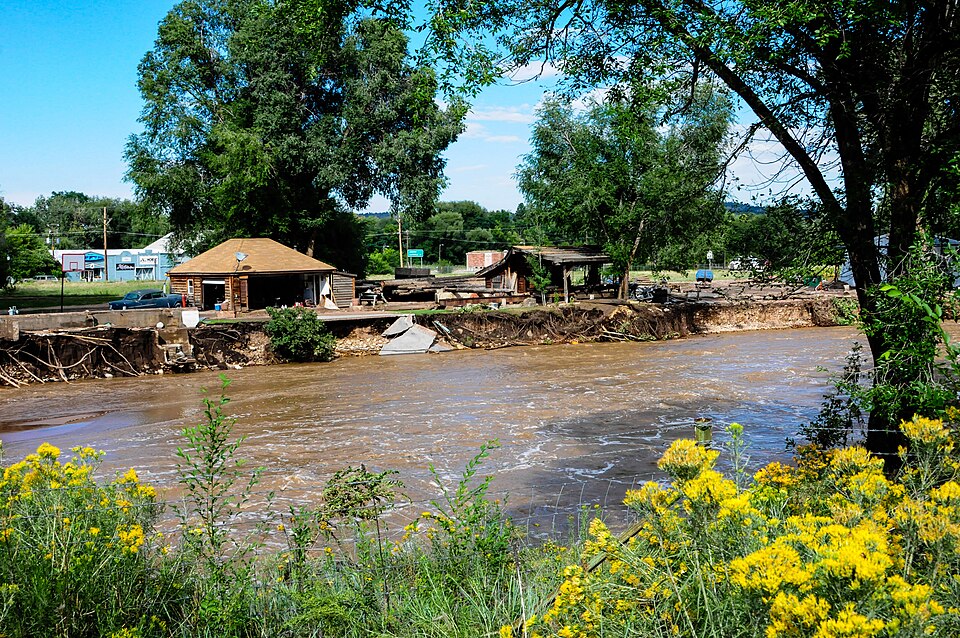
From September 9 through 16, 2013, catastrophic floods swept across the Colorado Front Range, forcing thousands of residents from their homes and leaving entire neighborhoods underwater. In Longmont, the St. Vrain River burst its banks with devastating force, causing nearly $150 million in infrastructure damage to the city alone. Roads were destroyed, utilities were severed, and the creek — narrowed over generations of farming and development until it functioned more like an irrigation ditch than a natural stream — proved wholly unprepared for several days of heavy rains. The scale of destruction made one thing unmistakably clear: rebuilding to pre-disaster conditions would not be enough.
A Turning Point, Not Just a Tragedy
Instead of banking on projections that characterized the floods as a 500 year or 1000 year event, Longmont decided to rebuild for the possibility of another flood. City leaders recognized early that simply restoring what existed before was a way to guarantee the same disaster would happen again.
Instead, they made a deliberate decision to treat recovery as an opportunity to build infrastructure, systems, and community capacity that could withstand future events rather than simply survive the current one. That intentional, forward-looking approach became the foundation for everything that followed.
Rebuilding the River — The Resilient St. Vrain Project
The Resilient St. Vrain Project is Longmont’s master plan for comprehensive channel improvements along the St. Vrain Creek. Before the 2013 floods, the creek had been progressively narrowed over generations — pushed in by farming, development, and community growth until it resembled an irrigation ditch more than a functioning natural waterway. That constriction made catastrophic flooding not just possible but inevitable under the right conditions.
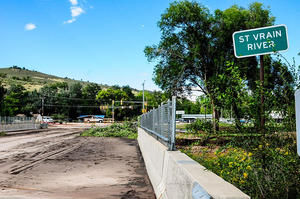
Following 2013, the city undertook a fundamental redesign — widening and reshaping the channel to safely contain and pass large storm events without flows escaping the banks. The redesigned channel leans on natural features rather than hard engineering alone, an approach that earned international attention for both its environmental soundness and its long-term financial viability. The end goal was a creek corridor built to absorb what future storms deliver.
The Infrastructure Work You Can’t See
Not all of Longmont’s resilience work is visible from the riverbank — and some of the most important changes are entirely hidden from view. Before 2013, several water lines were suspended beneath bridge crossings over the creek, leaving them dangerously exposed during flood events. Following the disaster, the city buried all of those utilities deeply beneath the channel bed, protecting them from damage even in major future storms. The combination of visible channel redesign and invisible utility hardening reflects how comprehensively Longmont approached the rebuild.
The Be Ready Longmont Program
Longmont’s recovery leadership also emphasized early that physical infrastructure, however well designed, is only part of the resilience equation. The Be Ready Longmont program extends resilience planning directly to residents and businesses through disaster preparedness education. The program’s emphasis goes beyond emergency kits and evacuation routes — it actively encourages neighbors to know each other, to build the kind of social trust that makes a community function under pressure. The underlying philosophy is straightforward: a connected community responds more effectively to disaster than an isolated one, regardless of how well-engineered its flood channels are.
Communication Systems and Language Access
Effective emergency response depends on information reaching everyone. Longmont has upgraded its emergency communication systems beyond traditional sirens, adopting reverse 911 calls to reach residents directly. Critically, all emergency communications are provided in both Spanish and English — ensuring that a language barrier never becomes a public safety barrier.
Wildfire and Climate Adaptation
Longmont’s resilience planning has grown to incorporate wildfire planning and climate change adaptation into its broader strategy, applying what it calls a “whole community” resilience lens to public safety, local business continuity, and the broader local economy.

How Longmont’s Recognition Makes it a Model for Mid-size Cities
Perhaps the most relevant aspect of this recognition is what it signals to communities that don’t see themselves in the same conversation as Dubai or Venice. Longmont’s approach — combining channel engineering, community education, utility hardening, and coordination across federal, state, and local government — is built from replicable decisions, not exceptional circumstances. The designation provides a roadmap for cities without outsized budgets to recover from weather disasters and actively prepare for future events.
Longmont’s Responsibilities as a Resilience Hub
Recognition as a Resilience Hub comes with defined obligations. Longmont will now support other communities working to develop and strengthen their own disaster planning and recovery programs — sharing documented strategies while continuing to engage with the broader MCR2030 global network.
FAQs
What is a UN Resilience Hub?
A Resilience Hub is a city formally recognized by the United Nations Office for Disaster Risk Reduction (UNDRR) through its Making Cities Resilient 2030 (MCR2030) program. The designation goes to local governments that have demonstrated an advanced, documented track record in disaster risk reduction, and are committed to helping other cities develop their own resilience strategies. It is both a recognition of past work and an ongoing obligation.
Why did Longmont receive the UN Resilience Hub designation?
Longmont was awarded this UN designation because of the Resilient St. Vrain Project and the city’s comprehensive, multi-layered response to the September 2013 floods — an approach that combined channel engineering, utility hardening, community education, and coordination across federal, state, and local government. The MCR2030 program evaluates cities on demonstrated action and measurable outcomes, not planning documents alone.
What is the Resilient St. Vrain Project?
The Resilient St. Vrain Project is Longmont’s master plan for redesigning the St. Vrain River channel to safely contain and pass large flood events without threatening surrounding neighborhoods. The project addressed not only the creek itself but the infrastructure, utilities, and community systems that the 2013 floods exposed as vulnerable.
What is the St. Vrain River?
The St. Vrain River is a Front Range waterway that flows through Longmont on its way from the Rocky Mountain foothills to its confluence with the South Platte River. It is the primary drainage corridor for the city and the central feature of Longmont’s flood resilience work.
How bad were the September 2013 floods in Longmont?
The St. Vrain River burst its banks during a multi-day statewide rain event, causing nearly $150 million in infrastructure damage and forcing thousands of Front Range residents from their homes. The flooding was part of a broader Colorado disaster that affected communities from Boulder County to the South Platte corridor — one of the most destructive flood events in state history.
Is Longmont the only UN Resilience Hub in the United States?
Yes. Longmont is currently the first and only U.S. city to receive this designation through the MCR2030 program.
What other cities are UN Resilience Hubs?
The global network includes Dubai (UAE), Venice (Italy), Mexico City (Mexico), and Incheon, South Korea — all cities that have met MCR2030’s Stage C criteria and committed to supporting other communities through the peer-learning network.
What does the Resilience Hub designation require going forward?
Hub cities are expected to actively support other communities working toward disaster resilience — sharing strategies, hosting knowledge exchanges, and reporting their activities annually through the MCR2030 dashboard. The designation is reviewed every three years.