
Longmont Weather Report: July 11, 2026 to July 18, 2026
Longmont is headed into a serious midsummer heat stretch. Expect bright sun, highs in the 90s with a run near 100 degrees, very little rain, and elevated fire weather concerns as dry air and wind combine Sunday and Monday.
The good news is that the monsoonal pattern is still out there. It is mostly wrapping around Colorado for now, feeding storms in Arizona, New Mexico, Utah, and western Colorado. Moisture should finally begin working back toward the Front Range around July 22 or 23, opening the door for a more regular afternoon thunderstorm pattern.
Table of Contents
- The quick Longmont forecast
- A heat dome parks over Colorado
- Dryness and fire weather remain the local concern
- Where the thunderstorms will be
- The monsoon return is the light at the end of the hot spell
- What the longer range outlook suggests
- Sky notes for the week
- FAQ
The quick Longmont forecast
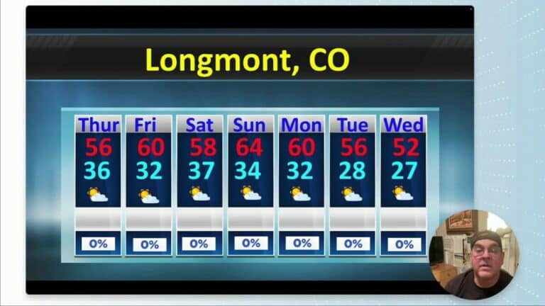
For Saturday, July 11 through Friday, July 17, the pattern is overwhelmingly hot and dry. Daily high temperatures are expected to stay in the 90s, with the hottest readings near 100 degrees early in the period. Overnight lows should generally hold in the upper 50s to mid 60s.
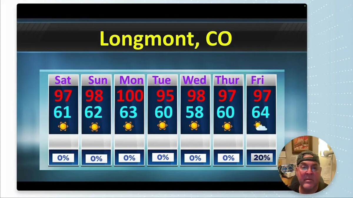
- Saturday: Around 97 degrees, with a low near 61.
- Sunday: Around 98 degrees, with a low near 62. Expect some wind.
- Monday: Near 100 degrees, with a low around 63.
- Tuesday: Near 96 degrees, low around 60.
- Wednesday: Near 94 degrees, low around 58.
- Thursday: Near 87 degrees, low around 60.
- Friday: Near 93 degrees, low around 64, with only a small chance that moisture begins to sneak back in.
Most days carry essentially no rain chance. Friday has the best shot of the week for a little moisture, but it does not look like much.
A heat dome parks over Colorado
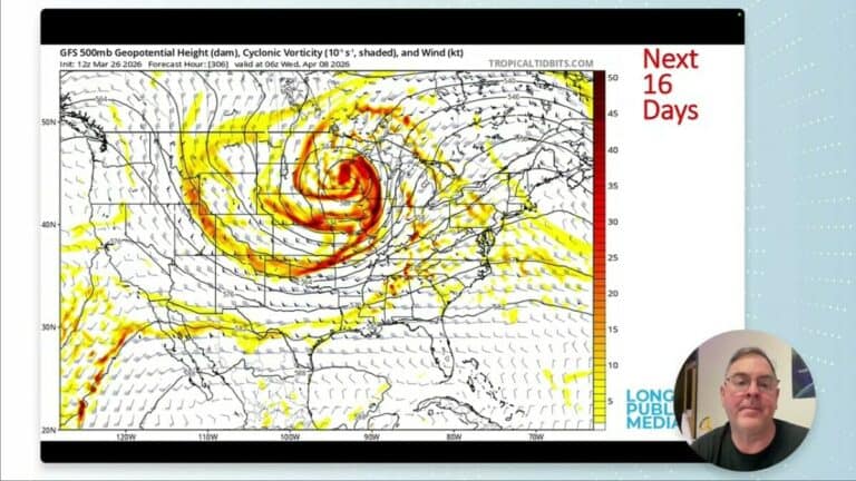
The main player is a large upper level ridge, the familiar summertime heat dome. Its center wobbles around Colorado through July 13 and 14, then remains dominant across much of the West and central United States.
That ridge means sinking air over Longmont. Sinking air warms and dries as it descends, which makes it hard for clouds and thunderstorms to develop even when surface dew points do not look terribly low. We are right in the dry middle of the circulation while moisture gets carried around its outer edge.
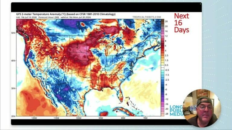
Temperatures are projected to run roughly 6 to 10 degrees above normal at the start of the period. The climate guidance has reached the seasonal peak for normal high temperatures, around 90 degrees, and normal overnight lows near 59 to 60 degrees. Actual temperatures, however, are pushing well beyond those values.
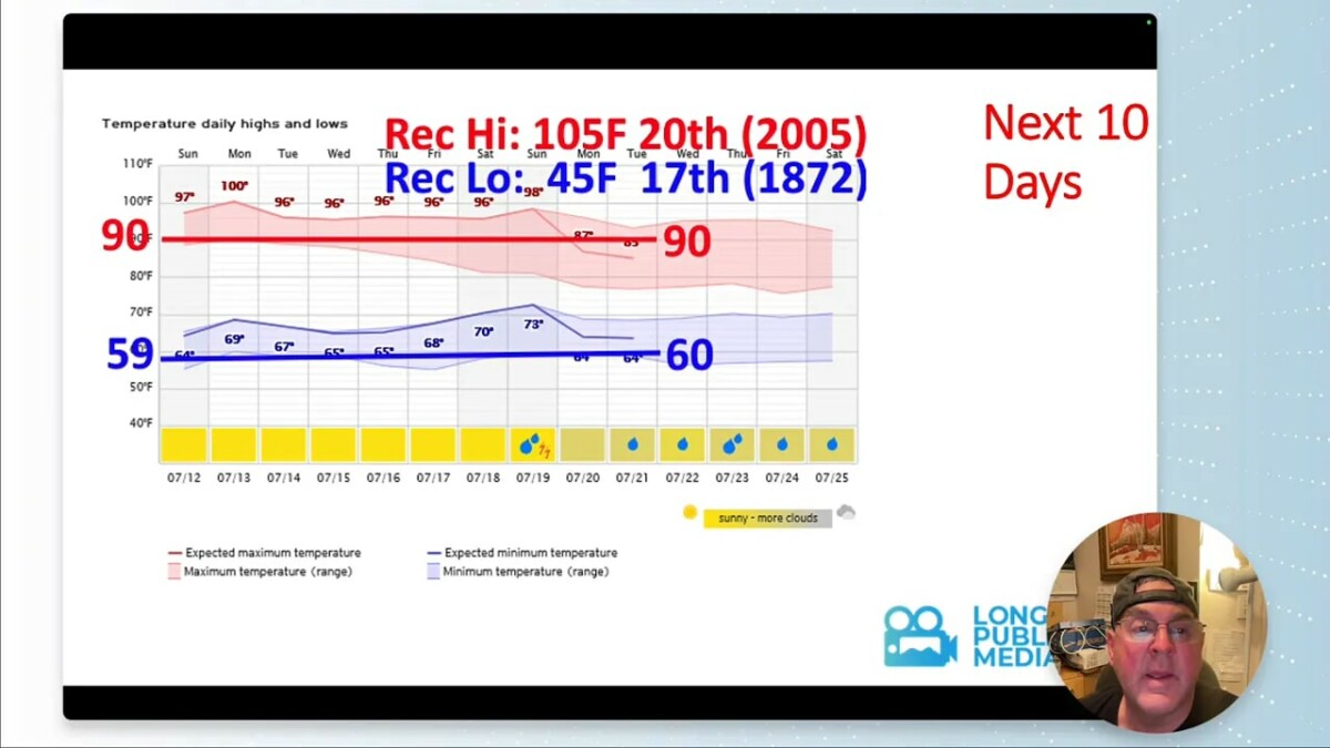
For perspective, Denver’s all time July record high is 105 degrees, set on July 20, 2005. The record low for this portion of July is 45 degrees, recorded July 17, 1872. We are not forecasting record heat, but this is still an impressively hot stretch.
Dryness and fire weather remain the local concern
Longmont remains in D2 severe drought. Conditions have worsened a bit across a broad diagonal zone from the Four Corners northeastward, while extreme and exceptional drought persist in other areas beyond the D2 category.
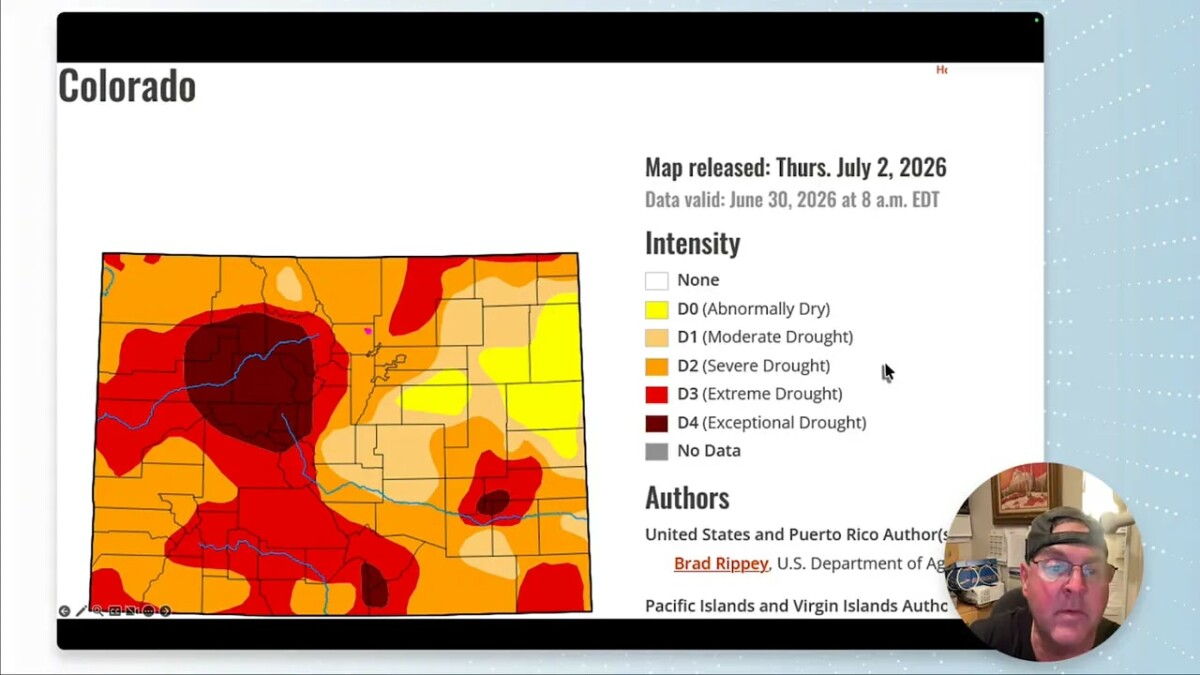
Colorado’s precipitation is running at about 73 percent of the median. There has been rain east of the Rockies recently, but that pattern is changing. During this stretch, the western slopes and areas west of the Rockies have better odds for precipitation while the plains remain largely dry.
Sunday and Monday are the days to pay closest attention to fire weather. Hot temperatures, low humidity, and wind will create elevated fire conditions. It is not a time for careless sparks, dragging chains, or any activity that could ignite dry vegetation.
Where the thunderstorms will be
There may be a little mountain convection early on, including around Estes Park, with isolated activity farther northeast near Sterling. But that fades quickly for the Front Range.
By Sunday, the best thunderstorm chances shift to the southwest quarter of Colorado. The broader storm pattern remains focused around the rim of the high pressure ridge:
- Southern Arizona, including the Phoenix and Tucson area, has the better chance for strong storms and locally heavy monsoonal rainfall.
- Arizona, New Mexico, Utah, and southwest Colorado stay closer to the active moisture channel.
- Longmont and much of the Front Range sit under the suppressing center of the ridge, keeping storms away through much of the next week.
Even during a quiet local period, severe weather season is not over. Whenever storms do return, there is always the possibility of severe weather. The more meaningful return of moisture for Colorado looks to arrive around July 22 or 23.
The monsoon return is the light at the end of the hot spell
The forecast does not leave us dry forever. A ribbon of moisture stretches from the Carolinas through Texas and California, then north into Canada. For much of the period, that moisture remains west of the Rockies while Colorado stays mostly dry.
As the ridge shifts west toward Nevada and California, Colorado begins to pick up more northerly flow and a little more available moisture. Around July 22, thunderstorms should begin forming in the mountains again and drifting toward the plains. By July 25, activity looks more favorable on the western slopes, and by July 26 there could be widespread thunderstorms across the state.
That is the usual monsoon rhythm: daily storms cool the air where rain falls, especially across Arizona, New Mexico, and southern Colorado. Those rain cooled areas can run much cooler during the afternoon, while the dry side of the ridge continues to bake.
What the longer range outlook suggests
The week two temperature outlook keeps the heat signal in place for much of the West and central United States. July as a whole also leans warmer than normal across a large portion of the country.
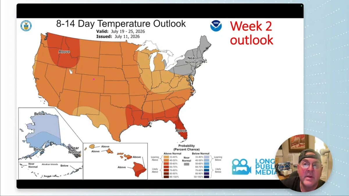
Precipitation prospects improve later in the period, but the distribution matters. The stronger monsoonal moisture remains favored along the western side of the ridge. The western states have better odds for wetter conditions, while the plains remain comparatively dry.
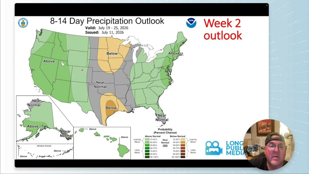
So the practical takeaway is simple: get through the hot, dry stretch through roughly July 21 or 22, and the odds improve for the familiar nearly daily summertime thunderstorm pattern to return.
Sky notes for the week
Tuesday, July 14 brings a new moon. It is a good dark sky night, weather permitting.
Sunrise is around 5:42 a.m. and sunset is around 8:29 p.m. Longmont has lost about seven minutes of daylight since the recent seasonal maximum. There is one Earth facing sunspot, but it is not magnetically complex, so there is no expectation of major solar activity from it at this time.
FAQ
Will Longmont reach 100 degrees this week?
Yes. The hottest part of the forecast is early in the week, with Monday near 100 degrees. Most other days should remain in the 90s.
Is rain expected in Longmont from July 11 through July 18?
Rain chances are very limited. Most of the week is expected to be dry, with only a small possibility of a little moisture returning by Friday.
Why are thunderstorms avoiding the Front Range?
A strong high pressure ridge is centered near Colorado. The sinking, dry air beneath it suppresses cloud growth and sends the available monsoonal moisture around Colorado rather than through Longmont.
When might Colorado’s afternoon thunderstorms return?
Moisture is expected to begin returning around July 22 or 23. Thunderstorms should become more common in the mountains first, with broader statewide activity possible later in the month.
Are fire weather conditions a concern?
Yes. Sunday and Monday bring the combination of heat, low humidity, and wind, creating elevated fire conditions while severe drought continues in the Longmont area.