
Longmont Weather Report: September 10 to September 17, 2026
Summer is not done with us yet, but there are some early hints of fall in the Longmont forecast. The period begins hot and dry, then turns noticeably more active as Gulf moisture returns to Colorado and fuels several days of afternoon thunderstorms.
Table of Contents
- A quick look at the season
- Drought, smoke, and late-season rainfall
- Longmont weather forecast: hot start, stormier finish
- Why thunderstorms return next week
- Expected rainfall coverage across Colorado
- What the longer-range outlook suggests
A quick look at the season
Thursday, September 10 brings the new moon. There are sunspots on the face of the sun, but nothing particularly active is happening, so there is no significant space-weather concern at this time.
Daylight is continuing to slip away quickly. Longmont has lost about 17 minutes of daylight during the past week, with sunrise around 6:38 a.m. and sunset near 7:13 p.m.
That seasonal shift is worth keeping in mind. September can still deliver hot afternoons, thunderstorms, and abrupt fronts, especially along the Front Range. For a broader picture of what to expect through the year, see this guide to Longmont’s four-season weather and climate.
Drought, smoke, and late-season rainfall
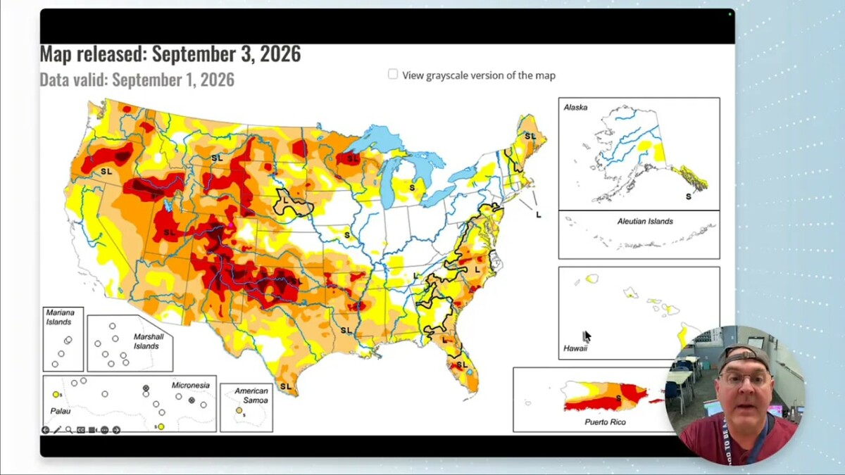
Drought conditions have worsened across southwestern Colorado, while the northeast plains have seen a little improvement. The broader national drought picture has not changed much, which is at least better than a rapid deterioration. The September outlook suggests drought conditions could improve across parts of the West.
One especially encouraging piece of news is the relatively quiet smoke situation. Given the dry conditions and drought in portions of the state, the absence of major fire smoke is fantastic.
Colorado is nearing the end of its precipitation year, currently sitting at roughly 76 percent of normal precipitation. The recent rain fell mainly along the Continental Divide and eastward, where wandering thunderstorms have been able to develop. The severe-weather season is also winding down, although there is still a small elevated chance of stronger storms next week.
Longmont weather forecast: hot start, stormier finish
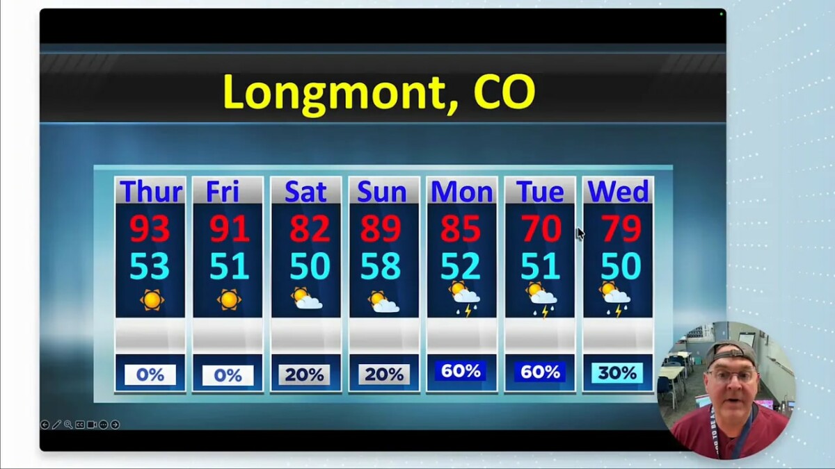
Thursday and Friday are the hot, dry days. Friday looks especially warm, with temperatures climbing into the low to middle 90s. A front south of the area helps stabilize the atmosphere for a time, keeping nearby severe weather limited.
By Saturday, a backdoor cold front drops into northeast Colorado. It moves through quickly, but it helps knock temperatures down from the early heat. Highs fall from around 81 degrees toward 77 degrees through the broader forecast period, while nighttime lows slide from around 50 toward 47 degrees.
Day-by-day pattern
- Thursday: Hot and dry, with a high near 93 degrees and a low around 53.
- Friday: Very hot and dry, reaching about 91 degrees with a low near 51.
- Saturday: Cooler, with mountain thunderstorms possible and a high near 82 degrees.
- Sunday: More moisture arrives, bringing a better chance for afternoon thunderstorms. High near 89 degrees.
- Monday: Storm chances increase further, with a high around 85 degrees and a low near 52.
- Tuesday: A cooler front brings more clouds, more moisture, and a real little taste of fall. High near 71 degrees and low near 51.
- Wednesday: Another stormy day is possible, with temperatures recovering toward 79 degrees.
Tuesday stands out as the cool day. Most temperatures remain above normal, but the front should bring cloud cover and hold daytime warmth down. There is not much of note in the wind forecast.
Why thunderstorms return next week
The big weather story is moisture. Very dry air is currently parked east of the Rockies, but the larger upper-air pattern shifts. A trough works across the northern part of the country while high pressure shifts southeastward. That setup opens a pathway for Gulf moisture to move through Arizona, the Four Corners region, and into Colorado.
By the weekend and into next week, precipitable water values rise substantially. That means there is much more moisture available in the atmosphere for afternoon thunderstorm development. Dew points climb as well, with rich low-level moisture spreading across eastern Colorado and much of the state by Tuesday and Wednesday.
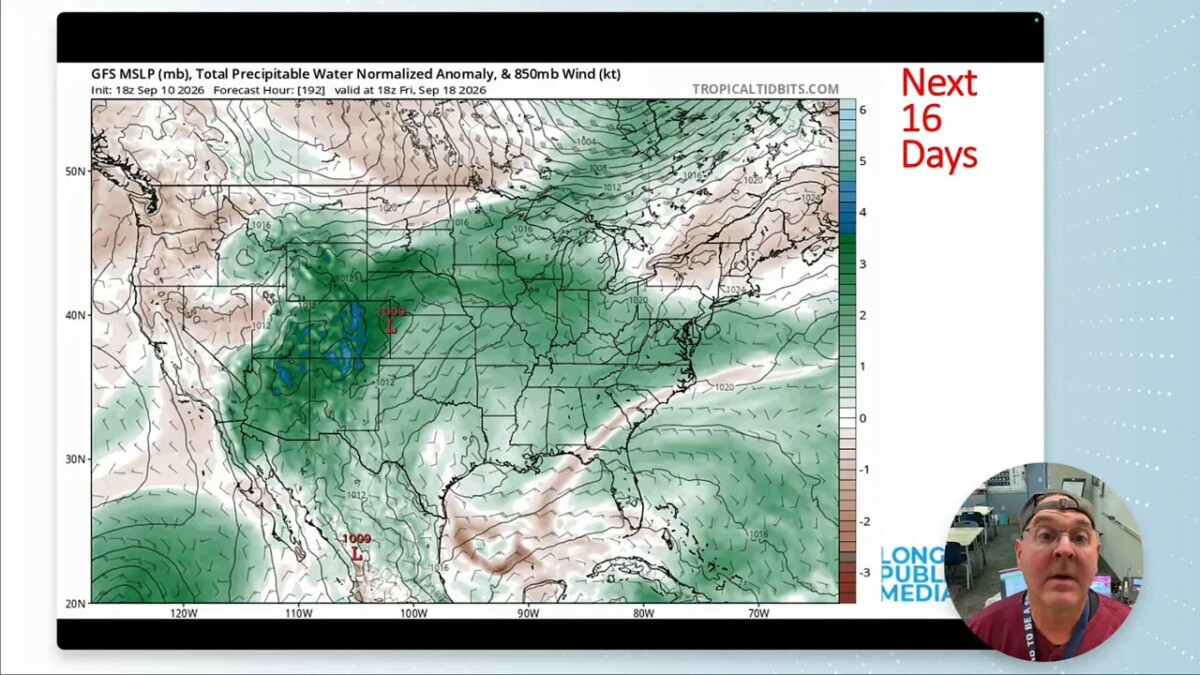
More moisture does not guarantee rain at every address, but it creates a much more favorable environment for storm development. Once daytime heating gets going, scattered thunderstorms can build over the mountains and spread across the plains.
Expected rainfall coverage across Colorado
The next few days bring spotty precipitation, primarily favoring the eastern part of the state and the western slopes. Those areas can certainly use the water.
Thunderstorm coverage expands beginning Sunday. The western slopes get the first round, followed by activity over the eastern plains. By Tuesday, much of Colorado has thunderstorm coverage. Wednesday looks especially active across central and southern Colorado, and another broad round of storms is possible Thursday.
Early next weekend, another cold front is expected to stabilize the atmosphere and shut off much of the precipitation. That front also brings another welcome hint of fall, with temperatures easing down into the 70s after the early heat and the stormier Monday through Wednesday stretch.
What the longer-range outlook suggests
The two-week outlook still leans warmer than normal overall, and the September temperature outlook also favors above-normal temperatures. That does not mean every day will be hot. Fronts and higher moisture can temporarily cool things down, as Tuesday should demonstrate.
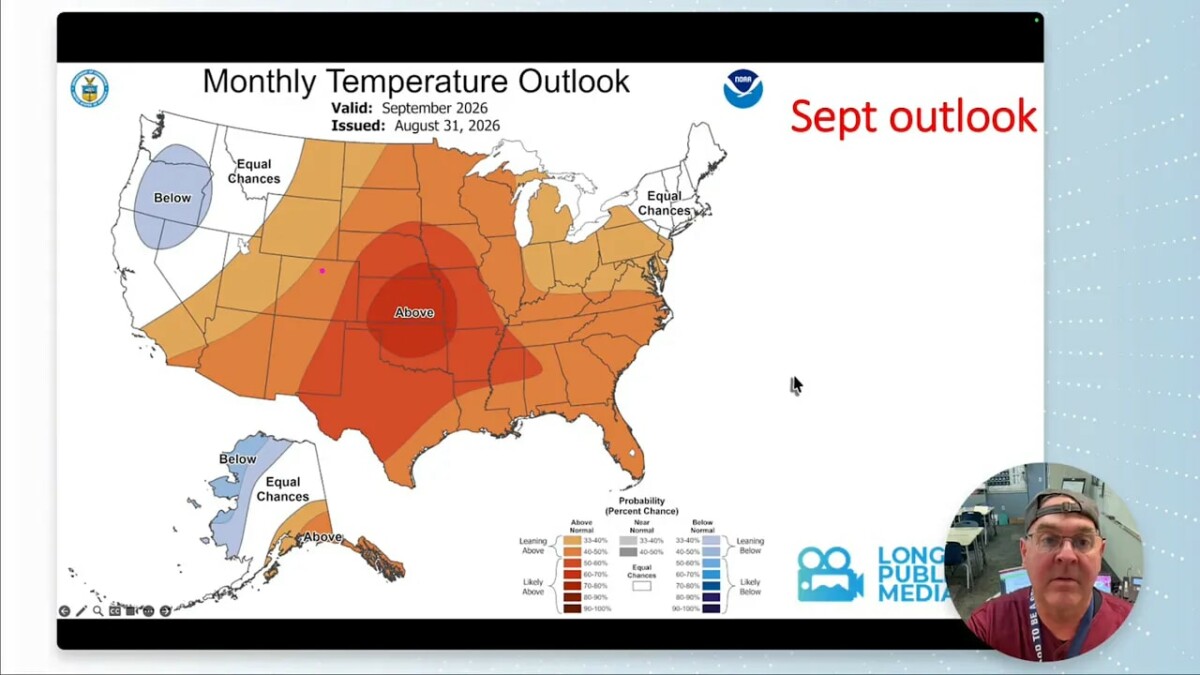
For precipitation, the second week of the outlook leans wetter than normal, and Longmont sits near the edge of the area favored for above-normal September precipitation. That is a decent setup for late-season thunderstorm opportunities, even while the overall temperature signal remains on the warm side.
Enjoy the hot, dry start, keep an eye on the sky as moisture builds, and be ready for afternoon thunderstorm chances to return in a meaningful way next week.
Longmont Weather Forecast FAQ
When does rain return to Longmont?
Thunderstorm chances begin to return Saturday in the mountains, then increase Sunday through Thursday as deeper moisture moves into Colorado.
What is the coolest day in the forecast?
Tuesday is expected to be the coolest day, with more clouds, a cool front, and a high near 71 degrees.
Will the early September heat last all week?
No. Thursday and Friday are the hottest and driest days, with temperatures in the low 90s. A front and increasing moisture bring cooler conditions and more thunderstorms after that.
Are drought conditions improving in Colorado?
Conditions have improved somewhat on the northeast plains but have worsened in southwestern Colorado. The September drought outlook indicates that improvement is possible in parts of the West.