
Longmont Weather Report: August 14 to August 21, 2026
Longmont is heading into a cooler, more unsettled stretch of August weather. Afternoon thunderstorms will be a regular feature through the weekend, with locally heavy rain possible wherever storms happen to settle. Temperatures will back off from recent heat, but the moisture and storm potential are not going away just yet.
Table of Contents
- The Big Picture: Cooler Days, Moist Air, and Daily Storm Chances
- Drought Conditions Remain a Concern
- Storm Risk Through the Weekend
- Longmont Forecast: August 14 Through August 20
- Why the Rain Chances Keep Returning
- How the Pattern Evolves Next Week
- Temperatures: A Break From the Recent Heat
- Late August Outlook
The Big Picture: Cooler Days, Moist Air, and Daily Storm Chances
The Front Range is moving into a pattern with a trough off the West Coast and a southwest flow aloft. That flow should help push much of the wildfire smoke away by Friday, improving conditions for the weekend.
At the same time, Colorado remains connected to monsoon moisture circulating around high pressure centered near Texas. That moisture, combined with daytime heating and lift from the mountains or passing disturbances, is enough to support afternoon and evening thunderstorms on many days.
The important thing to remember is that storms will not be evenly distributed. One neighborhood can get a quick downpour while another stays dry. But where a storm does track, rainfall can be very heavy. Parts of Colorado have already seen localized amounts near three inches, along with street flooding in portions of the Denver area.
Drought Conditions Remain a Concern
Despite scattered rains in the mountains and eastern plains, drought conditions have worsened from south central Colorado into northeastern Colorado. The hoped for widespread relief has not arrived, and the broader Western drought picture has not changed much.
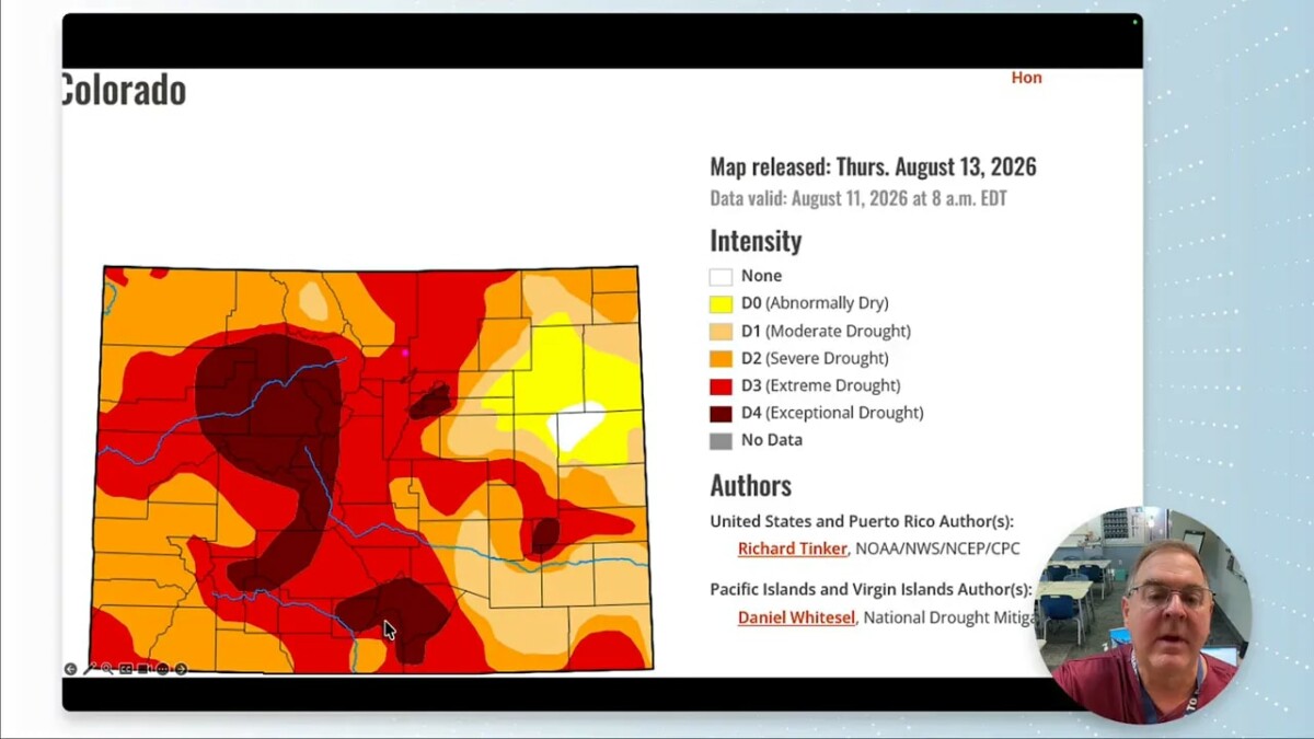
Nationally, the Western Great Plains have also continued to dry out. This is consistent with the expected drought development pattern, while much of the West remains without meaningful drought relief.
Statewide precipitation totals have slipped slightly below the median, even though some spots have picked up notable rain. That is the nature of summer thunderstorms in Colorado: beneficial rain can be very local, and a good soaking in one community does not necessarily improve conditions across the region.
Storm Risk Through the Weekend
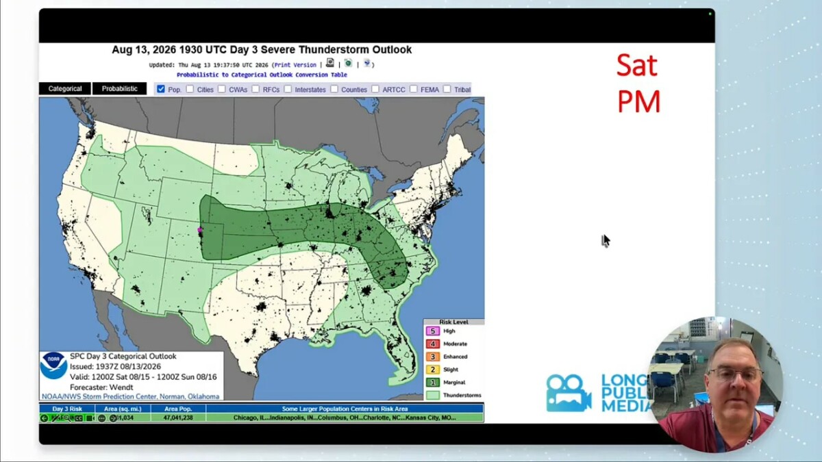
August is still part of Colorado’s active severe weather season. The probability of severe weather is elevated during June, July, and August, and this pattern continues to support a marginal risk of hail and strong winds, especially from the lower foothills eastward.
Thursday Through Saturday
- Thursday: A marginal risk for hail and high winds extends into the lower foothills. Tornado potential is not a primary concern.
- Friday: The setup remains very similar, with scattered thunderstorms capable of producing heavy rain, hail, and gusty winds.
- Saturday: Storm chances continue along and east of Interstate 25. The eastern half of Colorado remains favored for precipitation.
The stronger storms will be scattered, but slow-moving thunderstorms can produce concentrated rainfall. Heavy rain is the bigger issue with this pattern, particularly in areas that catch repeated storm cells.
Longmont Forecast: August 14 Through August 20
Temperatures are trending downward from the upper 80s toward the low 80s through the weekend. Overnight lows generally stay in the 50s, which is a fairly mild and humid setup for Colorado.
- Thursday: High near 85°F, low near 58°F, with a 50% chance of rain and thunderstorms.
- Friday: High near 81°F, low near 59°F, with a 50% chance of rain.
- Saturday: High near 80°F, low near 56°F, with a 50% chance of rain.
- Sunday: High near 84°F, low near 55°F, with a 50% chance of rain.
- Monday: High near 91°F, low near 58°F, with a lower 25% rain chance.
- Tuesday: High near 91°F, low near 57°F, with a 25% rain chance.
- Wednesday: High near 82°F, low near 56°F, with thunderstorm chances rising again to 40%.
There are no especially notable wind events in the forecast. The key weather story is the cycle of warm afternoons, mountain storm development, and storms drifting east across the plains.
Why the Rain Chances Keep Returning
Surface moisture is unusually healthy for Colorado. Dew points in the 50s and even near 60°F are high enough to provide substantial fuel for thunderstorms. That moisture lingers through the weekend before temporarily dropping into the 30s on Monday and Tuesday.
That brief dry-down should reduce rain chances early next week. But moisture is forecast to return by Wednesday and Thursday, with dew points again climbing into the 50s and 60s. That is why the thunderstorm chance rises again in the middle of the week.
Precipitable water, a measure of the total moisture in the atmosphere, is forecast to remain above normal and may become well above normal by the end of next week. The moisture is there. It just needs a trigger, such as mountain lift or a passing trough, to turn into rain.
How the Pattern Evolves Next Week
Thunderstorms should continue to develop over the mountains during the afternoon and then drift eastward. Monday may still bring a decent batch of storms, while Tuesday activity is expected to focus farther south. By Wednesday and Thursday, storm chances increase again across the region.
Looking farther ahead, a ridge of high pressure may rebuild over the West next weekend, likely near the Four Corners region. If that happens, precipitation could shut down again and the overall pattern would quiet down.
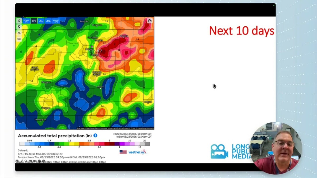
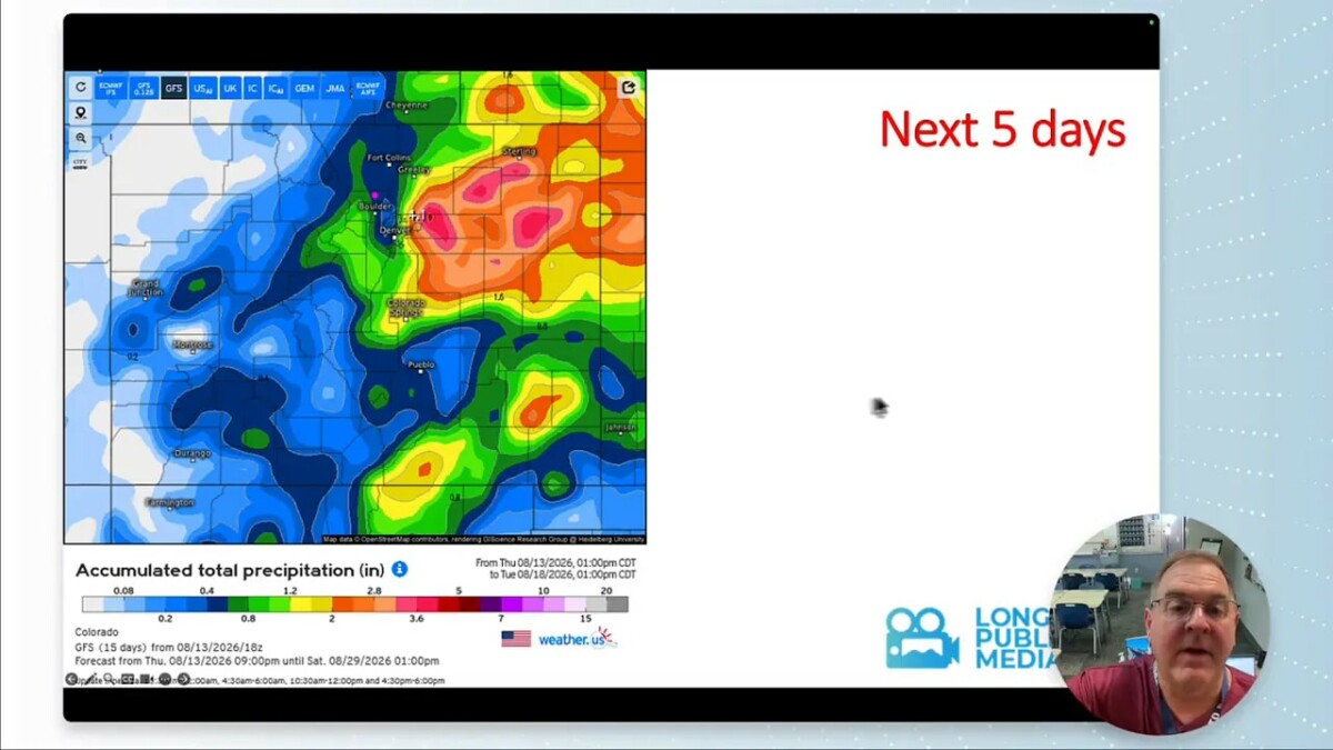
Over the next five days, northeastern and eastern Colorado are favored for the most precipitation. Extend the view to 10 days, and much more of the state has an opportunity for rain, although there is still a familiar relative minimum along the Interstate 25 corridor.
Temperatures: A Break From the Recent Heat
Normal high temperatures fall quickly in mid August, dropping from about 88°F to 82°F during this forecast window. Normal low temperatures also ease from around 59°F to 56°F. Most days in the near term should run a little above normal, but not by much.
That means Longmont is no longer looking at 100-degree heat. Instead, expect a more typical late-summer mix of warm afternoons, cooler storm-cooled pockets, and comfortable nights in the 50s.
For perspective, the record high during this 10-day period is 100°F, reached on August 14, 16, and 18 in 1962, 2002, and 2020. The record low is 40°F, set in 1910, and that is also the August monthly record low.
Late August Outlook
The second week outlook leans warmer than normal across the region. The broader August temperature outlook also favors above-normal temperatures.
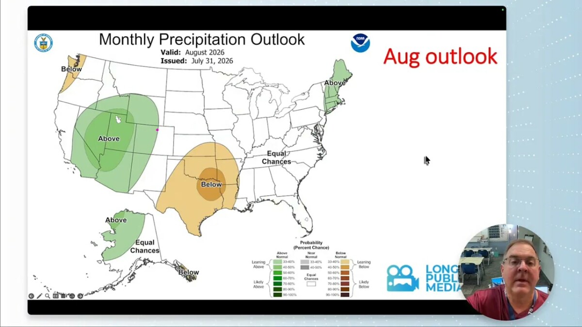
On the precipitation side, the week two outlook is encouraging for the Colorado River basin into Utah, where above-normal precipitation is favored. The August precipitation outlook also keeps above-normal precipitation close to Longmont, though the strongest signal is not directly centered over the city.
So, expect a stormy and cooler start, a short drier and warmer break Monday and Tuesday, then another return of thunderstorm potential by midweek. Keep looking up.
Frequently Asked Questions
Will Longmont get rain every day this week?
Rain and thunderstorm chances are highest from Thursday through Sunday, with lower chances Monday and Tuesday. Storm chances increase again by Wednesday.
Is severe weather expected in Longmont?
There is a marginal risk for hail and strong winds from the foothills eastward through the weekend. Locally heavy rainfall is the most notable concern where storms develop and move slowly.
Will wildfire smoke affect Longmont?
Some smoke may briefly move back into the area with a backdoor cool front on Thursday, but southwest flow is expected to push much of the smoke away by Friday.
Why can it rain heavily in one part of town but not another?
Summer thunderstorms are scattered and localized. Their rainfall can be intense, but storm tracks are narrow, so neighboring areas can experience very different conditions.