
Longmont Weather Report: July 23 Through August 1, 2026
Longmont heads into this stretch with a classic summer weather split: a cool, stormy Thursday, a hot and much drier weekend, then a return to a moist monsoon pattern next week. The rain is welcome because drought conditions have continued to worsen along the Front Range, but summertime thunderstorms remain spotty. One neighborhood can get a soaking while another barely gets enough rain to wet the pavement.
Table of Contents
- The big picture: drought, smoke, and a temporarily active monsoon
- Thursday: cooler with a strong chance of afternoon thunderstorms
- Friday through Sunday: heat returns and storm coverage drops
- Monday through Thursday: moisture and thunderstorms return
- Why the rain pattern changes so quickly
- How severe is the storm threat?
- A look beyond the immediate forecast
- Sky notes for the week
- Frequently Asked Questions
The big picture: drought, smoke, and a temporarily active monsoon
Drought has intensified around the Front Range, with the I-25 corridor moving further into extreme drought. Recent thunderstorms brought broader rainfall coverage across Colorado than the prior week, though Longmont was largely skipped. One local total came in at just 0.47 inches from a storm a couple of nights earlier, which is exactly how summer convection works around here.
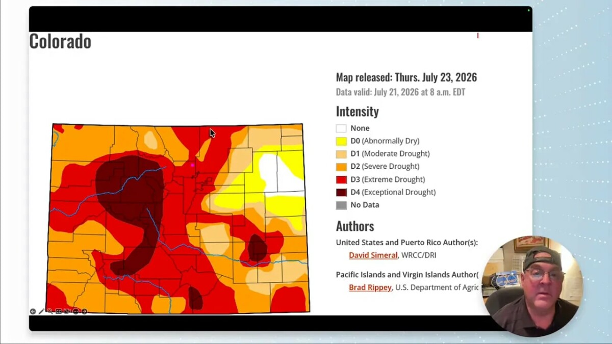
Despite the dry backdrop, the near-term weather pattern contains several opportunities for meaningful rain. The outlook points to a healthier precipitation pattern through next week, particularly over the mountains. Not every location will benefit equally, but some areas could pick up substantial totals.
Canadian wildfire smoke is also part of the regional picture. Forecast guidance showed thicker smoke plumes farther north, with a lighter amount of smoke around Colorado. It is a big-scale story, even if the local smoke impact is comparatively limited.
Thursday: cooler with a strong chance of afternoon thunderstorms
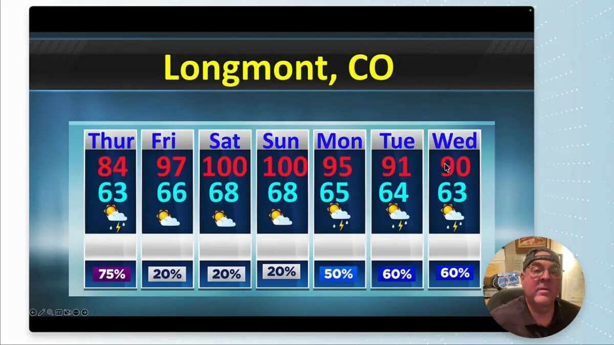
A stationary front holds temperatures down east of the Rockies on Thursday. That means a relatively pleasant high in the low 80s for Longmont, but it also comes with plenty of moisture and a good chance for afternoon thunderstorms.
Atmospheric moisture is running very high, roughly 150% to 200% of normal. With that much moisture available, storms can produce heavy rain in a hurry. The more notable severe-weather risk stays farther east across the Plains, where wind could be the main concern. Around Denver and Longmont, the bigger local issue is heavy rainfall and the possibility of localized flooding rather than classic severe storms.
Friday through Sunday: heat returns and storm coverage drops
Storm chances do not disappear after Thursday, but they become much more isolated. Friday looks markedly less active. Saturday is the hottest, driest, and windiest day of the stretch, with most storm activity favored over the mountains and western Colorado. A storm could still drift toward the I-25 corridor, but it is not something to count on.
The main reason is the position of a large upper-level ridge. As the ridge shifts over Colorado during the weekend, it suppresses thunderstorm development and nudges moisture farther west. Surface dew points also fall into the 30s and 40s, leaving the atmosphere with much less thunderstorm fuel.
Temperatures will make a strong run upward. Highs should push into the upper 90s and may reach or exceed 100 degrees during the weekend. That is a sharp turnaround from Thursday, so take the heat and wind seriously, especially with dry ground conditions still in place.
- Friday: Hotter, with only isolated storm chances.
- Saturday: Hot, dry, and windy, with storms mainly confined to the mountains.
- Sunday: A little more mountain activity is possible, but Longmont remains mostly hot and dry.
Monday through Thursday: moisture and thunderstorms return
The ridge does not stay parked in the same place. By Monday, it shifts a bit east, reopening a southerly monsoon flow into Colorado. That allows moisture to stream back in through the workweek, bringing more clouds, lower temperatures, and renewed afternoon thunderstorm chances.
This is the more promising rain window. Monday through Wednesday have good chances for storms, with Thursday also looking quite active. Dew points climb back into the 50s and may reach the 60s by midweek, which is very rich moisture for this area.
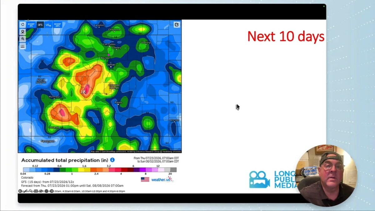
Rainfall forecasts suggest measurable precipitation is possible across much of Colorado. The general idea is not that every spot receives the same amount, but that there should be widespread opportunities. Some places may receive around a half-inch to nearly an inch over the week, while other locations could get considerably more beneath repeated storms.
Storms also help moderate the heat. It is hard to warm the atmosphere efficiently when clouds and moisture are abundant, so the early-week return of monsoon moisture should pull highs down from the weekend’s near-100-degree levels.
Why the rain pattern changes so quickly
Colorado summer weather is highly sensitive to the exact position of high pressure. With the ridge over the state, sinking air limits thunderstorm development even when some moisture remains nearby. When that high shifts east, southerly flow can transport monsoon moisture northward into Colorado.
That is the transition expected early next week. The sequence looks like this:
- A front keeps Thursday relatively cool and supports thunderstorms.
- The upper ridge builds in over the weekend, bringing hotter, drier, windier weather.
- The ridge shifts east Monday, reopening monsoon flow and restoring storm chances.
- By the end of next week, the high shifts back toward the Four Corners region, making it harder for moisture to reach the Front Range again.
That last part may set up another brief dry spell heading into early August. A front from Canada could then drop south around August 3 or 4. That front would likely cool Longmont down and could initially trigger another round of thunderstorms, while moisture may linger longer over Colorado’s Western Slope.
How severe is the storm threat?
Late July is generally a quieter period for widespread severe weather than late spring and early summer. The seasonal severe-weather focus shifts and weakens around this time, although the Eastern Plains can still see isolated wind-producing storms.
For Longmont, the more realistic concern during the wet periods is heavy rain. A storm does not have to produce large hail or damaging wind to cause problems. Slow-moving cells can dump a lot of water over a small area, particularly where drainage is poor or where burn scars and low-lying roads are involved.
Keep the distinction in mind: lots of moisture does not automatically mean severe weather, but it can mean localized flash-flood concerns when thunderstorms repeatedly form over the same place.
A look beyond the immediate forecast
The broader outlook still leans warmer than normal, consistent with the July temperature pattern. At the same time, the precipitation outlook favors above-normal precipitation thanks to the active monsoon periods. The hot, dry, windy weekend is the exception rather than the full story.
The forecast is not a straight line. It is a summer pattern with alternating pulses: heat and suppression under the ridge, then moisture, clouds, and thunderstorms as monsoon flow reopens. That is why it is worth checking conditions day by day before making outdoor plans.
Sky notes for the week
There will be a full moon on Wednesday, July 29. Sunrise is around 5:53 a.m. and sunset is around 8:22 p.m., about five fewer minutes of daylight than the previous week.
Solar activity remains quiet. A sunspot group developed quickly, but it is not magnetically complex and is not expected to produce Earth-directed impacts at this time.
In the Atlantic, Tropical Storm Bertha formed near Florida, tracked along the coast, and struggled against disruptive upper-level wind shear before weakening near Texas. It is the second named Atlantic tropical storm of the season.
Frequently Asked Questions
When is Longmont most likely to see thunderstorms?
Thursday has a strong chance of afternoon thunderstorms, followed by lower coverage Friday through Sunday. Storm chances increase again Monday through Thursday as monsoon moisture returns.
Will the weekend be cooler than Thursday?
No. Thursday should stay in the low 80s under a frontal influence, while the weekend heats up sharply. Saturday looks especially hot, dry, and windy, with temperatures approaching or exceeding 100 degrees.
Is severe weather expected in Longmont?
The more significant severe-weather potential is expected farther east on the Plains. Around Longmont, heavy rain and localized flooding are more relevant risks during the wetter thunderstorm periods.
Could next week’s rain improve drought conditions?
It could help, especially where storms repeatedly deliver heavier rainfall. However, summer thunderstorms are uneven, so rain totals will vary sharply across the region and will not erase the broader drought issue all at once.
Why do thunderstorms decrease during the hot weekend?
An upper-level ridge moves over Colorado, suppressing rising air and pushing monsoon moisture farther west. Lower surface dew points also leave less moisture available to fuel widespread thunderstorm development.