
Longmont Weather Report: August 6 to August 13, 2026
August is reminding us that summer does not leave quietly. Longmont is heading into a hot, dry stretch, with temperatures flirting with 100 degrees through the weekend before a better chance of thunderstorms develops during the middle and latter part of next week.
The big weather story is a stubborn ridge of high pressure centered near the Four Corners. It is keeping most monsoon moisture away from the Front Range for now, but that pattern is expected to shift eastward later next week. When it does, we should finally get more moisture, clouds, and scattered thunderstorms back into the picture.
Table of Contents
- August Daylight Is Slipping Away
- Drought, Rainfall, and Smoke Across Colorado
- Severe Weather Season Is Fading, but Storms Can Still Deliver
- Why the Heat Is Hanging Around
- Longmont Forecast: Hot First, Then More Storms
- Moisture Returns Later Next Week
- August Outlook: Still Warm, With a Better Monsoon Signal
August Daylight Is Slipping Away
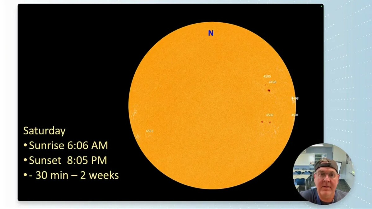
There is a new moon on Wednesday, August 12, so there will not be much moonlight out there. The sun is also quiet, with little notable activity at the moment.
More noticeably, daylight is shrinking fast. Sunrise is around 6:06 a.m., while sunset is about 8:05 p.m.. Longmont has lost roughly 30 minutes of daylight over the last two weeks, and August as a whole takes away about an hour of daylight. It is definitely becoming noticeable.
Drought, Rainfall, and Smoke Across Colorado
Drought conditions have worsened somewhat along the I-25 corridor, both north and south of Longmont. The encouraging part is that some areas of Colorado remain drought-free.
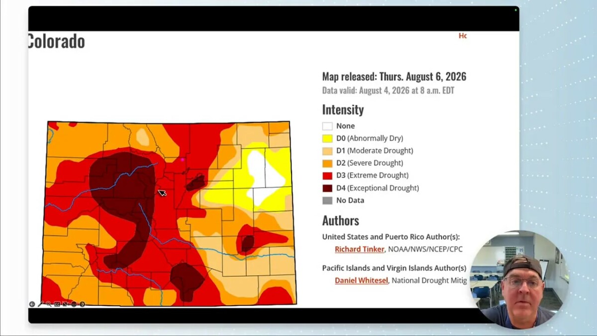
Nationally, the Southwest has seen meaningful drought relief, and that improvement is expected to continue through August. The western slopes of Colorado are included in the area where drought improvement or removal is more likely. Unfortunately, that does not put Longmont in the sweet spot just yet.
Precipitation remains near 76% of normal. There has been some rain along I-25, from Fort Collins down through Pueblo, along with better activity near the New Mexico border. It has not been enough rain, and the western slope has largely been skipped.
Another change has been the arrival of wildfire smoke. Colorado enjoyed a remarkably clear spring and much of the summer, with smoke generally passing overhead or heading into the Northeast. That has changed. The current ridge has helped trap smoke over the region, so the mountains may look hazy or disappear into the murk for a while. They are still out there, trust me.
Severe Weather Season Is Fading, but Storms Can Still Deliver
By the second week of August, Colorado remains in an elevated part of the severe-weather season, but the seasonal risk is dropping quickly. Heat and moisture can still produce hail and lively thunderstorms, though not every warm, humid day will turn into a severe-weather day.
For the immediate period, widespread convection is not expected over Colorado. The best chances remain focused away from Longmont:
- Thursday and Friday: Isolated activity mainly over southern Colorado.
- Saturday: Better chances across the mountains and southern and eastern parts of the state.
- Early next week: Storm chances gradually increase, especially over the mountains.
- Tuesday through Friday: Better odds for scattered thunderstorms on the plains, including the Front Range.
A cold front will sit to the east of Colorado early in the period, while monsoon moisture stays farther south. Neither feature makes much progress at first. The stationary setup keeps the weather pattern fairly static, and dry air remains entrenched over much of the state.
Why the Heat Is Hanging Around
The ridge is back in the West, with its center near the Four Corners region, around Utah and northern Arizona. That placement matters because it steers the deeper monsoon moisture away from the Front Range and pulls dry air into Colorado.
The ridge remains strong through much of the following week. By next weekend, however, the high-pressure center is forecast to jog east. That is the change we need. As the ridge shifts, moisture can rotate northward and back into Colorado.
Until then, temperatures stay above normal, in some cases well above normal. Normal highs are already declining from about 89 degrees toward 87 degrees, while normal overnight lows fall from near 60 to 58 degrees. Summer is slowly giving ground, even though the afternoon heat is not acting like it.
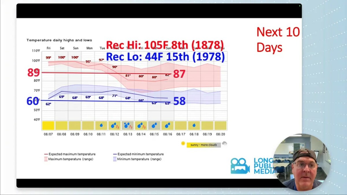
For perspective, Longmont’s all-time record high is 105 degrees. The record low around this period is 44 degrees, set on August 15, 1978. Those are not numbers we are approaching this week, but they help show just how wide the August temperature range can be.
Longmont Forecast: Hot First, Then More Storms
Thursday through Saturday will be the hottest stretch, with highs around or above 100 degrees. The weekend should cool into the 90s, but that is still above normal for early to mid-August.
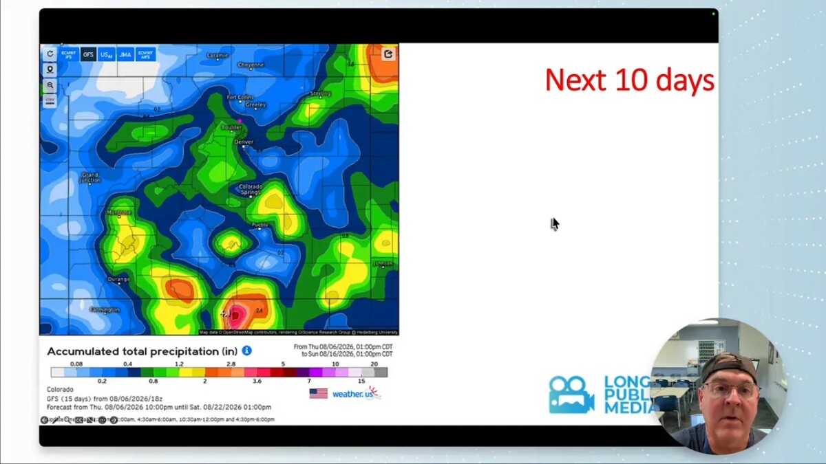
Thursday Through Monday
- Thursday: Near 101 degrees, dry, with no meaningful rain chance.
- Friday: Around 98 degrees and still dry.
- Saturday: Near 101 degrees, hot and mostly dry.
- Sunday: Around 94 degrees with a slight thunderstorm chance.
- Monday: Near 95 degrees with isolated storm potential.
Tuesday Through Wednesday
The more promising turn arrives Tuesday and Wednesday. A weak backdoor cold front may approach from the east, and storms should begin developing along its edge. Highs dip into the low 90s Tuesday and upper 80s Wednesday, while rain chances rise noticeably.
- Tuesday: Around 91 degrees with a roughly 25% chance of thunderstorms.
- Wednesday: Around 88 degrees with the best storm chance of the period, near 60%.
Rainfall over the next five days is expected to be spotty and light. The ten-day outlook is more encouraging, though any one location’s total will depend on exactly where thunderstorms form. That is the nature of summer convection: one neighborhood can get a soaking while another gets little more than gusty wind and a few drops.
Moisture Returns Later Next Week
Precipitable-water forecasts show very dry air over Colorado at first, with even New Mexico missing much of the available moisture. Better moisture sits farther west, over Arizona, southern California, Utah, and Nevada.
That begins to change around Tuesday. By the end of next week, deeper moisture should rotate around the eastward-shifting high. A tropical system near Baja may also be part of the broader moisture picture, although its exact role remains uncertain in the model guidance.
The practical takeaway is simple: the early part of the forecast is hot and dry, then the atmosphere becomes more favorable for afternoon and evening storms from Wednesday onward.
August Outlook: Still Warm, With a Better Monsoon Signal
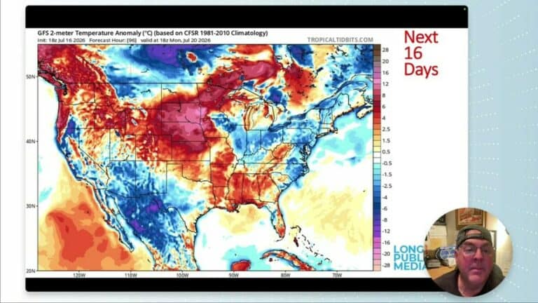
The longer-range outlook continues the broken record on temperature. The next two weeks still lean above normal, and the broader August outlook also favors warmer-than-normal conditions for Colorado and much of the West.
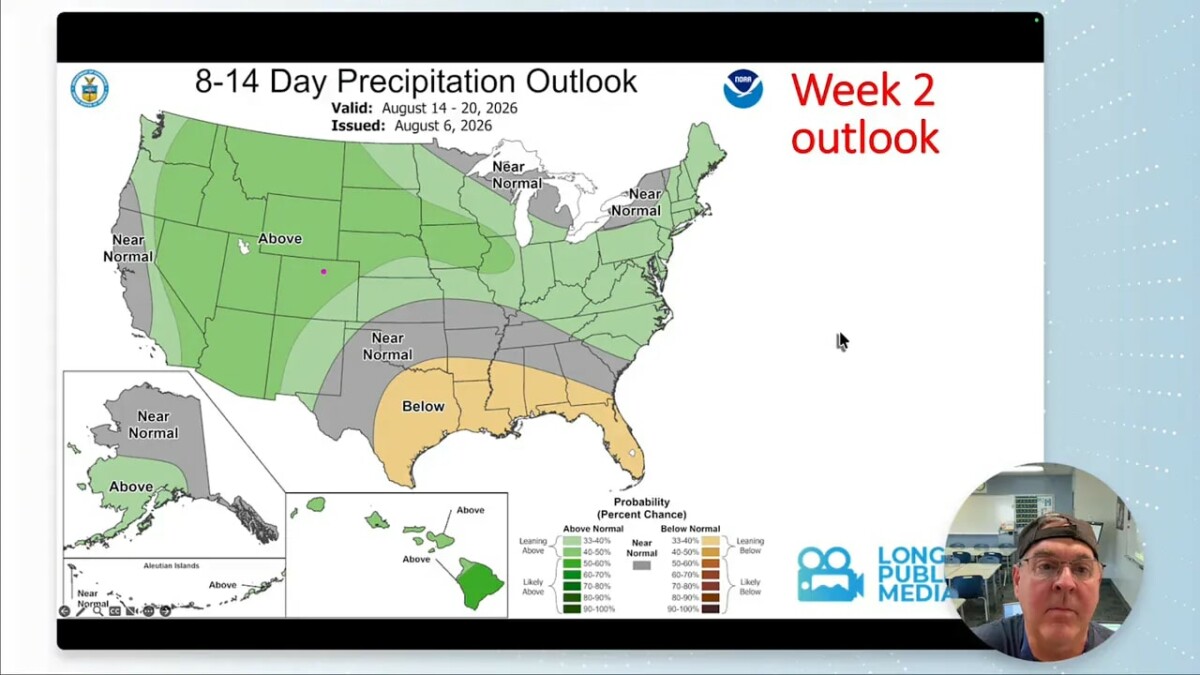
The precipitation outlook is better news. During the second week of the forecast period, the monsoon is expected to pump moisture back into Colorado. That is enough to put the western half of the state near a slightly better-than-normal precipitation signal for August.
For Longmont, that does not guarantee widespread rain every day. It does mean the odds of useful thunderstorm activity improve after this initial hot and dry run.
Keep looking up.
Frequently Asked Questions
When will Longmont have its best chance of rain?
The better chance for thunderstorms begins Tuesday and increases Wednesday through Friday as moisture returns to Colorado and temperatures ease back.
How hot will Longmont get this week?
High temperatures could reach about 100 degrees from Thursday through Saturday. Temperatures should cool into the 90s over the weekend and fall further by the middle of next week.
Why is Colorado so dry right now?
A strong ridge of high pressure near the Four Corners is steering monsoon moisture away from the Front Range and bringing dry air into Colorado.
Will drought conditions improve in Colorado?
Drought improvement is more likely across western Colorado and parts of the Southwest during August. Longmont may benefit from returning storm activity later in the forecast period, but the immediate outlook remains fairly dry.