
Longmont Weather Report: July 16, 2026 to July 21, 2026
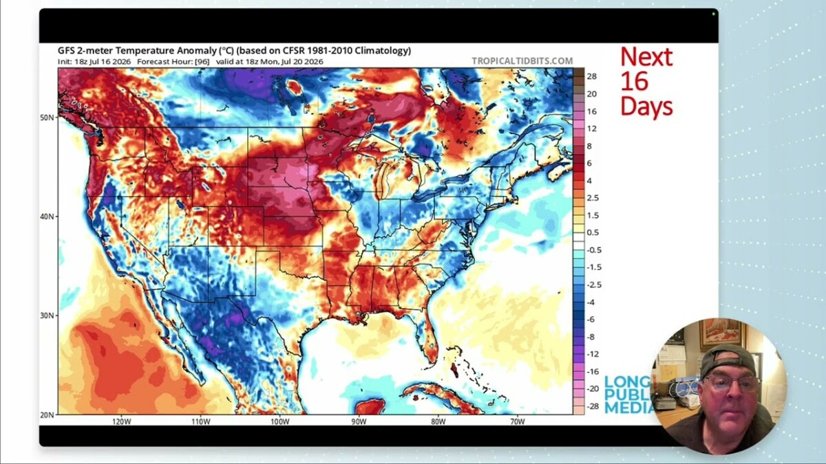
Longmont is heading into a proper stretch of July heat before the pattern finally makes a turn toward moisture, afternoon thunderstorms, and temperatures much closer to normal. The immediate message is simple: hot, dry, and sunny through the weekend, then a much better chance for rain beginning Monday night and building through the middle of next week.
Table of Contents
- The quick Longmont forecast
- Summer astronomy and daylight
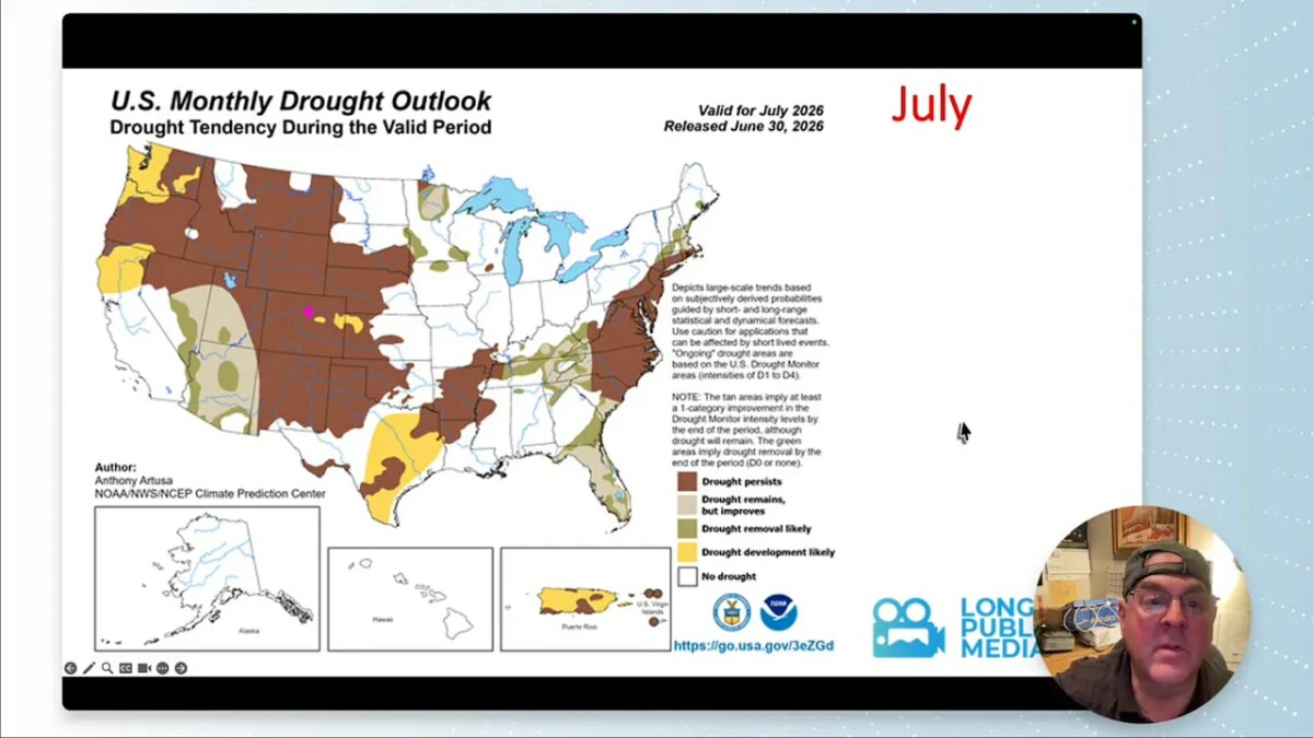
- Drought remains a concern, despite some plains relief
- Smoke, fires, and the larger weather picture
- Why it stays hot and dry at first
- Monday night brings the real pattern change
- Rain brings benefits, but lightning and wind still matter
- A look at Longmont’s temperature range
- Looking beyond July 21
- FAQ
The quick Longmont forecast
We are at the climatological peak of summer heat, with a normal high near 90 degrees. This forecast starts well above that mark, including a solid shot at upper 90s and a few locations that could touch 100 degrees Sunday.
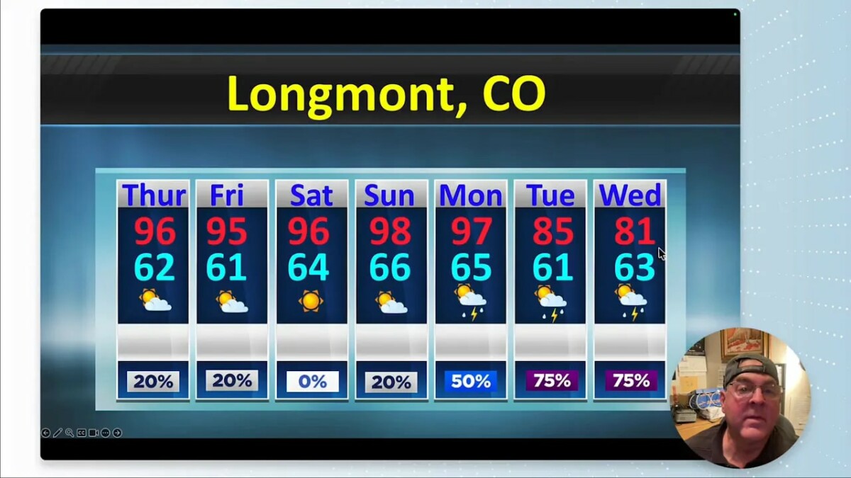
- Thursday: Hot and mostly dry, high near 96 degrees and low near 62. Rain chance around 20%.
- Friday: Mostly sunny and hot, high near 95 degrees and low near 61. Rain chance around 20%.
- Saturday: Hot and dry, high near 96 degrees and low near 64. Rain chance near zero.
- Sunday: The hottest day of the stretch, near 98 degrees, with some spots capable of reaching 100. A small storm chance returns late in the day.
- Monday: Still hot near 97 degrees, but moisture begins working back in. Rain chance rises to about 50%.
- Tuesday: Cooler near 85 degrees, with a much better chance of thunderstorms. Rain chance near 75%.
- Wednesday: High near 81 degrees, low near 63, and continued storm chances around 75%.
The early part of this period features clear, roasting sunshine. Nights remain unusually warm as well, with lows in the upper 60s to near 70 degrees at times, roughly 10 degrees above normal. Once moisture arrives, the highs come down, but humidity and overnight temperatures stay elevated.
Summer astronomy and daylight
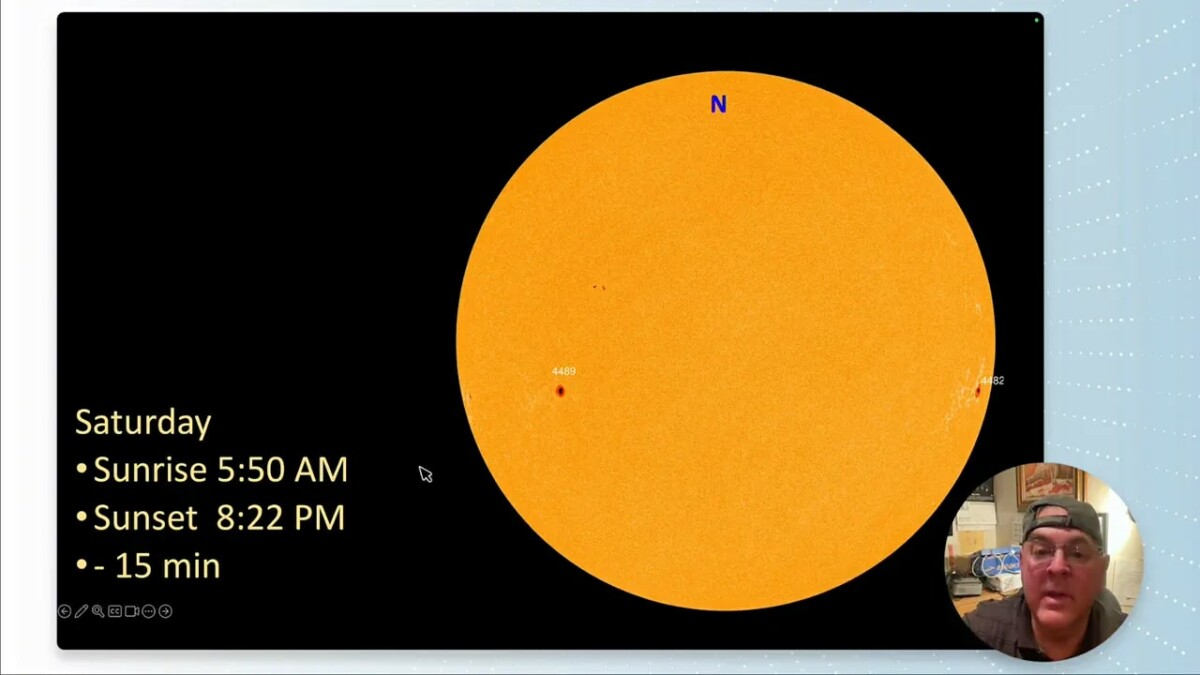
Tuesday, July 21 brings the first quarter moon. It rises around 2:00 p.m. and sets after midnight early Wednesday. The sun rises around 5:50 a.m. and sets near 8:22 p.m.
Solar activity remains quiet, with nothing notable expected to affect conditions locally.
Drought remains a concern, despite some plains relief
Colorado continues to show a mixed drought picture. Conditions have worsened in parts of the mountains, while the plains have picked up some relief. A few pockets of Colorado remain drought free, including encouraging areas in the northeast.
Recent moisture has been highly uneven. Showers east of the Continental Divide have produced spotty rainfall across the plains. Longmont received only a trace to roughly one tenth of an inch in favored spots. Total precipitation for the year remains around 72% of normal, so we still need a more reliable return of rain.
That return is coming, at least for a while. The incoming monsoon moisture could produce three quarters of an inch to more than an inch of precipitation over the next several days in some locations. A neighborhood that catches a slow moving thunderstorm cell could receive more than that.
Smoke, fires, and the larger weather picture
Canadian wildfires are producing an enormous smoke plume concentrated across the Great Lakes, New York, and the Northeast. Air quality in that region is poor enough to pose a substantial health concern for anyone spending time outdoors.
Colorado has only limited smoke influence by comparison, despite several active local fires. The broader flow around the central United States ridge is helping transport monsoon moisture northward from western Mexico through Arizona and Utah while carrying Canadian smoke east toward New England.
Texas continues to deal with major flooding, and the desert Southwest is finally seeing monsoon rains return. Heavy rain and flash flooding remain possible from Arizona into Utah, as well as portions of west and central Texas. That moisture is not far away. It just takes time for the overall pattern to shift it into Colorado.
Why it stays hot and dry at first
A large upper level ridge is sitting over the region through the weekend. Ridges encourage sinking air, which suppresses clouds and thunderstorm development even when some moisture is present in the atmosphere.
That is why there can be respectable precipitable water over Colorado without widespread rain. The moisture is there, but sinking air keeps much of it from doing much outside the mountains. A few mountain showers and lightning strikes are possible, with activity generally confined west of the Front Range and along the western slopes.
On Thursday and Friday, the Interstate 25 corridor sits close to the boundary between areas with isolated convection and areas with almost none. Severe weather is not expected nearby at first. Storm and severe weather chances are greater farther northeast, where smoke may also be part of the story.
Monday night brings the real pattern change
By Monday night into Tuesday, a front backs in from the northeast while moisture increases directly into Colorado. That front provides a focus for rising air, while monsoon flow adds the moisture thunderstorms need.
Surface dew points, which measure the low level moisture available to storms, begin fairly low for July during the hot stretch. A dew point around 45 degrees can feel dry when temperatures are in the upper 90s. By Wednesday and Thursday, dew points are expected to climb into the low 50s, providing a much richer environment for storms.
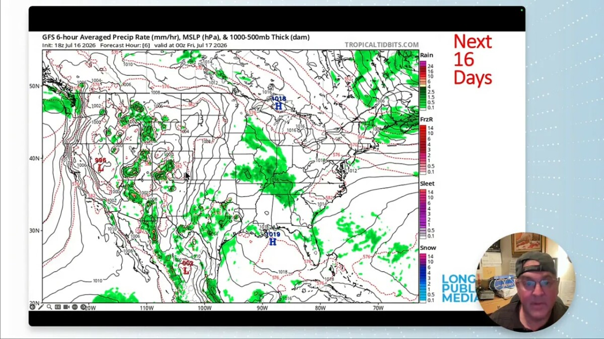
The storm pattern should develop in stages:
- Through Sunday: Most storm activity stays over Arizona, Utah, western Colorado, and the western slopes.
- Monday night through Tuesday: Storms begin pulsing back into northeast Colorado as daytime heating combines with increasing moisture.
- Wednesday through Friday: Coverage improves substantially, with widespread afternoon thunderstorm potential across more of the state and strong chances along the Front Range and plains.
This is exactly the kind of July pattern shift we need. It does not mean every location receives a soaking rain, but it gives us a genuine opportunity to reverse some of the recent dryness.
Rain brings benefits, but lightning and wind still matter
The incoming moisture is good news for drought stress, heat, and the overall summer pattern. It also comes with the usual Colorado thunderstorm hazards.
- Lightning: More thunderstorms naturally mean more lightning, which can start fires even as rain returns.
- Gusty winds: Winds pick up Sunday and Monday, which is not helpful for fire danger.
- Heavy rain: Stronger storm cells can produce locally intense rainfall, especially in mountain terrain and drainage areas.
- Severe weather: Severe weather chances have eased somewhat around Colorado for now, but could rise again once richer moisture returns. Keep an eye on weather alerts and local forecast updates.
A look at Longmont’s temperature range
The forecast includes an interesting historical benchmark. Longmont’s all time record high is 105 degrees, reached on several dates, including July 20, 2005. That same calendar date also holds the record low of 43 degrees, set in 1897.
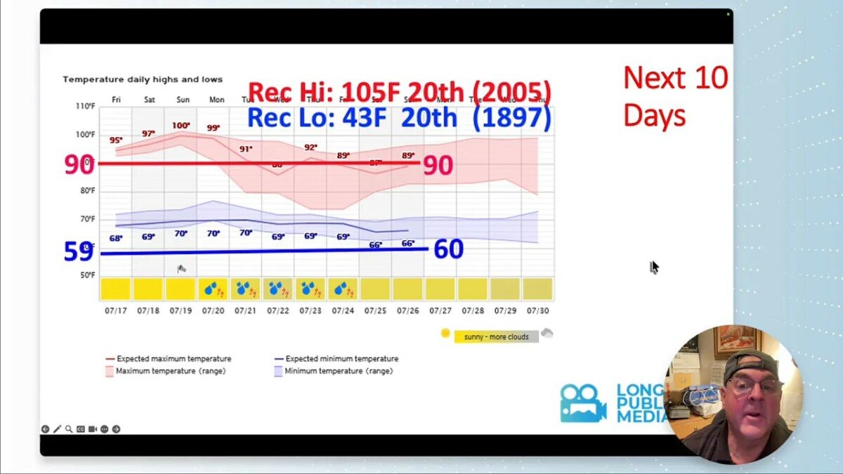
We are not forecasting a record, but Sunday is hot enough that the difference between a listed 98 degree high and an actual 100 degree reading could come down to neighborhood level details. Shade, elevation, cloud timing, and thunderstorm outflows can all matter.
Looking beyond July 21
The medium range outlook keeps temperatures leaning above normal during the second week, thanks to the persistent western ridge. Still, the moisture outlook improves, and that is fantastic news after such a dry start to the month.
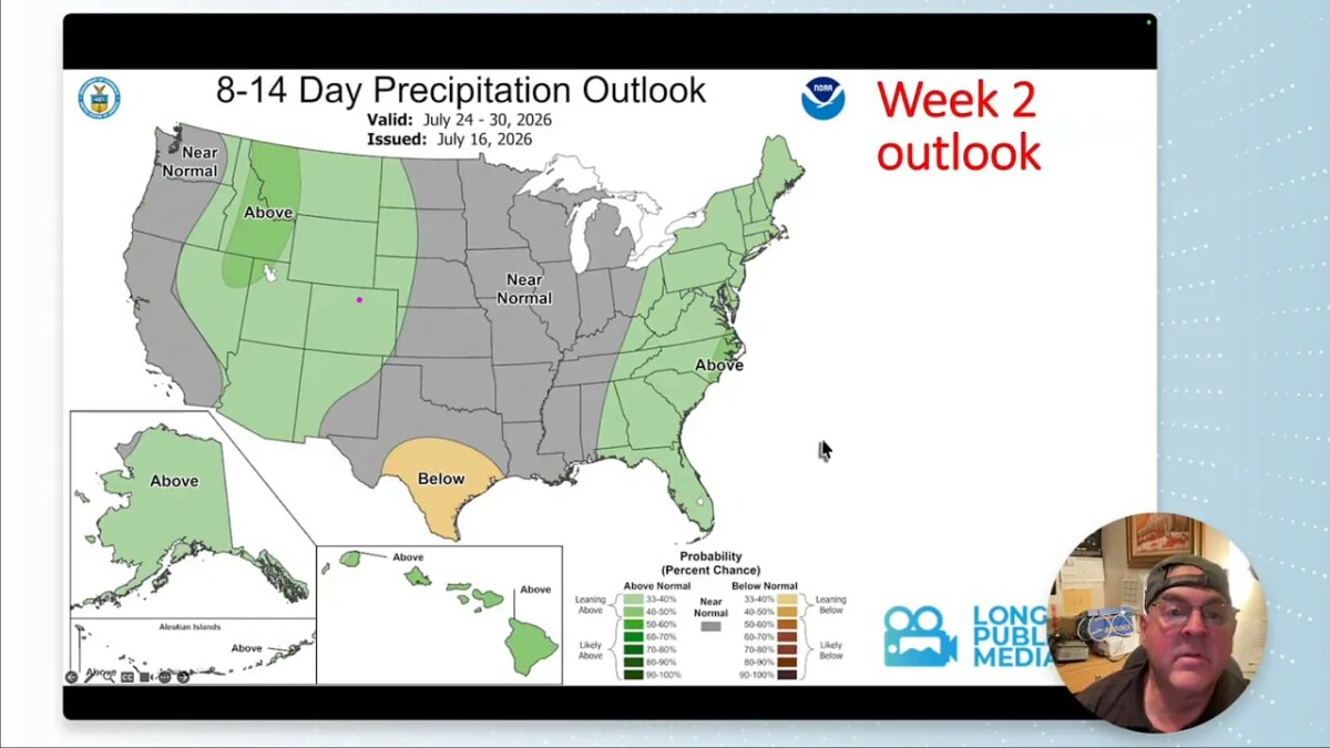
July may end up balancing out: one half very dry, followed by a considerably stormier stretch. Moisture should hold on for a while before conditions look drier again toward the end of the month.
FAQ
When will Longmont’s heat ease?
The hottest conditions hold through Monday, with highs in the mid to upper 90s. A more noticeable cooldown arrives Monday night into Tuesday as moisture and thunderstorms return, bringing highs down into the 80s.
What is the best chance for rain in Longmont?
Rain chances rise Monday night and become much stronger Tuesday through Friday. The best period for widespread afternoon thunderstorm coverage is expected from midweek into the end of the workweek.
Will the upcoming rain end Colorado’s drought?
No single storm cycle ends a drought, especially with conditions still worse in parts of the mountains. However, the expected shift toward repeated thunderstorms could provide meaningful local relief and improve the recent precipitation deficit.
Are severe thunderstorms expected in Longmont?
Severe weather is not the primary concern at the start of the period, but storm chances increase as moisture returns. Lightning, gusty winds, heavy rain, and isolated stronger storms are all possible, so monitor local alerts as the wetter pattern develops.
Why can it be so hot even with moisture nearby?
The upper level ridge promotes sinking air over Colorado. Sinking air suppresses cloud growth and thunderstorms, allowing sunshine and heat to dominate even when moisture is present nearby or overhead.
Keep looking up.